
Molde is a city and municipality in Romsdal in Møre og Romsdal county, Norway. The municipality is located on the Romsdal Peninsula, surrounding the Fannefjord and Moldefjord. The city is located on the northern shore of the Romsdalsfjord.

Vestnes is a municipality in Møre og Romsdal county, Norway. Vestnes is part of the traditional district of Romsdal. The administrative centre of the municipality is the village of Vestnes. Other villages in the municipality include Vikebukt, Vik, Øverås, Fiksdal, Tomrefjord, and Tresfjord.

Rauma is a municipality in Møre og Romsdal county, Norway. It is part of the traditional district of Romsdal. The administrative centre is the town of Åndalsnes. Other settlements in Rauma include the villages of Vågstranda, Måndalen, Innfjorden, Veblungsnes, Verma, Isfjorden, Eidsbygda, Rødven, Åfarnes, and Mittet. Most settlement in the municipality is located along the fjords and in the Romsdalen valley.

Nesset is a municipality in Møre og Romsdal county, Norway on the Romsdal Peninsula. The administrative centre is the village of Eidsvåg. Other population centers include Rausand, Boggestranda, Myklebostad, Eresfjord, and Eikesdalen.

Åndalsnes (help·info) is a town in Rauma Municipality in Møre og Romsdal county, Norway. Åndalsnes is the administrative center of Rauma Municipality. The 2.22-square-kilometre (550-acre) town has a population (2013) of 2,244, giving it a population density of 1,011 inhabitants per square kilometre (2,620/sq mi). The village of Isfjorden lies about 7 kilometres (4.3 mi) to the east, Veblungsnes lies just to the west across the Rauma River, and Innfjorden lies about 10 kilometres (6.2 mi) to the southwest via the European Route E136 highway.

The Bolsøy Bridge is a concrete beam bridge in Molde Municipality, Møre og Romsdal county, Norway. The bridge crosses the Bolsøysund strait between the mainland and the island of Bolsøya. Bolsøy Bridge was opened in 1991 as part of County Road 64, and together with the Fannefjord Tunnel, they form a ferry-free connection from the town of Molde and the island of Bolsøya to the village of Nesjestranda on the mainland.

Romsdalsfjord or Romsdal Fjord is the ninth-longest fjord in Norway. It is 88 kilometres (55 mi) long and located in the Romsdal district of Møre og Romsdal county. It flows through the municipalities of Midsund, Haram, Vestnes, Molde, Nesset, and Rauma. The deepest point in the fjord is just southwest of the town of Molde, where it is 550 metres (1,800 ft) deep. Romsdalsfjord is a threshold-fjord, as it is separated from the ocean by shallower areas at the mouth. Several islands and skerries also shelter the wide central fjord from the Atlantic.
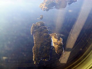
Veøya is an island in Molde Municipality in Møre og Romsdal county, Norway. It is located at a junction of the three main branches of Romsdal Fjord between the island of Sekken and the mainland near the village of Nesjestranda. The 6-square-kilometre (2.3 sq mi) island was the municipal centre of the old Veøy municipality. The island was Norway's first legally protected land, and the buildings on the island, including the Old Veøy Church, are now part of the Romsdal Museum.
Veøy is a former municipality in Møre og Romsdal county, Norway. The municipality existed from 1838 until 1964. It initially consisted of all of the present-day Vestnes Municipality, as well as the southern part of Molde Municipality and the northern part of Rauma Municipality. Vestnes Municipality was only part of Veøy for a few months in 1838 before it was made into a separate municipality. In 1964, the municipality was split between Molde and Rauma municipalities. Veøy Municipality was named after the island of Veøya, where the main church for the municipality was located.
Nesjestranda is a small village situated along Romsdal Fjord in Molde Municipality, Møre og Romsdal county, Norway. It is located along Norwegian County Road 64 on the Romsdal Peninsula facing the islands of Sekken and Veøya, just north of the mouth of the Langfjorden. The 0.38-square-kilometre (94-acre) village has a population (2013) of 441. The population density of the village is 1,161 inhabitants per square kilometre (3,010/sq mi).

Sekken is an island in Molde Municipality, Møre og Romsdal county, Norway. The island is located in Romsdal Fjord, at the mouth of the Langfjorden. The island lies about 4 kilometres (2.5 mi) south of the island of Bolsøya and about 1 kilometre (0.62 mi) west of the historic island of Veøya. There are no road connections to the 18.7-square-kilometre (7.2 sq mi) island except for a ferry connection between the town of Molde and Seterneset on the island. The proposed Langfjord Tunnel includes a possible branch off the main tunnel under the Langfjorden that would connect Sekken to the mainland by subsea road tunnel.
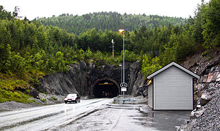
The Tussen Tunnel is a 2,840-meter (9,320 ft) long road tunnel located on County Road 64 in Møre og Romsdal county, Norway. The tunnel goes through the mountain Tussen and connects Fræna Municipality and Molde Municipality, and it cuts off about 7 kilometres (4.3 mi) from the old road that goes through a valley around the mountain. The tunnel has 5,000 daily vehicles. The tunnel was scheduled to be paid off by 2013.

The Langfjord Tunnel is a proposed subsea road tunnel which would cross Langfjorden between Molde and Rauma in Norway. It may also be built with a branch to the island of Sekken. As part of County Road 64, the tunnel would replace the Åfarnes–Sølsnes Ferry, and allow Romsdal ferry-free access to Eastern Norway, as well as connect Molde and Rauma. If the branch is built, it would replace the Molde–Sekken Ferry, giving the island a fixed link. The main tunnel would be between 10 and 11 kilometers long, which the branch would be slightly shorter than 5 kilometers (3.1 mi) long. The tunnel would reach 330 meters (1,080 ft) below mean sea level, making it the deepest subsea tunnel in the world. It would also be the longest subsea tunnel in Norway.

County Road 64 is a 126.2-kilometre (78.4 mi) two-lane highway which runs between the towns of Kristiansund and Åndalsnes in Møre og Romsdal county, Norway. It branches from National Road 70 in Kristiansund, runs through the Atlantic Ocean Tunnel, across the island of Averøya, and across the Atlantic Ocean Road to Eide Municipality. It continues to Årø in Molde Municipality via the Tussen Tunnel, then heads under Fannefjorden in the Fannefjord Tunnel, across the island of Bolsøya then over the Bolsøy Bridge to the Skåla Peninsula. It then crosses Langfjorden on the Åfarnes–Sølsnes Ferry, and enters Rauma Municipality. It intersects with the European route E136 highway in the town of Åndalsnes.

Veøy Church is a parish church in Molde Municipality in Møre og Romsdal county, Norway. It is located in the village of Sølsnes. The church is part of the Røvik og Veøy parish in the Molde arch-deanery in the Diocese of Møre. The red, wooden church was built in 1907 in the style known as dragestil. The architect was Karl Norum. The church seats approximately 200 people. The church was built to replace the Old Veøy Church which was located on the nearby island of Veøya.

Sølsnes is a village in Molde Municipality in Møre og Romsdal county, Norway. The village is located on the Romsdal Peninsula at the confluence of the Karlsøyfjorden and the Langfjorden. The village of Nesjestranda lies about 2.5 kilometres (1.6 mi) north of Sølsnes. The Old Veøy Church is located on the island of Veøya, off the coast from Sølsnes. That church is now a museum and it was replaced in 1907 by a new Veøy Church which was built in Sølsnes.
Røvika is a village in Molde Municipality in Møre og Romsdal county, Norway. The village is located at the end of the Karlsøyfjorden on the Romsdal Peninsula, about 10 kilometres (6.2 mi) southeast of the town of Molde. The village sits along the Norwegian County Road 64, at the eastern end of the Bolsøy Bridge. Røvik Church is located in the village.


