Åmot, Buskerud

Last updated
Åmot
Village

Aamot buskerud IMG 4941 Embretsfoss kraftverk.jpg

Embretsfoss kraftverk
Country Norway
Region Østlandet
County Buskerud
Time zone CET (UTC+01:00)
  Summer (DST) CEST (UTC+02:00)
Amot Church in Modum Aamot kirke Modum 260305.JPG
Åmot Church in Modum

Åmot is a village in Modum municipality in Buskerud, Norway. Located just south of Geithus, the two villages have grown closer to each other. They have a combined population of 5,694. [1]

Modum Municipality in Buskerud, Norway

Modum is a municipality in Buskerud county, Norway. The administrative centre of the municipality is the town of Vikersund. The municipality of Modum was established on 1 January 1838.

Buskerud County (fylke) of Norway

Buskerud is a county in Norway, bordering Akershus, Oslo, Oppland, Sogn og Fjordane, Hordaland, Telemark and Vestfold. The county extends from the Oslofjord and Drammensfjorden in the southeast to Hardangervidda mountain range in the northwest. The county administration is located in Drammen. Together with Akershus and Østfold, Buskerud will form the new, larger county Viken, from 1 January 2020.

Norway constitutional monarchy in Northern Europe

Norway, officially the Kingdom of Norway, is a Nordic country in Northwestern Europe whose territory comprises the western and northernmost portion of the Scandinavian Peninsula; the remote island of Jan Mayen and the archipelago of Svalbard are also part of the Kingdom of Norway. The Antarctic Peter I Island and the sub-Antarctic Bouvet Island are dependent territories and thus not considered part of the kingdom. Norway also lays claim to a section of Antarctica known as Queen Maud Land.

Contents

History

Four waterfalls (Embretsfoss, Døvikfoss, Kongsfoss and Haugfoss) in the immediate vicinity have contributed greatly to the industrial history of Åmot. These waterfalls have served to power several hydroelectric plants. Kongsfoss kraftverk is a hydroelectric power plant first built in 1920. The present power plant was put into operation in 2004, utilizes waterfall from Kongsfoss on the Simoa. Embretsfoss kraftverk was first put into operation in 1916, and utilizes the waterfall at Embretfoss on the Drammenselva. Additional power plants were added in 1921, 1954 and 2013. Haugfoss kraftverk is a hydroelectric power plant which utilizes waterfall from the Haugfoss on the Simoa. The plant was first built in 1938 and modified in 1988. Døvikfoss kraftverk, which was put into operation in 1975, is powered by the waterfall from Døvikfoss on the Drammenselva. [2] [3] [4] [5]

Simoa river in Norway

Simoa is the name of a river which flows through the municipalities of Sigdal and Modum in Buskerud County, Norway.

Drammenselva river in Norway

Drammenselva is a river in Buskerud county, southeastern Norway.

Åmot Church

Åmot Church (Åmot kirke) was consecrated on May 16, 1996. It replaced a chapel, dating from 1906, which was destroyed by fire. Åmot Church belongs to the Modum parish in Eiker deanery. The church was constructed of brick and seats 220 in the nave. [6]

Nave main body of a church

The nave is the central part of a church, stretching from the main entrance or rear wall, to the transepts, or in a church without transepts, to the chancel. When a church contains side aisles, as in a basilica-type building, the strict definition of the term 'nave' is restricted to the central aisle. In a broader, more colloquial sense, the nave includes all areas available for the lay worshippers, including the side-aisles and transepts. Either way, the nave is distinct from the area reserved for the choir and clergy.

Related Research Articles

Sigdal Municipality in Buskerud, Norway

Sigdal is a municipality in Buskerud county, Norway. The administrative centre of the municipality is the village of Prestfoss.

Skotselv Village in Østlandet, Norway

Skotselv is a village in the municipality of Øvre Eiker, Norway. Its population (2005) is 684, of which 8 people live within the border of the neighbouring municipality of Modum. It has a railway station on the Randsfjord Line.

Hvittingfoss

Hvittingfoss is a village in the municipality of Kongsberg in Buskerud, Norway. Hvittingfoss has traditionally been associated with the manufacture of pulp, paper and paper products.

Skollenborg

Skollenborg is a small village in the municipality of Kongsberg in Buskerud county, Norway.

Tisleifjorden

Tisleifjorden is a Norwegian lake which lies in Nord-Aurdal municipality in Oppland county, as well in Gol and Hemsedal municipalities in Buskerud county. Tisleifjorden is dammed for hydroelectric power. The height of the lake can vary up to 11 meters. It is 13.54 km2 (5.23 sq mi) in area and 32.53 km around. It has an elevation of 819 m above sea level. Tisleifjorden Dam creates a reservoir for the Åbjøra kraftverk hydro-electric power plant at Aurdalsfjord in Oppland. The power plant was built in the years 1949-1951 and was rebuilt in 2002. Åbjøra kraftverk is operated by Skagerak Energi.

Eggedal

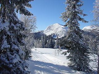
Eggedal is a valley and parish in Buskerud county, Norway. It consisting of the northwestern half of the municipality of Sigdal.

Stolsvatnet is a regulated lake in the municipalities of Ål and Hol in Buskerud county, Norway. Stolsvatnet was formed in the late 1940s by the damming of the upper parts of three rivers, which created a continuous lake across the watersheds. The new lake covered a number of existing smaller lakes. It is a reservoir for Hol I kraftverk, a hydroelectric power plant located off FV 50 by Hovet in Hol. The power plant is owned and operated by E-Co Energi.

Nygardsvatnet is a lake in the municipality of Hol in Buskerud county, Norway. The lake is situated south of the Hallingskarvet mountain range. The lake serves as a reservoir for Usta kraftverk, a hydroelectric plant which was put into operation in 1965. The water level is controlled by a dam at the outlet and a tunnel down to lakes Sløddfjorden and Ustevatn. The Usta kraftverk power plant is owned and operated by E- CO Energi.

Vavatn

Vavatn is a lake in the municipality of Hemsedal in Buskerud county, Norway. It is a water source for Gjuva kraftverk, a hydro-electric power plant, which utilizes the waterfall from the lake into the Gjuva river as it enters the valley of Grøndalen. The power station was put into operation in 1957 but was rehabilitated in 1995. The owner-operator is E- CO Energi.

Ørteren

Ørteren is a lake in the municipality of Hol in Buskerud county, Norway.

Rødungen lake in Nore og Uvdal and Ål, Buskerud, Norway

Rødungen is a lake in Buskerud county, Norway. The lake is located on the border between the municipalities of Ål and Nore og Uvdal. Waterfall from the lake is a power source for Usta kraftverk, a hydro-electric plant. The power station exploits the fall of the Usta river from Rødungen as well as Ustevatn.The plant started production in 1965 and is owned and operated by E- CO Energi.

Hen, Buskerud

Hen is a small village in the municipality of Ringerike in Buskerud, Norway.

Geithus

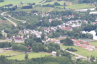
Geithus is a village in Modum municipality of Buskerud, Norway. It is situated between the villages of Åmot and Vikersund.

Kaggefoss

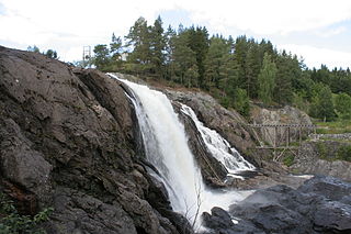
Kaggefoss is a waterfall on the Snarumselva river in the municipality of Modum in Buskerud, Norway.

Buskerud Manor was a former estate and manor located on a large farm in Buskerud, Norway. The modern county of Buskerud is named for the estate.

Evanger (village) Village in Western Norway, Norway

Evanger is a village in the municipality of Voss in Hordaland county, Norway. The village lies in western Voss at the eastern end of the lake Evangervatnet where the river Vosso empties into the lake. Evanger sits about 20 kilometres (12 mi) west of the municipal centre of Vossevangen.

References

Coordinates: 59°53′35″N9°55′35″E / 59.89306°N 9.92639°E / 59.89306; 9.92639

Geographic coordinate system Coordinate system

A geographic coordinate system is a coordinate system that enables every location on Earth to be specified by a set of numbers, letters or symbols. The coordinates are often chosen such that one of the numbers represents a vertical position and two or three of the numbers represent a horizontal position; alternatively, a geographic position may be expressed in a combined three-dimensional Cartesian vector. A common choice of coordinates is latitude, longitude and elevation. To specify a location on a plane requires a map projection.