Geithus

Last updated

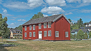
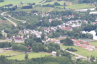
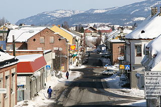
Geithus is a village in Modum municipality of Buskerud, Norway. It is situated between the villages of Åmot and Vikersund. [1]

Modum Municipality in Buskerud, Norway

Modum is a municipality in Buskerud county, Norway. The administrative centre of the municipality is the town of Vikersund. The municipality of Modum was established on 1 January 1838.

Buskerud County (fylke) of Norway

Buskerud is a county in Norway, bordering Akershus, Oslo, Oppland, Sogn og Fjordane, Hordaland, Telemark and Vestfold. The county extends from the Oslofjord and Drammensfjorden in the southeast to Hardangervidda mountain range in the northwest. The county administration is located in Drammen. Together with Akershus and Østfold, Buskerud will form the new, larger county Viken, from 1 January 2020.

Åmot, Buskerud Village in Østlandet, Norway

Åmot is a village in Modum municipality in Buskerud, Norway. Located just south of Geithus, the two villages have grown closer to each other. They have a combined population of 5,694.

Gravfoss 1 kraftverk. Gravfoss 1 kraftverk.JPG
Gravfoss 1 kraftverk.

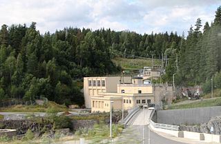
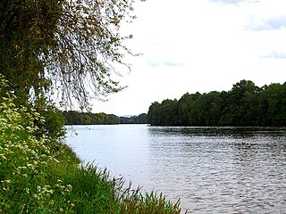
Geithus is located where the southwestern arm of Tyrifjorden ends and drains into Drammenselva. Geithusbrua is a cable bridge, that spans the junction where Tyrifjorden turns into Drammenselva. There are two hydroelectric powerplants; Geithusfoss kraftverk and Gravfoss kraftverk. The area around Geithus in forested. Originally, there was an active pulp and paper industry in Geithus principally through the operation of Katfos Fabrikker. Production of paper, pulp and cellulose started in 1898. The operating was sold to Norske Skog Follum in 1970 and production stopped in 1983. [2] [3] [4]

Tyrifjorden lake in Norway

Tyrifjorden is a lake in Norway. It lies 40 kilometres (25 mi) northwest of Oslo and is the nation's fifth largest lake with an area of 137 km2. It has a volume of 13 km3, is 295 meters deep at its deepest, and lies 63 meters above sea level. The lake's primary source is the Begna river, which discharges into Tyrifjorden at Hønefoss where the river forms the waterfall of Hønefossen. Its primary outlet is at Vikersund near the lake's southwest corner, where Tyrifjorden discharges into the Drammenselva river.

Drammenselva river in Norway

Drammenselva is a river in Buskerud county, southeastern Norway.

Pulp and paper industry an industry that belongs to the primary industry and is involved in the manufacture of paper and paperboard

The pulp and paper industry comprises companies that use wood as raw material and produce pulp, paper, paperboard and other cellulose-based products.

There is a forty-minute trip to Drammen, and a little over an hour to Oslo. Until 2004, you could get to Geithus by train. Geithus rail station (Geithus stasjon) was built in 1875 as part of the Randsfjorden Line. Today it is closed, even though locals have demanded to get their station back. [5]

Oslo Place in Østlandet, Norway

Oslo is the capital and most populous city of Norway. It constitutes both a county and a municipality. Founded in the year 1040 as Ánslo, and established as a kaupstad or trading place in 1048 by Harald Hardrada, the city was elevated to a bishopric in 1070 and a capital under Haakon V of Norway around 1300. Personal unions with Denmark from 1397 to 1523 and again from 1536 to 1814 reduced its influence, and with Sweden from 1814 to 1905 it functioned as a co-official capital. After being destroyed by a fire in 1624, during the reign of King Christian IV, a new city was built closer to Akershus Fortress and named Christiania in the king's honour. It was established as a municipality (formannskapsdistrikt) on 1 January 1838. The city's name was spelled Kristiania between 1877 and 1897 by state and municipal authorities. In 1925 the city was renamed Oslo.

Randsfjorden Line railway line

The Randsfjorden Line is an 87-kilometre-long (54 mi) railway located in Buskerud in Norway connecting Drammen to Hønefoss and Hadeland in Oppland. The railway is primarily used for passenger trains, and the only scheduled trains on the stretch are Norwegian State Railways express trains on the Bergen Line between Oslo and Bergen. Freight trains to Bergen go to Hønefoss via the Gjøvik Line. The railway is owned by the Norwegian National Rail Administration.

Related Research Articles

Olaf Nordhagen Norwegian architect

Johan Olaf Brochmann Nordhagen was a Norwegian educator, architect, engineer and artist. He is most commonly associated with his restoration designs for Nidaros Cathedral in Trondheim, Norway.

Skotselv Village in Østlandet, Norway

Skotselv is a village in the municipality of Øvre Eiker, Norway. Its population (2005) is 684, of which 8 people live within the border of the neighbouring municipality of Modum. It has a railway station on the Randsfjord Line.

Hvittingfoss

Hvittingfoss is a village in the municipality of Kongsberg in Buskerud, Norway. Hvittingfoss has traditionally been associated with the manufacture of pulp, paper and paper products.

Skollenborg

Skollenborg is a small village in the municipality of Kongsberg in Buskerud county, Norway.

Stolsvatnet is a regulated lake in the municipalities of Ål and Hol in Buskerud county, Norway. Stolsvatnet was formed in the late 1940s by the damming of the upper parts of three rivers, which created a continuous lake across the watersheds. The new lake covered a number of existing smaller lakes. It is a reservoir for Hol I kraftverk, a hydroelectric power plant located off FV 50 by Hovet in Hol. The power plant is owned and operated by E-Co Energi.

Vavatn lake in Hemsedal, Norway

Vavatn is a lake in the municipality of Hemsedal in Buskerud county, Norway. It is a water source for Gjuva kraftverk, a hydro-electric power plant, which utilizes the waterfall from the lake into the Gjuva river as it enters the valley of Grøndalen. The power station was put into operation in 1957 but was rehabilitated in 1995. The owner-operator is E- CO Energi.

Ørteren

Ørteren is a lake in the municipality of Hol in Buskerud county, Norway.

Rødungen lake in Nore og Uvdal and Ål, Buskerud, Norway

Rødungen is a lake in Buskerud county, Norway. The lake is located on the border between the municipalities of Ål and Nore og Uvdal. Waterfall from the lake is a power source for Usta kraftverk, a hydro-electric plant. The power station exploits the fall of the Usta river from Rødungen as well as Ustevatn.The plant started production in 1965 and is owned and operated by E- CO Energi.

Hen, Buskerud

Hen is a small village in the municipality of Ringerike in Buskerud, Norway.

Vestfossen

Vestfossen is a village in the municipality of Øvre Eiker in the county of Buskerud, Norway. Vestfossen is a former industrial city with traditions dating back to the 16th century. As of 2008 Vestfossen had a population of 2,867 according to Statistics Norway.

Norwegian Museum of Hydropower and Industry

The Norwegian Museum of Hydropower and Industry is a cultural history museum at Odda in Hordaland, Norway. The museum is located in the village of Tyssedal. The museum is dedicated to the industrial history of Odda and Tyssedal, and more generally to history related to rivers and water, hydropower production, electricity, power intensive industry and its society.

Kaggefoss

Kaggefoss is a waterfall on the Snarumselva river in the municipality of Modum in Buskerud, Norway.

Ulla-Førre lake in Suldal, Norway

Ulla-Førre is a hydropower complex in Suldal, Hjelmeland and Bykle in Norway. It has an installed capacity of approximately 2,100 MW, and the annual average production is 4.45 TWh (16.0 PJ) (1987-2006), while its annual potential is about 7.8 TWh (28 PJ). The complex includes the artificial lake Blåsjø, which is made by dams around 1,000 metres (3,300 ft) above the sea level. The hydroelectric power station in the complex are Saurdal, Kvilldal, Hylen and Stølsdal, operated by Statkraft.

Bratsberg Hydroelectric Power Station building in Trondheim, Trøndelag, Norway

Bratsberg Power Station is a hydroelectric power station located in Trondheim in Sør-Trøndelag County, Norway, owned by Statkraft. It operates at an installed capacity of 124 MW, with an average annual production of 650 GWh. The power plant is fed from the Selbusjøen reservoir, connected with a 12 km long tunnel, offering a gross head of 147 m. The power plant has two Francis turbines.

Aurland Hydroelectric Power Station building in Aurland, Sogn og Fjordane, Norway

The Aurland Power Station is a hydroelectric power station located in the municipality Aurland in Sogn og Fjordane, Norway, owned by E-CO Energi. It consists of five facilities, Aurland I, Aurland II, Aurland III, Reppa and Vangen, and operates at a combined installed capacity of 1,128 MW, with an average annual production of 2,869 GWh. The construction works were initiated in 1969, and the first production from Aurland I started in 1973.

Tunnsjødal Hydroelectric Power Station building in Namsskogan, Nord-Trøndelag, Norway

The Tunnsjødal Power Station is a hydroelectric power station located in Namsskogan, Nord-Trøndelag, Norway. It operates at an installed capacity of 176 MW, with an average annual production of 820 GWh.

Evanger (village) Village in Western Norway, Norway

Evanger is a village in the municipality of Voss in Hordaland county, Norway. The village lies in western Voss at the eastern end of the lake Evangervatnet where the river Vosso empties into the lake. Evanger sits about 20 kilometres (12 mi) west of the municipal centre of Vossevangen.

Ragnvald Blakstad was a Norwegian industrialist and hydropower pioneer. He is best known for developing hydropower in the Arendal watershed, and for the Tyssedal Hydroelectric Power Station and Aura Hydroelectric Power Station.

References

  1. Geir Thorsnæs Geithus (Store norske leksikon)
  2. Knut A Rosvold. "Gravfoss kraftverk". Store norske leksikon. Retrieved September 15, 2016.
  3. Knut A Rosvold. "Geithusfoss kraftverk". Store norske leksikon. Retrieved September 15, 2016.
  4. Katfos Fabrikker (lokalhistoriewiki.no)
  5. Geithus stasjon (Groundspeak, Inc.)

Coordinates: 59°57′N9°59′E / 59.950°N 9.983°E / 59.950; 9.983

Geographic coordinate system Coordinate system

A geographic coordinate system is a coordinate system that enables every location on Earth to be specified by a set of numbers, letters or symbols. The coordinates are often chosen such that one of the numbers represents a vertical position and two or three of the numbers represent a horizontal position; alternatively, a geographic position may be expressed in a combined three-dimensional Cartesian vector. A common choice of coordinates is latitude, longitude and elevation. To specify a location on a plane requires a map projection.