The Antarctic is a polar region around the Earth's South Pole, opposite the Arctic region around the North Pole. The Antarctic comprises the continent of Antarctica, the Kerguelen Plateau and other island territories located on the Antarctic Plate or south of the Antarctic Convergence. The Antarctic region includes the ice shelves, waters, and all the island territories in the Southern Ocean situated south of the Antarctic Convergence, a zone approximately 32 to 48 km wide varying in latitude seasonally. The region covers some 20 percent of the Southern Hemisphere, of which 5.5 percent is the surface area of the Antarctic continent itself. All of the land and ice shelves south of 60°S latitude are administered under the Antarctic Treaty System. Biogeographically, the Antarctic ecozone is one of eight ecozones of the Earth's land surface.

The French Southern and Antarctic Lands is an overseas territory of France. It consists of:
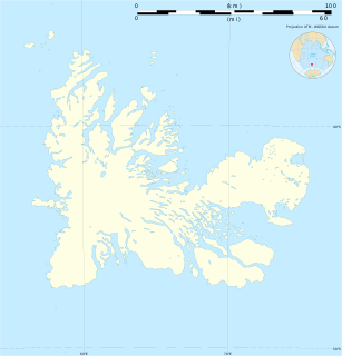
- Kerguelen Islands, a group of volcanic islands in the southern Indian Ocean, southeast of Africa, approximately equidistant between Africa, Antarctica and Australia;
- St. Paul and Amsterdam islands, a group to the north of Kerguelen;
- Crozet Islands, a group in the southern Indian Ocean, south of Madagascar;
- Adélie Land, the French claim on the continent of Antarctica;
- the Scattered Islands, a dispersed group of islands around the coast of Madagascar.
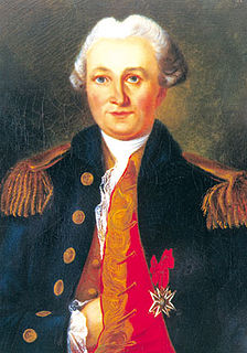
Yves-Joseph de Kerguelen-Trémarec was a French explorer and naval officer.

The Kerguelen Plateau is an oceanic plateau and a large igneous province (LIP) located on the Antarctic Plate, in the southern Indian Ocean. It is also a microcontinent and submerged continent. It is about 3,000 km (1,900 mi) to the southwest of Australia and is nearly three times the size of Japan. The plateau extends for more than 2,200 km (1,400 mi) in a northwest–southeast direction and lies in deep water.
The French Antarctic Expedition is any of several French expeditions in Antarctica.

The Gauss expedition of 1901–1903 was the first German expedition to Antarctica. It was led by geologist Erich von Drygalski in the ship Gauss, named after the mathematician and physicist Carl Friedrich Gauss.

Île Saint-Lanne Gramont is an uninhabited island, the fourth largest island in the Kerguelen Islands, situated to the north of presqu'île de la Société de géographie, with an area of 45.8 km². It reaches 480 m at its highest point and is located at 48°55′25″S69°10′54″E. The island is elongated along a north-south axis, reaching a maximum length of 13 km and a maximum width of 3 km. It is free of introduced animals.
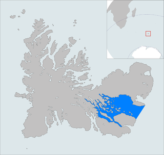
The Courbet Peninsula is a large peninsula in northeastern Grande Terre Island, the main island of the subantarctic Kerguelen Archipelago, Southern Indian Ocean. In the south of the peninsula is Port-aux-Français, the principal station of the archipelago.
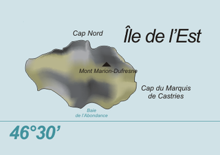
Île de l'Est, or East Island, is a part of the subantarctic archipelago of the Crozet Islands. With an area of 130 km2 (50 sq mi) it is the second largest island of the group. It is part of the French Southern and Antarctic Lands.

The Kerguelen shag is a species of cormorant endemic to the Kerguelen Islands in the southern Indian Ocean, one of the most isolated places on Earth. Many authorities consider it a subspecies of the imperial shag.

Île de la Possession, or Possession Island, formerly Île de la Prise de Possession, is part of the subantarctic Crozet Archipelago.

Île des Pingouins, or Penguin Island, is an uninhabited island in the subantarctic Crozet Archipelago of the southern Indian Ocean. With an area of only 3 km2 (1 sq mi) it is one of the smaller islands of the group. Administratively, it is part of the French Southern and Antarctic Lands. It is an important nesting site for seabirds.
The Îles Leygues, or Leygues Islands, also sometimes known as the Îles Swain, comprise a group of small islands and islets that are part of the subantarctic Kerguelen archipelago, a French territory in the southern Indian Ocean.
The Îles Nuageuses comprise a group of small islands that are part of the subantarctic Kerguelen archipelago, a French territory in the southern Indian Ocean. They are important as a breeding site for seabirds, especially penguins and albatrosses, and for fur seals.

Île Australia, also known as Île aux Rennes is one of the Kerguelen Islands situated in the Golfe du Morbihan near the coast of Grande Terre, the principal island.

Bekas Rock is the 140 m long in southwest-northeast direction and 60 m wide rock lying west of Rugged Island on the west side of Livingston Island in the South Shetland Islands, Antarctica. The area was visited by early 19th century sealers.

Kondor Island is the 320 m long in west–east direction and 140 m wide rocky island lying off the north coast of Nelson Island in the South Shetland Islands, Antarctica.
Fregata Island is the 480 m long in southeast-northwest direction and 230 m wide rocky island lying off the north coast of Nelson Island in the South Shetland Islands, Antarctica.