


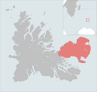
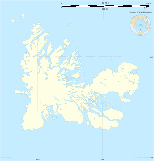
The Golfe du Morbihan (Gulf of Morbihan) is a bay on the eastern coast of Grande Terre, the largest of the Kerguelen islands. It forms a deep and broad notch in the central section of the island.
The Golfe du Morbihan (Gulf of Morbihan) is a bay on the eastern coast of Grande Terre, the largest of the Kerguelen islands. It forms a deep and broad notch in the central section of the island.
It is a relatively protected maritime space constituting a natural shelter for the ships and on the banks of which were established the stations of Port-Jeanne-d'Arc and Port-aux-Français. The gulf of Morbihan is strewn with many islands and islets. It was thus so called by Raymond Rallier du Baty at the time of its forwardings of the beginning of the 20th century in the honour of the Gulf of Morbihan in Brittany (Kerguelen was Breton, and many of the features in the islands have Breton names). "Morbihan" derives directly from the Breton name which is Ar Morbihan, meaning 'the little sea' (Compare the Welsh y môr bychan), as opposed to the Ocean outside.
The name of Gulf of Morbihan appears on a chart published in 1922. Previously the place was known as Royal Sound, given by James Cook. This remains in the name of Passe Royale, the entry of the gulf. The name Golfe du Morbihan was confirmed by the French toponymy commission for the Southern and Antarctic Lands, thus respecting the hierarchy of the topographic terms, since the Golfe du Morbihan includes several smaller bays such as the Baie des Aurores Australes, where Port-aux-Français is located. However the name Baie du Morbihan appears on various charts and is often used indifferently even in official writings.
The islands of the gulf have been identified by BirdLife International as a 280 km2 Important Bird Area (IBA) because of their value as breeding sites for seabirds and for Eaton's pintails. Of the 20 islands and numerous islets included in the IBA, the largest is the 20 km2 Île Australia. Some of the islands are free of introduced species, but others are infested by rats, mice and rabbits. Some islands still have their original subantarctic vegetation, including Kerguelen cabbages, lyallia cushions and Moseley's buttercups. They are of particular interest because of their large populations of blue and grey petrels. Other birds breeding in the IBA include Kerguelen, great-winged, white-chinned and white-headed petrels, Antarctic and slender-billed prions, Wilson's and grey-backed storm petrels, South Georgia and common diving petrels, Kerguelen shags, black-faced sheathbills, brown skuas and Kerguelen terns. [1]

The Kerguelen Islands, also known as the Desolation Islands, are a group of islands in the Antarctic constituting one of the two exposed parts of the Kerguelen Plateau, a large igneous province mostly submerged by the southern Indian Ocean. They are among the most isolated places on Earth, located more than 3,300 km (2,100 mi) from Madagascar. The islands, along with Adélie Land, the Crozet Islands, Amsterdam and Saint Paul Islands, and France's Scattered Islands in the Indian Ocean, are part of the French Southern and Antarctic Lands and are administered as a separate district.

Morbihan is a department in the administrative region of Brittany, situated in the northwest of France. It is named after the Morbihan, the enclosed sea that is the principal feature of the coastline. It is noted for its Carnac stones, which predate and are more extensive than the Stonehenge monument in Wiltshire, England.

The Gulf of Morbihan is a natural harbour on the coast of the Département of Morbihan in the south of Brittany, France. This English name is taken from the French version: le golfe du Morbihan. It is more accurately called 'the Morbihan' directly from its Breton name which is Ar Mor Bihan, meaning 'the little sea', as opposed to the Atlantic Ocean outside,. Legend says that there are as many islands in the Gulf as there are days of the year. However, this is untrue and the gulf has about 40, depending on the tide. Many islands are private property, except the largest two, l'Île-aux-Moines and l'Île-d'Arz.

The Îlots des Apôtres or Îles des Apôtres are a group of small and uninhabited rocky islands in the north-western part of the Crozet Archipelago in the southern Indian Ocean, 10 km (6.2 mi) north of Île aux Cochons. Their total area is about 2 km2 (0.77 sq mi).

Île-aux-Moines is a commune in the Morbihan department in the region of Brittany in north-western France.
The Courbet Peninsula is a peninsula in northeastern Grande Terre Island, the main island of the subantarctic Kerguelen Archipelago, Southern Indian Ocean. In the south of the peninsula is Port-aux-Français, the principal station of the archipelago.

The Rallier du Baty Peninsula is a peninsula of Grande Terre, the main island of the subantarctic Kerguelen archipelago in the southern Indian Ocean. It occupies the south-western corner of the island, and is about 35 km long, extending from north to south, and 25 km across at its widest. The 1,202 m high Bicorne rises in the southern coast of the peninsula. It is named for Raymond Rallier du Baty, a French sailor who charted the archipelago in the early 20th century. The Îles Boynes, France's southernmost land apart from Adélie Land in Antarctica, lie 30 km south of the tip of the peninsula.
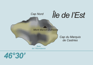
Île de l'Est, or East Island, is a part of the subantarctic archipelago of the Crozet Islands. With an area of 130 km2 (50 sq mi) it is the second largest island of the group. It is part of the French Southern and Antarctic Lands.
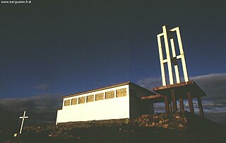
Notre-Dame des Vents is a Roman Catholic church located in Port-aux-Français, the capital settlement of the Kerguelen Islands, Territory of the French Southern and Antarctic Lands in the south Indian Ocean.
Lions Rump is a conspicuous headland 2 km (1.2 mi) north-northeast of Low Head, forming the west side of the entrance to King George Bay, on King George Island, in the South Shetland Islands of Antarctica. It was charted and given its descriptive name in 1937 by Discovery Investigations personnel on the Discovery II. Chopin Ridge runs between Lions Rump and Low Head. The rock feature known as "Martello Tower" lies 4 km (2.5 mi) to the north-northwest.

The Mackellar Islands, also MacKellar Islets, are a group of about 30 small islands and rocks lying 3 kilometres (1.5 nmi) north of Cape Denison in the center of Commonwealth Bay, George V Land, Antarctica. They were discovered by the Australasian Antarctic Expedition (1911–14) under Douglas Mawson, who named them for C.D. Mackellar of London, a patron of the expedition. The largest is Greater Mackellar Island.

Île de la Possession, or Possession Island, formerly Île de la Prise de Possession, is part of the Subantarctic Crozet Archipelago.

Île des Pingouins, or Penguin Island, is an uninhabited island in the subantarctic Crozet Archipelago of the southern Indian Ocean. With an area of only 3 km2 (1 sq mi) it is one of the smaller islands of the group. Administratively, it is part of the French Southern and Antarctic Lands. It is an important nesting site for seabirds.

Péninsule Jeanne d'Arc, also known as Presqu'île Jeanne d'Arc, is a peninsula of Grande Terre, the main island of the subantarctic Kerguelen archipelago in the southern Indian Ocean.
The Péninsule Loranchet, also known as Presqu'île Loranchet, is a peninsula of Grande Terre, the main island of the subantarctic Kerguelen archipelago in the southern Indian Ocean.

Baie Larose, or Larose Bay in English, is a bay of Grande Terre, the main island of the subantarctic Kerguelen archipelago, a French territory in the southern Indian Ocean. It is important as a breeding site for seabirds, especially penguins.
Les Îles Leygues or the Leygues Islands, occasionally called « les Îles Swain », are a group of small islands and islets that are part of the subantarctic Kerguelen archipelago, a French territory in the southern Indian Ocean.
The Îles Nuageuses comprise a group of small islands that are part of the Kerguelen archipelago, a French territory in the southern Indian Ocean. They are an important breeding spot for seabirds, especially penguins and albatrosses, and for fur seals.

The Southern Powell Island and adjacent islets Specially Protected Area is a 2688 ha site encompassing part of southern Powell Island in the South Orkney Islands of Antarctica. It includes neighbouring Christoffersen, Fredriksen, Michelsen and Grey Islands, along with some other (unnamed) offshore islets. It was designated an Antarctic Specially Protected Area because of its biological values as it supports many plants and animals that exemplify the natural ecology of the South Orkney Islands. It is also a breeding site for Antarctic fur seals.
Baie de l'Oiseau is a natural harbour in the Loranchet Peninsula, in the North-Western part of the island Grande Terre, part of the Kerguelen Islands. It was the landing site of the expedition under Yves de Kerguelen in 1772, and later of the expedition under James Cook in 1776. The site of Port-Christmas is part of the bay.