

The Péninsule Loranchet, also known as Presqu'île Loranchet, (Loranchet Peninsula in English) is a peninsula of Grande Terre, the main island of the subantarctic Kerguelen archipelago in the southern Indian Ocean.
The Péninsule Loranchet, also known as Presqu'île Loranchet, (Loranchet Peninsula in English) is a peninsula of Grande Terre, the main island of the subantarctic Kerguelen archipelago in the southern Indian Ocean.
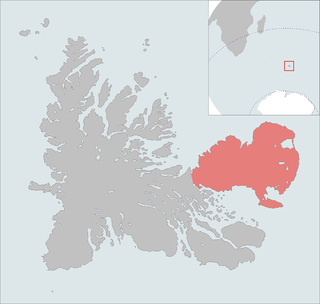
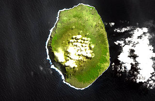
The peninsula occupies the north-western corner of Grande Terre and is named after Jean Loranchet, the first officer of Raymond Rallier du Baty’s second Kerguelen survey expedition in 1913. It has a rugged, mountainous interior, with altitudes exceeding 500 m and a coastline of steep cliffs deeply incised by fjords. It is some 50 km long with a width of up to 20 km. As with most of Grande Terre, it is infested with introduced feral cats, rats and rabbits. Human visitation is infrequent. [1]
The northern end of the peninsula, and the northernmost part of Grande Terre, extending northwards from the head of the Baie de la Dauphine, has been identified as a 60 km2 Important Bird Area (IBA) by BirdLife International because of its breeding seabirds. At least 23 bird species breed in the IBA. As well as a colony of 250,000 pairs of macaroni penguins at the tip of the peninsula, there are also 5,400 pairs of southern rockhopper penguins and a small colony of 400 pairs of black-browed albatrosses. Cape petrels and Kerguelen shags nest on the cliffs. Other birds include light-mantled albatrosses, Kerguelen terns and Eaton's pintails. Antarctic fur seals and southern elephant seals breed in the IBA. [1]

The Kerguelen Islands, also known as the Desolation Islands, are a group of islands in the sub-Antarctic constituting one of the two exposed parts of the Kerguelen Plateau, a large igneous province mostly submerged in the southern Indian Ocean. They are among the most isolated places on Earth, located more than 3,300 kilometres from Madagascar. The islands, along with Adélie Land, the Crozet Islands, Amsterdam and Saint Paul islands, and France's Scattered Islands in the Indian Ocean, are part of the French Southern and Antarctic Lands and are administered as a separate district.

The Antarctic realm is one of eight terrestrial biogeographic realms. The ecosystem includes Antarctica and several island groups in the southern Atlantic and Indian oceans. The continent of Antarctica is so cold that it has supported only 2 vascular plants for millions of years, and its flora presently consists of around 250 lichens, 100 mosses, 25–30 liverworts, and around 700 terrestrial and aquatic algal species, which live on the areas of exposed rock and soil around the shore of the continent. Antarctica's two flowering plant species, the Antarctic hair grass and Antarctic pearlwort, are found on the northern and western parts of the Antarctic Peninsula. Antarctica is also home to a diversity of animal life, including penguins, seals, and whales.

The Seal Islands are a group of small islands and rocky islets lying about 7 km north and north-west of Elephant Island, in the South Shetland Islands of Antarctica. They extend east–west for about 5 km, and are separated from Elephant Island by Sealers Passage. The group takes its name from the largest island, which Captain William Smith named Seal Island in 1820 because of the number of seals killed there.
The Courbet Peninsula is a peninsula in northeastern Grande Terre Island, the main island of the subantarctic Kerguelen Archipelago, Southern Indian Ocean. In the south of the peninsula is Port-aux-Français, the principal station of the archipelago.

The Rallier du Baty Peninsula is a peninsula of Grande Terre, the main island of the subantarctic Kerguelen archipelago in the southern Indian Ocean. It occupies the south-western corner of the island, and is about 35 km long, extending from north to south, and 25 km across at its widest. The 1,202 m high Bicorne rises in the southern coast of the peninsula. It is named for Raymond Rallier du Baty, a French sailor who charted the archipelago in the early 20th century. The Îles Boynes, France's southernmost land apart from Adélie Land in Antarctica, lie 30 km south of the tip of the peninsula.
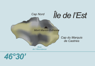
Île de l'Est, or East Island, is a part of the subantarctic archipelago of the Crozet Islands. With an area of 130 km2 (50 sq mi) it is the second largest island of the group. It is part of the French Southern and Antarctic Lands.
Bird Island is one of the Falkland Islands. It lies due south of West Falkland, near Port Stephens and Calm Head. It has been identified as an Important Bird Area (IBA) by BirdLife International.
The Southern Indian Ocean Islands tundra is a tundra ecoregion that includes several subantarctic islands in the southern Indian Ocean.

Watson Peninsula is a narrow peninsula 4 km (2.5 mi) long separating Macdougal and Marr Bays on the north coast of Laurie Island, in the South Orkney Islands of Antarctica. It was charted in 1903 by the Scottish National Antarctic Expedition under Bruce, who named it for G.L. Watson, yacht designer and redesigner of the expedition ship Scotia.
Lions Rump is a conspicuous headland 2 km (1.2 mi) north-northeast of Low Head, forming the west side of the entrance to King George Bay, on King George Island, in the South Shetland Islands of Antarctica. It was charted and given its descriptive name in 1937 by Discovery Investigations personnel on the Discovery II. Chopin Ridge runs between Lions Rump and Low Head. The rock feature known as "Martello Tower" lies 4 km (2.5 mi) to the north-northwest.
The Falaises d'Entrecasteaux comprise the cliffs, which reach heights of over 700 m, along the west coast of Amsterdam Island, a small French territory in the southern Indian Ocean.

Île aux Cochons, or Pig Island, is an uninhabited island in the subantarctic Crozet Archipelago. With an area of 67 km2 (26 sq mi) it is the third largest island of the group. Administratively, it is part of the French Southern and Antarctic Lands.

Île de la Possession, or Possession Island, formerly Île de la Prise de Possession, is part of the Subantarctic Crozet Archipelago. Administratively, it is part of the French Southern and Antarctic Lands. It is an important nesting site for seabirds.

Île des Pingouins, or Penguin Island, is an uninhabited island in the subantarctic Crozet Archipelago of the southern Indian Ocean. With an area of only 3 km2 (1 sq mi) it is one of the smaller islands of the group. Administratively, it is part of the French Southern and Antarctic Lands. It is an important nesting site for seabirds.
Péninsule Jeanne d'Arc, also known as Presqu'île Jeanne d'Arc, is a peninsula of Grande Terre, the main island of the subantarctic Kerguelen archipelago in the southern Indian Ocean.

Baie Larose, or Larose Bay in English, is a bay of Grande Terre, the main island of the subantarctic Kerguelen archipelago, a French territory in the southern Indian Ocean. It is important as a breeding site for seabirds, especially penguins.
Les Îles Leygues or the Leygues Islands, occasionally called « les Îles Swain », are a group of small islands and islets that are part of the subantarctic Kerguelen archipelago, a French territory in the southern Indian Ocean.
The Îles Nuageuses comprise a group of small islands that are part of the Kerguelen archipelago, a French territory in the southern Indian Ocean. They are an important breeding spot for seabirds, especially penguins and albatrosses, and for fur seals.

Hope Harbour is an inlet at the north-west of West Falkland in the Falkland Islands of the South Atlantic Ocean. About 4 km long and 1.3 km wide, it is sheltered by the promontory of Grave Cove Camp in the south, a narrow ridge terminating in Hope Point to the north, Bramble Point Camp to the east, and West Point Island at its entrance to the west. Carcass Island lies 8 km north-east of Hope Point.
Baie de l'Oiseau is a natural harbour in the Loranchet Peninsula, in the North-Western part of the island Grande Terre, part of the Kerguelen Islands. It was the landing site of the expedition under Yves de Kerguelen in 1772, and later of the expedition under James Cook in 1776. The site of Port-Christmas is part of the bay.
48°42′S69°00′E / 48.700°S 69.000°E
| | This French Southern Territories location article is a stub. You can help Wikipedia by expanding it. |