

Baie Larose, or Larose Bay in English, is a bay of Grande Terre, the main island of the subantarctic Kerguelen archipelago, a French territory in the southern Indian Ocean. It is important as a breeding site for seabirds, especially penguins.
Baie Larose, or Larose Bay in English, is a bay of Grande Terre, the main island of the subantarctic Kerguelen archipelago, a French territory in the southern Indian Ocean. It is important as a breeding site for seabirds, especially penguins.
The bay lies on the southern coast of Grande Terre, west of Mont Ross and Gallieni Massif, and encompassing the mouth of Fjord Larose and the tilted monolith known as the Doigt de Sainte Anne (Saint Anne's Finger). [1]
The bay, with part of the south-western slopes of Mont Ross, has been identified as a 20 km2 Important Bird Area (IBA) by BirdLife International because of its breeding seabirds. Of the penguins, there are some 21,500 pairs of kings, 500 pairs of gentoos, 6000 pairs of macaronis and 4000 pairs of eastern rockhoppers. Other birds nesting in the IBA include a few pairs of wandering albatrosses, Antarctic and slender-billed prions, white-chinned, northern giant and common diving petrels, Kerguelen shags, Kerguelen terns, black-faced sheathbills and Eaton's pintails. Antarctic fur seals and southern elephant seals also breed on the shores of the bay. [1]

The Kerguelen Islands, also known as the Desolation Islands, are a group of islands in the sub-Antarctic constituting one of the two exposed parts of the Kerguelen Plateau, a large igneous province mostly submerged in the southern Indian Ocean. They are among the most isolated places on Earth, located more than 3,300 kilometres from Madagascar. The islands, along with Adélie Land, the Crozet Islands, Amsterdam and Saint Paul islands, and France's Scattered Islands in the Indian Ocean, are part of the French Southern and Antarctic Lands and are administered as a separate district.
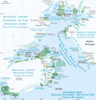
Admiralty Bay is an irregular bay, 8 km (5 mi) wide at its entrance between Demay Point and Martins Head, indenting the southern coast of King George Island for 16 km (10 mi), in the South Shetland Islands of Antarctica. The name appears on a map of 1822 by Captain George Powell, a British sailor, and is now established in international usage. The Henryk Arctowski Polish Antarctic Station is situated on the bay, as is the Comandante Ferraz Brazilian Antarctic Base. It has been designated an Antarctic Specially Managed Area.

Penguin Island is one of the smaller of the South Shetland Islands of Antarctica.

The Îlots des Apôtres or Îles des Apôtres are a group of small and uninhabited rocky islands in the north-western part of the Crozet Archipelago in the southern Indian Ocean, 10 km (6.2 mi) north of Île aux Cochons. Their total area is about 2 km2 (0.77 sq mi).

Île Foch is one of the Kerguelen Islands situated near to the north coast of Grande Terre, the principal island.
The Courbet Peninsula is a peninsula in northeastern Grande Terre Island, the main island of the subantarctic Kerguelen Archipelago, Southern Indian Ocean. In the south of the peninsula is Port-aux-Français, the principal station of the archipelago.
The Golfe du Morbihan is a bay on the eastern coast of Grande Terre, the largest of the Kerguelen islands. It forms a deep and broad notch in the central section of the island.

The Rallier du Baty Peninsula is a peninsula of Grande Terre, the main island of the subantarctic Kerguelen archipelago in the southern Indian Ocean. It occupies the south-western corner of the island, and is about 35 km long, extending from north to south, and 25 km across at its widest. The 1,202 m high Bicorne rises in the southern coast of the peninsula. It is named for Raymond Rallier du Baty, a French sailor who charted the archipelago in the early 20th century. The Îles Boynes, France's southernmost land apart from Adélie Land in Antarctica, lie 30 km south of the tip of the peninsula.
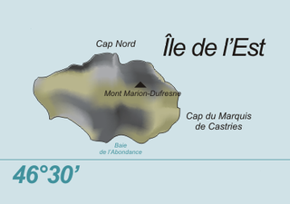
Île de l'Est, or East Island, is a part of the subantarctic archipelago of the Crozet Islands. With an area of 130 km2 (50 sq mi) it is the second largest island of the group. It is part of the French Southern and Antarctic Lands.
The Southern Indian Ocean Islands tundra is a tundra ecoregion that includes several subantarctic islands in the southern Indian Ocean.

Cape Washington is a prominent cape, 275 m, marking the south extremity of the cove which separates Wood Bay and Terra Nova Bay, in Victoria Land. It separates the Borchgrevink Coast to the north from the Scott Coast to the south. Discovered in 1841 by Captain James Clark Ross, Royal Navy, and named by him for Captain Washington, Royal Navy, who secretary of the Royal Geographical Society, 1836–40.

Île aux Cochons, or Pig Island, is an uninhabited island in the subantarctic Crozet Archipelago. With an area of 67 km2 (26 sq mi) it is the third largest island of the group. Administratively, it is part of the French Southern and Antarctic Lands.

Île de la Possession, or Possession Island, formerly Île de la Prise de Possession, is part of the Subantarctic Crozet Archipelago. Administratively, it is part of the French Southern and Antarctic Lands. It is an important nesting site for seabirds.

Île des Pingouins, or Penguin Island, is an uninhabited island in the subantarctic Crozet Archipelago of the southern Indian Ocean. With an area of only 3 km2 (1 sq mi) it is one of the smaller islands of the group. Administratively, it is part of the French Southern and Antarctic Lands. It is an important nesting site for seabirds.
Péninsule Jeanne d'Arc, also known as Presqu'île Jeanne d'Arc, is a peninsula of Grande Terre, the main island of the subantarctic Kerguelen archipelago in the southern Indian Ocean.
The Péninsule Loranchet, also known as Presqu'île Loranchet, is a peninsula of Grande Terre, the main island of the subantarctic Kerguelen archipelago in the southern Indian Ocean.
Les Îles Leygues or the Leygues Islands, occasionally called « les Îles Swain », are a group of small islands and islets that are part of the subantarctic Kerguelen archipelago, a French territory in the southern Indian Ocean.
The Îles Nuageuses comprise a group of small islands that are part of the Kerguelen archipelago, a French territory in the southern Indian Ocean. They are an important breeding spot for seabirds, especially penguins and albatrosses, and for fur seals.

The Southern Powell Island and adjacent islets Specially Protected Area is a 2688 ha site encompassing part of southern Powell Island in the South Orkney Islands of Antarctica. It includes neighbouring Christoffersen, Fredriksen, Michelsen and Grey Islands, along with some other (unnamed) offshore islets. It was designated an Antarctic Specially Protected Area because of its biological values as it supports many plants and animals that exemplify the natural ecology of the South Orkney Islands. It is also a breeding site for Antarctic fur seals.
Baie de l'Oiseau is a natural harbour in the Loranchet Peninsula, in the North-Western part of the island Grande Terre, part of the Kerguelen Islands. It was the landing site of the expedition under Yves de Kerguelen in 1772, and later of the expedition under James Cook in 1776. The site of Port-Christmas is part of the bay.
Coordinates: 49°35′S69°25′E / 49.583°S 69.417°E
| | This French Southern Territories location article is a stub. You can help Wikipedia by expanding it. |