Gallieni Massif

Last updated
Massif Gallieni
Gallieni Massif
Mont Ross (Kerguelen islands).jpg
View of the Gallieni Massif across the Morbihan Gulf
Highest point
Peak Mont Ross
Elevation 1,850 m (6,070 ft)
Coordinates 49°35′32″S69°29′45″E / 49.59222°S 69.49583°E / -49.59222; 69.49583 Coordinates: 49°35′32″S69°29′45″E / 49.59222°S 69.49583°E / -49.59222; 69.49583 [1]
Dimensions
Length18 km (11 mi)NW/SE
Width10 km (6.2 mi)NE/SW
Geography
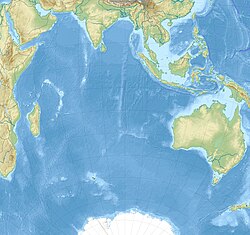
Indian Ocean laea relief location map.jpg
Red triangle with thick white border.svg
Grande Terre, Kerguelen( َFrance )
Geology
Type of rock Stratovolcano

The Gallieni Massif (French : Massif Gallieni) is a mountain range in Grande Terre, the main island of Kerguelen in the French Southern Territories zone of the Southern Indian Ocean. [2]
Contents

Geography

This range is located in the Gallieni Peninsula, fringing the southern coast. The highest point of the massif is the 1,850 metres (6,070 ft) high Mont Ross, a stratovolcano that is also the highest point of the Kerguelen Archipelago.

Other important summits of the range are 1,721 metres (5,646 ft) high Petit Ross, 1,063 metres (3,488 ft) high Dôme du Père Gaspard and the 995 metres (3,264 ft) high Grand Gendarme. The range also includes a number of glacial formations, among which the Buffon Glacier, the La Pilatte Glacier ,the Néves Glacier and the Sélé Glacier deserve mention. [3]

Topographic map of Kerguelen. Kerguelen Map.png
Topographic map of Kerguelen.
The Gallieni Massif seen from afar. Mont Ross, Kerguelen - PascalSubtil.jpg
The Gallieni Massif seen from afar.
NASA picture of southeastern Kerguelen with the massif on the right KerguelenMtRossNASA.jpg
NASA picture of southeastern Kerguelen with the massif on the right

See also

Related Research Articles

Heard Island and McDonald Islands Australian external territory and volcanic group of barren Antarctic islands

The Territory of Heard Island and McDonald Islands (HIMI) is an Australian external territory comprising a volcanic group of barren Antarctic islands, about two-thirds of the way from Madagascar to Antarctica. The group's overall size is 372 km2 (144 sq mi) in area and it has 101.9 km (63 mi) of coastline. Discovered in the mid-19th century, the islands have been an Australian territory since 1947 and contain the country's two only active volcanoes. The summit of one, Mawson Peak, is higher than any mountain on the Australian mainland. The islands lie on the Kerguelen Plateau in the Indian Ocean.

Kerguelen Islands French-administered subantarctic archipelago

The Kerguelen Islands, also known as the Desolation Islands, are a group of islands in the Antarctic constituting one of the two exposed parts of the Kerguelen Plateau, a large igneous province mostly submerged by the southern Indian Ocean. They are among the most isolated places on Earth, located more than 3,300 km (2,100 mi) from Madagascar, the nearest permanently populated location. The islands, along with Adélie Land, the Crozet Islands, Amsterdam and Saint Paul Islands, and France's Scattered Islands in the Indian Ocean, are part of the French Southern and Antarctic Lands and are administered as a separate district.

Aoraki / Mount Cook Mountain in the Southern Alps of New Zealand

Aoraki / Mount Cook is the highest mountain in New Zealand. Its height, as of 2014, is listed as 3,724 metres. It lies in the Southern Alps, the mountain range which runs the length of the South Island. A popular tourist destination, it is also a favourite challenge for mountain climbers. Aoraki / Mount Cook consists of three summits, from South to North the Low Peak, Middle Peak and High Peak. The summits lie slightly south and east of the main divide of the Southern Alps, with the Tasman Glacier to the east and the Hooker Glacier to the southwest.

Karakoram large mountain range spanning the borders between India, Pakistan and China

The Qaraqoram ,is a mountain range spanning the borders of India, Pakistan and China with the northwest extremity of the range extending to Afghanistan and Tajikistan. It begins in the Wakhan Corridor (Afghanistan) in the west and encompasses the majority of Gilgit-Baltistan (Pakistan) and extends into Ladakh (India) and the disputed Aksai Chin region controlled by China. It is the second highest mountain range in the world and part of the complex of ranges including the Pamir Mountains, the Hindu Kush and the Himalayan Mountains. The Qaraqoram has eight summits over 7,500 m (24,600 ft) height, with four of them exceeding 8,000 m (26,000 ft): K2, the second highest peak in the world at 8,611 m (28,251 ft), Gasherbrum I, Broad Peak and Gasherbrum II.

Zugspitze Highest peak of the Wetterstein Mountains (Eastern Alps)

The Zugspitze, at 2,962 m (9,718 ft) above sea level, is the highest peak of the Wetterstein Mountains as well as the highest mountain in Germany. It lies south of the town of Garmisch-Partenkirchen, and the Austria–Germany border runs over its western summit. South of the mountain is the Zugspitzplatt, a high karst plateau with numerous caves. On the flanks of the Zugspitze are three glaciers, including the two largest in Germany: the Northern Schneeferner with an area of 30.7 hectares and the Höllentalferner with an area of 24.7 hectares. The third is the Southern Schneeferner which covers 8.4 hectares.

Kebnekaise Swedens highest mountain

Kebnekaise is the highest mountain in Sweden. The Kebnekaise massif, which is part of the Scandinavian Mountains, has two main peaks. The glaciated southern peak used to be the highest at 2,120 metres (6,960 ft) above sea level, but has shrunk by 24 meters during the last 50 years, making the northern icefree peak at 2,096.8 metres (6,879 ft) the highest. Kebnekaise lies in Swedish Lapland, about 150 kilometres (93 mi) north of the Arctic Circle and west of Kiruna near the Kungsleden hiking trail between Abisko and Hemavan.

Aneto highest mountain in the Pyrenees

Aneto is the highest mountain in the Pyrenees and in Aragon, and Spain's third-highest mountain, reaching a height of 3,404 metres (11,168 ft). It stands in the Spanish province of Huesca, the northernmost of all three Aragonese provinces, 4 mi (6.4 km) south of the France–Spain border. It forms the southernmost part of the Maladeta massif. It is also still locally known as Pic de Néthou in French, that name and its variants having been in general use until the beginning of the 20th century.

Diablerets mountain in the Bernese Alps, Switzerland

The Diablerets are a huge ice-covered mountain massif of the Alps, culminating at the Sommet des Diablerets at 3,210 metres (10,530 ft) above sea level and straddling the border between the Swiss cantons of Vaud (VD) and Valais (VS). The northeastern part of the massif stretches also into the canton of Bern (BE).

Matthews Range

The Matthews Range, also known as the Lenkiyio Hills, is a range of mountains in Kenya, Africa.

Monte Rosa massif in Switzerland and Italy

Monte Rosa is a mountain massif located in the eastern part of the Pennine Alps. It is located between Italy and Switzerland (Valais). Monte Rosa is the second highest mountain in the Alps and western Europe, after Mont Blanc.

Grand Combin mountain massif in the western Pennine Alps

The Grand Combin is a mountain massif in the western Pennine Alps in Switzerland. With its 4,314 metres (14,154 ft) highest summit, the Combin de Grafeneire, it is one of the highest peaks in the Alps and the second most prominent of its range. The Grand Combin is also a large glaciated massif consisting of several summits, among which three are above 4000 metres.

Barre des Écrins mountain in the French Alps

The Barre des Écrins is a mountain in the French Alps with a peak at 4102m altitude. It is the highest peak of the Massif des Écrins and the Dauphiné Alps and the most southerly alpine peak in Europe that is higher than 4,000 m. It is the only 4,000 m mountain in France that lies outside the Mont Blanc Massif. Before the annexation of Savoy in 1860 it was the highest mountain in France.

Mont Blanc massif Mountain range in the Alps

The Mont Blanc massif is a mountain range in the Alps, located mostly in France and Italy, but also straddling Switzerland at its northeastern end. It contains eleven major independent summits, each over 4,000 metres (13,123 ft) in height. It is named after Mont Blanc, the highest point in western Europe and the European Union. Because of its considerable overall altitude, a large proportion of the massif is covered by glaciers, which include the Mer de Glace and the Miage Glacier – the longest glaciers in France and Italy, respectively.

Cook Ice Cap mountain in France

The Cook Ice Cap or Cook Glacier is a large ice cap in the Kerguelen Islands in the French Southern Territories zone of the far Southern Indian Ocean.

Hooker Island island

Hooker Island is one of the central islands of Franz Josef Land. It is located in the central area of the archipelago at 80.23°N 53.02°E. It is administered by the Arkhangelsk Oblast, Russia.

Mont Ross mountain in French Southern and Antarctic Lands France

Mont Ross is a stratovolcano, the highest mountain in the Kerguelen Islands at 1,850 metres (6,070 ft). It is located in the Gallieni Massif, at the end of the Gallieni Peninsula, east of Baie Larose on the main island of Grande Terre. The volcano is composed primarily of trachybasalt and was active during the late Pleistocene.

Watkins Range range in Greenland

The Watkins Range is Greenland's highest mountain range. It is located in King Christian IX Land, Sermersooq municipality.

Baie Larose

Baie Larose, or Larose Bay in English, is a bay of Grande Terre, the main island of the subantarctic Kerguelen archipelago, a French territory in the southern Indian Ocean. It is important as a breeding site for seabirds, especially penguins.

Îles Leygues archipelago in the Kerguelen Islands

The Îles Leygues, or Leygues Islands, also sometimes known as the Îles Swain, comprise a group of small islands and islets that are part of the subantarctic Kerguelen archipelago, a French territory in the southern Indian Ocean.

Geography of the Heard and McDonald Islands

The geography of the Heard Island and McDonald Islands (HIMI) refers to the geography of Heard Island and the McDonald Islands, one of the most remote places on earth. The islands belong to Australia and are located 4,000 kilometres (2,485.5 mi) southwest of the mainland in the Southern Ocean. These subantarctic islands were transferred to Australia by the United Kingdom in 1947. They lie between Madagascar and Antarctica.

References

  1. Google Earth
  2. "Massif Gallieni". Mapcarta. Retrieved 25 September 2016.
  3. "Glacier Buffon". Mapcarta. Retrieved 25 September 2016.