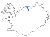
Eyjafjörður is one of the longest fjords in Iceland. It is located in the central north of the country, situated by the fjord is the country's fourth most populous municipality, Akureyri.

Grímsey Airport is an airport serving Grímsey, a small island 40 kilometres (25 mi) north of Iceland.

Patreksfjörður Airport or Patreksfjordur Airport is an airport serving Patreksfjörður, Iceland. The airport is across the fjord, 4.8 kilometres (3.0 mi) south of the town.
Siglufjörður Airport or Siglufjordur Airport is an airport serving Siglufjörður, Iceland.

Bíldudalur Airport is an airport serving Bíldudalur, a village in the Vesturbyggð municipality in the Westfjords of Iceland. The runway is 5 kilometres (3.1 mi) south-southeast of the village.

Bakki Airport is an airport on the southern coast of Iceland, used mainly for short-haul flights to and from the Westman Islands.

Selfoss Airport is an airport serving Selfoss, a town on the banks of Ölfusá river in the Árborg municipality in southern Iceland. Selfoss Airport is privately owned.

Gjögur Airport is an airport serving the small population of the Árneshreppur district in the Westfjords of north-west Iceland, on the coast of Húnaflói bay. It is staffed part-time by an AFIS controller, and only opens for Flugfélag Ernir flights, which are twice a week in the winter and once a week in the summer.

Sauðárkrókur Airport is an airport serving Sauðárkrókur, a village on the Skagafjörður bay in northern Iceland.

Djúpivogur Airport is an airport serving Djúpivogur, Iceland.

Norðfjörður Airport is an airport serving Neskaupstaður, Iceland. The town is on the Norðfjörður fjord.

Stykkishólmur Airport is an airport serving Stykkishólmur, Iceland.

Þingeyri Airport is an airport serving Þingeyri (Thingeyri), Iceland.

Fáskrúðsfjörður Airport is an airport serving Fáskrúðsfjörður, Iceland.

Fagurhólsmýri Airport is an airport serving Fagurhólsmýri, Iceland.

Kópasker Airport is an airport serving the coastal village of Kópasker, Iceland.

Breiðdalsvík Airport is an airport serving Breiðdalsvík, Iceland.

Grundarfjörður Airport is an airport serving Grundarfjörður, Iceland. The airport is on a peninsula 8 kilometres (5.0 mi) north of the town.

Hólmavík Airport is an airport serving Hólmavík, Iceland.


