
The geography of France consists of a terrain that is mostly flat plains or gently rolling hills in the north and west and mountainous in the south and the east.

USS Block Island (CVE-21/AVG-21/ACV-21) was a Bogue-class escort carrier for the United States Navy during World War II. She was the first of two escort carriers named after Block Island Sound off Rhode Island. Block Island was launched on 6 June 1942 by Seattle-Tacoma Shipbuilding Corporation in Tacoma, Washington, under a Maritime Commission contract; sponsored by Mrs. H. B. Hutchinson, wife of Commander Hutchinson; transferred to the United States Navy on 1 May 1942; and commissioned on 8 March 1943, Captain Logan C. Ramsey in command. Originally classified AVG-21, she became ACV-21 on 20 August 1942, and CVE-21 on 15 July 1943. She was named after Block Island, an island in Rhode Island east of New York.

Ózd is a town in Borsod-Abaúj-Zemplén county, Northern Hungary, 40 km (25 mi) from the county seat of Miskolc. Ózd is the second largest city in the county.

Putnok is a town in Borsod-Abaúj-Zemplén county, Northern Hungary. It lies 40 km (25 mi) away from Miskolc, between the Bükk Mountains and the river Sajó.

Northern Hungary is a region in Hungary. As a statistical region it includes the counties Borsod-Abaúj-Zemplén, Heves and Nógrád, but in colloquial speech it usually also refers to Szabolcs-Szatmár-Bereg county. The region is in the north-eastern part of the country. The region's centre and largest city is Miskolc.

Minoo Island is an Iranian island in the Khuzestan province, in southwestern Iran and is close to the city of Abadan. The city of Minushahr is on the island. The island is comprehended entirely by the Minu District of Khorramshahr County.

Angostura is a town and municipality in Antioquia Department, Colombia. Part of the subregion of Northern Antioquia.

Hosťová is a village and municipality in the Nitra District in western central Slovakia, in the Nitra Region.

Klárafalva is a village in Csongrád county, in the Southern Great Plain region of southern Hungary.

Shambles Glacier is a steep glacier 4 miles long and 6 miles wide, with very prominent hummocks and crevasses, flowing east between Mount Bouvier and Mount Mangin into Stonehouse Bay on the east side of Adelaide Island. It is the island's largest glacier, and provides an eastern outlet from the giant Fuchs Ice Piedmont which covers the entire western two-thirds of the island. In doing so, Shambles Glacier provides the largest 'gap' in Adelaide Island's north-south running mountain chain.

Găiceana is a commune in Bacău County, Romania. It is composed of four villages: Arini, Găiceana, Huțu and Popești.

Chrzczany is a village in the administrative district of Gmina Sochaczew, within Sochaczew County, Masovian Voivodeship, in east-central Poland. It lies approximately 7 kilometres (4 mi) east of Sochaczew and 46 km (29 mi) west of Warsaw.
Şükürlü is a village and municipality in the Jalilabad Rayon of Azerbaijan. It has a population of 385.
Olszewo is a village in the administrative district of Gmina Środa Wielkopolska, within Środa Wielkopolska County, Greater Poland Voivodeship, in west-central Poland. It lies approximately 4 kilometres (2 mi) south-east of Środa Wielkopolska and 35 km (22 mi) south-east of the regional capital Poznań.
Jákfalva is a village in Borsod-Abaúj-Zemplén County in northeastern Hungary.

Sáta is a village in Borsod-Abaúj-Zemplén County in northeastern Hungary. Sáta lies in the western part of the county, about 15 km from Ózd.
Kadila is a village in Vinni Parish, Lääne-Viru County, in northeastern Estonia.
The Miskolc Subregion is a subregion in Northern Hungary. Its area is 1058 km². With a population of 267,582 (2009) it is the second most populated subregion in Hungary and the most populated in Borsod-Abaúj-Zemplén county. Its centre and largest city is Miskolc; there are five other towns – Sajószentpéter, Felsőzsolca, Alsózsolca, Emőd, Nyékládháza – and thirty-four villages belonging to the subregion.
Kazincbarcika is a district in north-western part of Borsod-Abaúj-Zemplén County. Kazincbarcika is also the name of the town where the district seat is found. The district is located in the Northern Hungary Statistical Region.

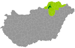
Ózd is a district in western part of Borsod-Abaúj-Zemplén County. Ózd is also the name of the town where the district seat is found. The district is located in the Northern Hungary Statistical Region.


