The geography of Switzerland encompasses the geographical features of Switzerland, a mountainous and landlocked country located in Western and Central Europe. It is surrounded by 5 countries: Austria and Liechtenstein to the east, France to the west, Italy to the south and Germany to the north. Switzerland has a maximum north–south length of 220 kilometres (140 mi) and an east–west length of about 350 kilometres (220 mi).

The Rwenzori Mountains, previously called the "Ruwenzori Range", is a mountain range of eastern equatorial Africa, located on the border between Uganda and the Democratic Republic of the Congo (DRC). These mountains support glaciers and are one source of the river Nile.
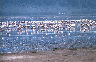
The Rift Valley lakes are a group of lakes in the East African Rift that runs north-south through the eastern side of the African continent, from Ethiopia in the north to Malawi in the south. These lakes include some of the oldest, largest, and deepest lakes in the world. Many are freshwater ecoregions of great biodiversity, while others are alkaline "soda lakes" supporting highly specialised organisms.

Femunden is Norway's third largest lake and the second largest natural lake in Norway. It is located in Hedmark and Trøndelag counties in Norway, just 13 kilometres (8.1 mi) west of the border with Sweden. The lake lies primarily in the municipality of Engerdal and also smaller parts are located in the municipalities of Os (Hedmark) and Røros (Trøndelag). Femundsmarka National Park borders the northeastern part of the lake.
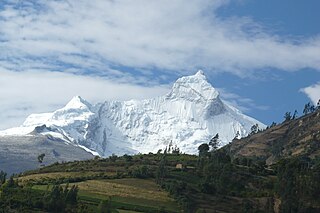
The Cordillera Blanca is a mountain range in Peru that is part of the larger Andes range and extends for 200 kilometres (124 mi) between 8°08' and 9°58'S and 77°00' and 77°52'W, in a northwesterly direction. It includes several peaks over 6,000 metres (19,690 ft) high and 722 individual glaciers. The highest mountain in Peru, Huascarán, at 6,768 metres (22,205 ft) high, is located there.

Lake Margaret is a concrete-faced gravity dam with a uncontrolled spillway across the Yolande River, located on the north side of Mount Sedgwick, in the West Coast Range, West Coast of Tasmania, Australia.

Eucumbene Dam is a major gated earthfill embankment dam with an overflow ski-jump and bucket spillway with two vertical lift gates across the Eucumbene River in the Snowy Mountains of New South Wales, Australia. The dam's main purpose is for the generation of hydro-power and is one of the sixteen major dams that comprise the Snowy Mountains Scheme, a vast hydroelectricity and irrigation complex constructed in south-east Australia between 1949 and 1974 and now run by Snowy Hydro.

Tunnsjøen is a lake in the municipalities of Røyrvik and Lierne in Trøndelag county, Norway. The 100.18-square-kilometre (38.68 sq mi) lake lies just south of the large lake Limingen, and just west of the border with Sweden. It is 358 metres (1,175 ft) above sea level and has a volume of 8.68 cubic kilometres (2.08 cu mi). The deepest part of the lake is 220 metres (720 ft) deep. It is the seventh largest lake in Norway.

Limingen is a lake in the municipalities of Røyrvik and Lierne in Trøndelag county, Norway. It is the eighth-largest lake in the country. The lake lies 418 metres (1,371 ft) above sea level and has an area of 93 square kilometres (36 sq mi). At the deepest point, it is 192 metres (630 ft) deep and averages about 87 metres (285 ft) deep. The lake has a volume of 8.34 cubic kilometres (2.00 cu mi) and is located just north of the large lake Tunnsjøen. The border with Sweden lies about 725 metres (0.5 mi) east of the lake.

The Albertine Rift is the western branch of the East African Rift, covering parts of Uganda, the Democratic Republic of the Congo (DRC), Rwanda, Burundi and Tanzania. It extends from the northern end of Lake Albert to the southern end of Lake Tanganyika. The geographical term includes the valley and the surrounding mountains.
Orrevatnet is a lake in the municipality of Klepp in Rogaland county, Norway. The 8.04-square-kilometre (3.10 sq mi) lake is the largest lake in Jæren. The lake sits about 4 metres (13 ft) above sea level and it is situated along the seashore. The 500-to-2,500-metre wide sandy beach strip of land that separates the lake from the sea is home to one of Norway's longest sand beaches, Orrestranda. The village of Orre lies on this strip of land to the southeast of the lake.

Holskardvatnet is a lake in the municipality Vik in Sogn og Fjordane county, Norway. It is located just less than 100 metres (330 ft) north of the municipality border with Modalen in Hordaland county. The lake is 20 kilometres (12 mi) south of the village of Ortnevik in neighboring Høyanger Municipality, about 13 kilometres (8.1 mi) southwest of the village of Arnafjord, and about 28 kilometres (17 mi) southwest of the municipal center of Vikøyri. The 4.81 square kilometres (1.86 sq mi) lake is located at an elevation of 845 metres (2,772 ft) above sea level.

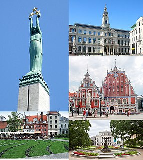
Jugla is a neighbourhood of Riga, the capital of Latvia. It is located west of the Lake Jugla and southeast of the Lake Ķīšezers. Jugla is bordered by Čiekurkalns, Mežciems and Teika to the west, Dreiliņi to the southwest, Brekši to the southeast and Bukulti to the east.

Čiekurkalns is neighbourhood of Northern District in Riga, the capital of Latvia. It is located on the southwestern shore of Lake Ķīšezers

Apolobamba(Cordillera Apolobamba) is a mountain range in the South American Andes.

Mīlgrāvis is a neighbourhood of Northern District in Riga, the capital of Latvia. It is located on the western shore of Lake Ķīšezers.

SOIUSA is a proposal for a new classification system of the Alps from the geographic and toponomastic point of view. It was designed by Sergio Marazzi, Italian researcher and author of the Orographic Atlas of the Alps SOIUSA. His book was presented with the patronage of the Italian Alpine Club on 23 Jan 2006, but has yet to receive any formal acceptance.

The Opawica River is a tributary of the Waswanipi River, which is a tributary of Matagami Lake which in turn flows into the Nottaway River which flows into the south of James Bay. The Opawica River flows in the municipality of Eeyou Istchee Baie-James (municipality), in the administrative region of Nord-du-Québec, in Quebec, the Canada.
The Mégiscane River is a tributary of Parent Lake (Abitibi). It flows in the Northwest of Quebec, in Canada, in the administrative regions of: