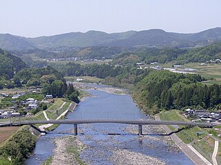
The Ōno River is a river that originates in Ōita Prefecture, Japan. After running through the southern and central portions of Ōita Prefecture, it runs through the eastern part of Kumamoto Prefecture and the northern part of Miyazaki Prefecture.

Ōita Station is a JR Kyushu railway station located in Ōita, Ōita Prefecture, Japan.
National Route 197 is a Japanese national highway running on the islands of Kyūshū and Shikoku. It originates at the junction with Routes 10 and 210 in Ōita, Ōita and terminates at the junction with Route 56 in Susaki, Kōchi. The route is 223.1 kilometers long but is interrupted between Saganoseki area of Ōita, Ōita and Ikata, Ehime because of the Hōyo Strait, and traffic between the two islands is carried by a ferry between the two towns. Though the gap is less than 15 km at the strait's narrowest point, there are currently no plans to bridge the gap.

Beppu Station is the main railway station for the city of Beppu in Ōita Prefecture, Japan, which is famous for its onsen. It is situated on the Nippō Main Line. The station, and all trains serving it, are operated by JR Kyūshū.
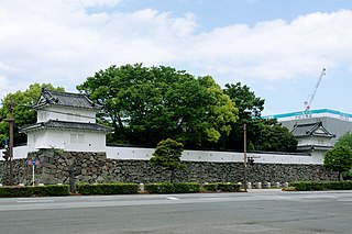
Funai Castle is a 16th-century castle, located in Ōita city, Ōita Prefecture, Japan. It was built by Ōtomo Sōrin in 1562, who owned much of the surrounding Kyūshū island. The castle was originally built with several turrets (yagura), all of which were burnt down with the three story donjon in 1743. The covered bridge that led to the castle over its moat, as well as several turrets, were rebuilt in the 20th century. Original remains include part of the wall and the moat.

Yufuin Station is a railway station on the Kyudai Main Line in Yufuin, Ōita, Japan, operated by Kyushu Railway Company.

Hakusui Dam (白水ダム) is a concrete gravity dam on the upper reaches of the Ōno River in Taketa, Ōita Prefecture, Japan. It was constructed in 1938, and is 86 m wide and 14 m tall.
Nippon Bunri University is a private university in Ōita, Ōita, Japan. The school was established in 1967 and adopted its present name in 1982.
Oita University of Nursing and Health Sciences is a public university in Ōita, Ōita, Japan, established in 1998.
Oita Junior College is a private junior college in Ōita, Ōita, Japan, established in 1964.

Oita Prefectural College of Arts and Culture is a public junior college in Ōita, Ōita Prefecture, Japan, established in 1961. The university has departments in art, music, global studies, and information and communication.

Heisei Ozeki Dam is a dam on the Yamakuni River between Kōge, Fukuoka Prefecture and Nakatsu, Ōita Prefecture in Japan.
Ōita Hōfu High School is a Junior high school and High school in Ōita, Ōita, Japan. The school opened in April 1986, and the junior high school was added in April 2007.

Nakatsu Station is a railway station on the Nippō Main Line operated by Kyūshū Railway Company in Nakatsu, Ōita, Japan.

Oita Athletic Stadium (大分市営陸上競技場) is an athletic stadium in Oita, Oita, Japan.

Hiju Dam is a dam in Kusu, Ōita Prefecture, Japan, and it was completed in 1969. The rock-fill dam is characterized by radial gates of the gate 3, which supplies water for agriculture and farmland.

Hisashi Dam is a dam in the Ōita Prefecture, Japan, completed in 1979. It is an Embankment Dam with the purpose of being an irrigational and industrial water dam. The dam is 40 metres high and retains 4 800 000 m³ of water over a 263 metre crest length. The volume of the dam is 431 000 m³ and the surface area of lake Hisashi is 370 000 m².

Inaba Dam is a dam in Taketa, Ōita Prefecture, Japan, completed in 2010.

Kitagawa Dam is a dam in the Saiki, Ōita, Japan, completed in 1962. It spans the Kita River, a class A river, in the Gokase River drainage system. It is managed by Ōita Prefecture, and it is an 82.0 meter tall concrete arch dam. It is the largest dam in the Gokase River drainage system, and it was built with government subsidies with the goal of flood control and hydroelectric power generation for the Kita River basin. The man-made lake formed by the dam is the largest such reservoir of any dam administered by the prefecture, but it is simply called the Kitagawa Dam Lake and has no nickname. Despite that in 2005 it was selected by the Dam Waters Environment Development Center Foundation as one of the top one hundred reservoirs.

The Ōita Prefectural Museum of History opened in Usa, Ōita Prefecture, Japan in 1998, replacing the Usa Fudoki-no-Oka (宇佐風土記の丘) of 1981. It is one of Japan's many museums which are supported by a prefecture.


