Kitagawa Dam

Last updated
Kitagawa Dam
Kitagawa-2757-r1.JPG
Location Ōita Prefecture, Japan
Construction began 1958
Opening date 1962
Operator(s) Ōita Prefecture
Dam and spillways
Type of dam Concrete arch dam
Height 82.0 m
Length 188.3 m
Dam volume 66,000 m³
Reservoir
Catchment area 211.0 km²
Surface area 200.0 ha
Power Station
Annual generation 25,100kW

Kitagawa Dam (Japanese : 北川ダム) is a dam in the Saiki, Ōita, Japan, completed in 1962. [1] It spans the Kita River, a class A river, in the Gokase River drainage system. It is managed by Ōita Prefecture, and it is an 82.0 meter tall concrete arch dam. It is the largest dam in the Gokase River drainage system, and it was built with government subsidies with the goal of flood control and hydroelectric power generation for the Kita River basin. The man-made lake formed by the dam is the largest such reservoir of any dam administered by the prefecture, but it is simply called the Kitagawa Dam Lake and has no nickname. Despite that in 2005 it was selected by the Dam Waters Environment Development Center Foundation as one of the top one hundred reservoirs.

Japanese is an East Asian language spoken by about 128 million people, primarily in Japan, where it is the national language. It is a member of the Japonic language family, and its relation to other languages, such as Korean, is debated. Japanese has been grouped with language families such as Ainu, Austroasiatic, and the now-discredited Altaic, but none of these proposals has gained widespread acceptance.

Dam A barrier that stops or restricts the flow of surface or underground streams

A dam is a barrier that stops or restricts the flow of water or underground streams. Reservoirs created by dams not only suppress floods but also provide water for activities such as irrigation, human consumption, industrial use, aquaculture, and navigability. Hydropower is often used in conjunction with dams to generate electricity. A dam can also be used to collect water or for storage of water which can be evenly distributed between locations. Dams generally serve the primary purpose of retaining water, while other structures such as floodgates or levees are used to manage or prevent water flow into specific land regions. The earliest known dam is the Jawa Dam in Jordan, dating to 3,000 BC.

Saiki, Ōita City in Kyushu, Japan

Saiki is a city located in Ōita Prefecture, Japan. The city was founded on April 29, 1941.

Summary

The Kita River originates in Ōita Prefecture and flows into the Sea of Hyūga off Miyagi Prefecture after joining its tributary Nakadake River, and along the way flows close to the border of the two prefectures, and Kitagawa Dam, built to dam this river, was the first concrete arch dam in Ōita Prefecture. According to Ōita Electric Power Department, the dam was built to be a multipurpose dam for flood control and power generation, and the height of the headwaters was low at 285 meters, and to function in the Kita River which has a narrow grade, the dam functions with an unusually narrow height difference.

Sea of Hyūga

The Hyuga-nada Sea is the part of the Pacific Ocean that lies off the eastern shore of the island of Kyushu, to the south-west of the island of Honshu, off the south coast of Japan. Its name is derived from the former province of Hyūga, which corresponded to the prefecture of Miyazaki before the Meiji Restoration.

Miyagi Prefecture Prefecture of Japan

Miyagi Prefecture is a prefecture in the Tōhoku region of Japan. The capital is Sendai.

The portion of Kita River upstream of where Nakadake River joins it is known as Tashiro River. A stone arched bridge built across the Tashiro River in 1908, directly upstream of where the rivers merge, is submerged in the reservoir. The stone bridge is 10 meters from the bottom of the lake, so it is visible only from the summer dry season until the reservoir becomes full when the rainy season starts or a typhoon comes.

Kitagawa Dam's reservoir has been chosen as one of the top 100 reservoirs. On the left bank of the reservoir is Japan National Route 326, the spot where the Nakadake River tributary flows into Kita River has a local folk song called "Ume no Utagenka", and the Utagenka Bridge located there is connected to that song, and in the vicinity of the bridge is the Ume Rest Area. The vicinity of the dam is the natural habitat of the mountain hawk-eagle, and in 1981 the prefecture designated it as a protected wildlife area.

Japan National Route 326 road in Japan

National Route 326 is a national highway of Japan connecting Nobeoka, Miyazaki and Bungo-ōno, Ōita in Japan, with a total length of 68.3 km (42.44 mi).

Mountain hawk-eagle species of bird

The mountain hawk-eagle or, alternately, Hodgson's hawk-eagle is a large bird of prey native to Asia. The latter name is in reference to the naturalist, Brian Houghton Hodgson, who described the species after collecting one himself in the Himalayas. A less widely recognized common English name is the feather-toed eagle. Like all eagles, it is in the family Accipitridae. Its feathered tarsus marks this species as a member of the Aquilinae subfamily. It is a confirmed breeding species in the northern part of the Indian subcontinent, from India, Nepal through Bangladesh to Thailand, Taiwan and Japan, although its distribution could be wider still as breeding species. Like other Asian hawk-eagles, this species was earlier treated under the genera of Spizaetus but genetic studies have shown this group to be paraphyletic, resulting in the Old World members being placed in Nisaetus and separated from the New World species. As is typical of hawk-eagles, the mountain hawk-eagle is a forest dwelling opportunistic predator who readily varies its prey selection between birds, mammals and reptiles along with other vertebrates. Although classified currently as a least-concern species due its persistence over a rather wide distribution, this species is often quite rare and scarce and seems to be decreasing, especially in response to large-scale habitat degradation and deforestation.

Related Research Articles

Cowlitz River river in the United States of America

The Cowlitz River is a river in the state of Washington in the United States, a tributary of the Columbia River. Its tributaries drain a large region including the slopes of Mount Rainier, Mount Adams, and Mount St. Helens.

Elk River (Tennessee River) tributary of the Tennessee River in the U.S. states of Tennessee and Alabama

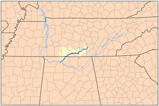
The Elk River is a tributary of the Tennessee River in the U.S. states of Tennessee and Alabama. The river is about 195 miles (314 km) long.

River Lee river in Ireland

The River Lee is a river in Ireland. It rises in the Shehy Mountains on the western border of County Cork and flows eastwards through Cork, where it splits in two for a short distance, creating an island on which Cork's city centre is built, and empties into the Celtic Sea at Cork Harbour on the south coast, one of the largest natural harbours in the world. The catchment area of the River Lee is 1,253 km2. The long-term average flow rate of the River Lee is 40.4 Cubic Metres per second (m3/s)

Yuba River river in the United States of America

The Yuba River is a tributary of the Feather River in the Sierra Nevada and eastern Sacramento Valley, in the U.S. state of California. The main stem of the river is about 40 miles (64 km) long, and its headwaters are split into three major forks. The Yuba River proper is formed at the confluence of the North Yuba and Middle Yuba Rivers, with the South Yuba joining a short distance downstream. Measured to the head of the North Yuba River, the Yuba River is just over 100 miles (160 km) long.

Bridge River watercourse in Canada

The Bridge River is an approximately 120 kilometres (75 mi) long river in southern British Columbia. It flows south-east from the Coast Mountains. Up until 1961, it was a major tributary of the Fraser River, entering that stream about six miles upstream from the town of Lillooet; its flow, however, was near-completely diverted into Seton Lake with the completion of the Bridge River Power Project, with the water now entering the Fraser just south of Lillooet as a result.

Qing River river in Peoples Republic of China

The Qing River is a right (southern) tributary of the Yangtze River in Hubei province of south-central China.

Piscataquog River river in the United States of America

The Piscataquog River is a 34.7-mile-long (55.8 km) river located in southern New Hampshire in the United States. It is a tributary of the Merrimack River, which flows to the Gulf of Maine.

Croton Falls Reservoir

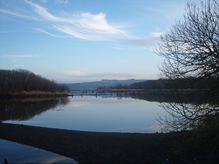
The Croton Falls Reservoir is a reservoir in the New York City water supply system in the Putnam County, New York townships of Carmel, and Southeast, roughly 50 miles (80 km) north of New York City. Part of the system's Croton Watershed, it was formed by impounding the West Branch and Middle Branch of the Croton River, tributaries of the Croton River, which flows into the Hudson River.

Horse Mesa Dam concrete thin arch dam located in the Superstition Mountains

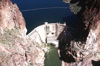
The Horse Mesa Dam is a concrete thin arch dam located in the Superstition Mountains, northeast of Phoenix in Maricopa County, Arizona.

Kawachi Dam

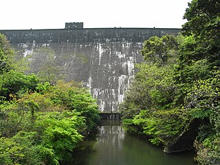
Kawachi Dam is a dam in Yahata Higashi, KitaKyushu City, Fukuoka Prefecture, Japan. It was built from stone and mortar to sustain water flow for local steel mills between 1919 and 1927. It was once referred to as the "Orient's best dam". As for Minamikawachi Bridge, completed in 2006, it is a part of Kitakyushu Seminational Park and has been a national industrial heritage since 2007. A mountain hike begins from these sites. Minami-Kawachi bridge on the reservoir was classified as Japanese Important Cultural Property in 2006.

Tashiro Dam

The Tashiro Dam is a dam on the Ōi River in Aoi-ku, Shizuoka, Shizuoka Prefecture on the island of Honshū, Japan. It was the first concrete gravity dam to be constructed on the Ōi River, and has a hydroelectric power generating station owned by the Tokyo Electric Power Company.

Fuchu Dam

Fuchu Dam is a dam in Fuchu Town, Sakaide, Kagawa, Japan, completed in 1966. It dams the Aya River in the Aya River drainage system.

Nanairo Dam dam in Mie Prefecture, Japan

The Nanairo Dam is a concrete gravity-arch dam located in Kumano, Mie Prefecture, Japan. The dam crosses the Kitayama River, a tributary of the Kumano River near the border of Mie Prefecture with Wakayama Prefecture.

Tsukabaru Dam

Tsukabaru Dam is a concrete gravity dam built on the Mimi River for hydro electric power generation in the Miyazaki Prefecture in Japan. The dam, built by the Kyushu Electric Power Co, Ltd. in 1938, was commissioned only in 1993. When built to a height of 87 m (285 ft) it was the highest gravity type dam in Japan, only to be surpassed later by the Kamishiba Dam raised in the uppermost reaches of the Mimi River.

Daecheong Dam dam in South Korea

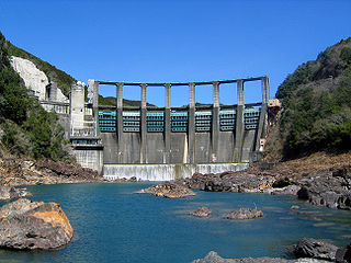
The Daecheong Dam is a combination concrete gravity and embankment dam on the Geum River, 16 km (10 mi) north of Daejeon in South Korea. The multi-purpose dam provides benefits of flood control, water supply and hydroelectric power generation. Construction on the dam began in 1975 and was formally commissioned on 1 December 1980. The 72 m (236 ft) high rock-fill dam has a central clay core and has created a reservoir with storage of 1,490,000,000 m3 (1,207,963 acre⋅ft).

Kosasthalaiyar River, also known as Kortalaiyar, is one of the three rivers that flow in the Chennai metropolitan area.

Ōitagawa Dam

Ōitagawa Dam is a dam under construction in the Ōita Prefecture, Japan, scheduled for completion in 2017.

Roaring Brook (Lackawanna River tributary) river in Pennsylvania, United States of America

Roaring Brook is a tributary of the Lackawanna River in Lackawanna County, Pennsylvania, in the United States. It is approximately 21 miles (34 km) long and flows through Covington Township, Madison Township, Moscow, Roaring Brook Township, Elmhurst Township, Dunmore, and Scranton. The watershed of the stream has an area of 56.3 square miles (146 km2). Its named tributaries include Little Roaring Brook, Rock Bottom Creek, White Oak Run, Van Brunt Creek, Bear Brook, and East Branch Roaring Brook. It has a high level of water quality for much of its length. However, it is affected by abandoned mining land, stormwater, and other impacts in its lower reaches. Reservoirs in the watershed include the Hollister Reservoir, the Elmhurst Reservoir, and others. The stream also flows through the Nay Aug Gorge and passes over the Nay Aug Falls, which are on the National Register of Geologic Landmarks. It flows through a concrete channel in its lower reaches. The topography of the watershed contains rolling hills in its upper reaches and the mountainous land of the Moosic Mountains in its lower reaches.

Leggetts Creek river in the United States of America

Leggetts Creek is a tributary of the Lackawanna River in Lackawanna County, Pennsylvania, in the United States. It is approximately 9.0 miles (14.5 km) long and flows through Scott Township, South Abington Township, and Scranton. The watershed of the creek has an area of 18.5 square miles (48 km2). The creek has three named tributaries: Leach Creek, Clover Hill Creek, and Summit Lake Creek. Leggetts Creek is considered to be impaired due to urban development problems, but is not affected by acid mine drainage. The creek is fairly alkaline and is a perennial stream. Its headwaters are in wetlands outside of the Lackawanna Valley and it flows through a water gap known as Leggetts Gap or The Notch. Major lakes in the watershed include the Griffin Reservoir, Summit Lake, and Maple Lake. The creek is a source of flooding in South Abington Township.

References

Coordinates: 32°47′26″N131°36′28″E / 32.79056°N 131.60778°E / 32.79056; 131.60778

Geographic coordinate system Coordinate system

A geographic coordinate system is a coordinate system that enables every location on Earth to be specified by a set of numbers, letters or symbols. The coordinates are often chosen such that one of the numbers represents a vertical position and two or three of the numbers represent a horizontal position; alternatively, a geographic position may be expressed in a combined three-dimensional Cartesian vector. A common choice of coordinates is latitude, longitude and elevation. To specify a location on a plane requires a map projection.