
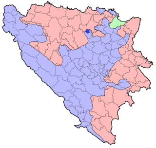
The Zenica-Doboj Canton is one of 10 cantons of the Federation of Bosnia and Herzegovina in Bosnia and Herzegovina. The capital is Zenica.

The Central Bosnia Canton is one of 10 cantons of the Federation of Bosnia and Herzegovina in Bosnia and Herzegovina.

The West Herzegovina Canton is one of the cantons of the Federation of Bosnia and Herzegovina. The West Herzegovina Canton is in the Herzegovina region in the southwest of Bosnia and Herzegovina. Its seat of government is in Široki Brijeg, while other municipalities within the Canton are Grude, Ljubuški and Posušje. It has 94,898 inhabitants, of whom more than 98% are ethnic Croats.

Zavidovići is a town and municipality located in Zenica-Doboj Canton of the Federation of Bosnia and Herzegovina, an entity of Bosnia and Herzegovina. It is situated in central Bosnia and Herzegovina, located between Doboj and Zenica on the confluence of rivers Bosna, Krivaja and Gostović. It sits in a valley surrounded by many mountains of which the largest is Klek. As of 2013, it has a population of 40,272 inhabitants.
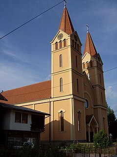
Žepče is a town and municipality located in Zenica-Doboj Canton of the Federation of Bosnia and Herzegovina, an entity of Bosnia and Herzegovina. It is situated in central Bosnia and Herzegovina, between Doboj and Zenica. As of 2013, it has a population of 31,582 inhabitants.
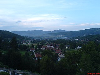
Busovača is a town and municipality located in Central Bosnia Canton of the Federation of Bosnia and Herzegovina, an entity of Bosnia and Herzegovina. It is located 60 km (37 mi) from Sarajevo, 21 km (13 mi) from Zenica, and 30 km (19 mi) from Travnik.

Olovo is a town and municipality located in Zenica-Doboj Canton of the Federation of Bosnia and Herzegovina, an entity of Bosnia and Herzegovina. It is situated about 50 kilometers northeast of the capital city of Sarajevo.
Usora is a village and municipality located in Zenica-Doboj Canton of the Federation of Bosnia and Herzegovina, an entity of Bosnia and Herzegovina. It borders with Doboj and Tešanj municipality, and it is named after the Usora River.

Doboj South is a village and municipality located in Zenica-Doboj Canton of the Federation of Bosnia and Herzegovina, an entity of Bosnia and Herzegovina. It borders with the municipality of Doboj, which is a part of Republika Srpska entity.

Doboj East is a town and municipality located in Tuzla Canton of the Federation of Bosnia and Herzegovina, an entity of Bosnia and Herzegovina. It was created after the Dayton peace agreement in 1998 by seceding from the municipality of Doboj.

Dobretići is a village and municipality located in Central Bosnia Canton of the Federation of Bosnia and Herzegovina, an entity of Bosnia and Herzegovina. It is one of the youngest and smallest municipalities in Bosnia and Herzegovina hence being one of the poorest municipalities as well. Before the Bosnian War municipality of Dobretići was part of municipality Skender Vakuf.

Petrovo is a town and municipality located in Republika Srpska, an entity of Bosnia and Herzegovina. As of 2013, the town has a population of 2,322 inhabitants, while the municipality has 6,474 inhabitants.
Stožer is a mountain in the municipality of Bugojno, Bosnia and Herzegovina. It has an altitude of 1,758 metres (5,768 ft).
Plazenica is a mountain in the municipality of Kupres, Bosnia and Herzegovina. It has an altitude of 1,765 metres (5,791 ft).
Ujilica is a mountain in the municipality of Grahovo, Bosnia and Herzegovina. It has an altitude of 1,654 metres (5,427 ft).
Žep is a mountain in the municipality of Han Pijesak, Bosnia and Herzegovina. It has an altitude of 1,537 metres (5,043 ft).
Staretina is a mountain in the municipality of Livno, Bosnia and Herzegovina. It has an altitude of 1,633 metres (5,358 ft).
Javor is a mountain in the municipality of Nevesinje, Bosnia and Herzegovina. It has an altitude of 1,553 metres (5,095 ft).
Ljubuša is a mountain in the municipality of Tomislavgrad, Bosnia and Herzegovina. It has an elevation of 1,797 metres (5,896 ft).
Kruščica or Kruščićka planina is a mountain in Central Bosnia, positioned between municipalities of Vitez and Busovača, Bosnia and Herzegovina. It is bordered by the town of Vitez and Vjetrenice mountain range to the north, Vilenica mountain to the northeast, Radovan mountain to the east, Vranica mountain range to the south and Busovačka planina to the west. It has an altitude of 1,673 metres (5,489 ft).


