Related Research Articles
Year 1459 (MCDLIX) was a common year starting on Monday of the Julian calendar.

Year 1509 (MDIX) was a common year starting on Monday of the Julian calendar.
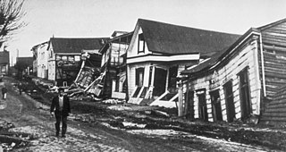
The 1960 Valdivia earthquake and tsunami or the Great Chilean earthquake on 22 May 1960 was the most powerful earthquake ever recorded. Most studies have placed it at 9.4–9.6 on the moment magnitude scale, while some studies have placed the magnitude lower than 9.4. It occurred in the afternoon, and lasted 10 minutes. The resulting tsunamis affected southern Chile, Hawaii, Japan, the Philippines, eastern New Zealand, southeast Australia, and the Aleutian Islands.

Francisco de Ulloa was a Spanish explorer who explored the west coast of present-day Mexico and the Baja California Peninsula under the commission of Hernán Cortés. Ulloa's voyage was among the first to disprove the cartographic misconception of the existence of the Island of California.
The year 1573 in science and technology included many events, some of which are listed here.

Juan de la Cosa was a Castilian navigator and cartographer, known for designing the earliest European world map which incorporated the territories of the Americas discovered in the 15th century. De la Cosa was the owner and master of the Santa María, and thus played an important role in the first and second voyage of Christopher Columbus to the West Indies.

The Casa de Contratación or Casa de la Contratación de las Indias was established by the Crown of Castile, in 1503 in the port of Seville as a crown agency for the Spanish Empire. It functioned until 1790, when it was abolished in a government reorganization.
Megathrust earthquakes occur at convergent plate boundaries, where one tectonic plate is forced underneath another. The earthquakes are caused by slip along the thrust fault that forms the contact between the two plates. These interplate earthquakes are the planet's most powerful, with moment magnitudes (Mw) that can exceed 9.0. Since 1900, all earthquakes of magnitude 9.0 or greater have been megathrust earthquakes.

The Puerto Rico Trench is located on the boundary between the Caribbean Sea and the Atlantic Ocean. The oceanic trench, the deepest in the Atlantic, is associated with a complex transition between the Lesser Antilles subduction zone to the south and the major transform fault zone or plate boundary, which extends west between Cuba and Hispaniola through the Cayman Trough to the coast of Central America.

Matthias Ringmann (1482–1511), also known as Philesius Vogesigena was an Alsatian German humanist scholar and cosmographer. Along with cartographer Martin Waldseemüller, he is credited with the first documented usage of the word America, on the 1507 map Universalis Cosmographia in honour of the Italian explorer Amerigo Vespucci.

Diogo Ribeiro was a Portuguese cartographer and explorer who worked most of his life in Spain, where he was known as Diego Ribero. He worked on the official maps of the Padrón Real from 1518 to 1532. He also made navigation instruments, including astrolabes and quadrants.

Santoña is a town in the eastern coast of the autonomous community of Cantabria, on the north coast of Spain. It is situated by the bay of the same name. It is 45 kilometres (28 mi) from the capital Santander. Santoña is divided into two zones, an urban plain, and a mountainous area, with Mount Buciero at its eastern limit, and Brusco and the beach of Berria to the north. The beach of San Martin comprises its south limit and the fishing harbor and marsh area its western limit.
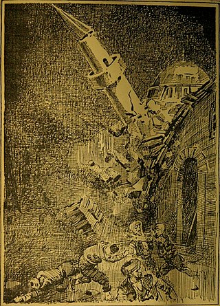
The 1509 Constantinople earthquake or historically Kıyamet-i Sugra occurred in the Sea of Marmara on 10 September 1509 at about 22:00. The earthquake had an estimated magnitude of 7.2 ± 0.3 on the surface-wave magnitude scale. A tsunami and 45 days of aftershocks followed the earthquake. The death toll of this earthquake is poorly known; estimates range between 1,000 and 13,000.

Champel is a neighborhood in the city of Geneva, Switzerland.

Bermeja is a phantom islet lying off the north coast of the Yucatán peninsula according to several maps of the Gulf of Mexico from the 16th to the 20th centuries. Despite being located somewhat precisely in relation to neighboring islands by notable Spanish cartographers of the 16th century, the island was not found in a 1997 survey, nor in an extensive 2009 study conducted by the National Autonomous University of Mexico (UNAM) on behalf of the Mexican Chamber of Deputies. Interest in the island arose in late 2008, fueled by the fact that if such an island existed, it would be important for determining the boundaries for exploitation rights of oil in Hoyos de Dona in the Gulf of Mexico.

This list of 20th-century earthquakes is a list of earthquakes of magnitude 6 and above that occurred in the 20th century. Sone smaller events which nevertheless had a significant impact are also included. After 1900 most earthquakes have some degree of instrumental records and this means that the locations and magnitudes are more reliable than for earlier events.
Americus is an unincorporated community in Montgomery County, in the U.S. state of Missouri.

The 1766 Istanbul earthquake was a strong earthquake with epicenter in the eastern part of the Sea of Marmara, in the Çınarcık Basin which occurred in the early hours of Thursday morning, 22 May 1766. The earthquake had an estimated magnitude of 7.1 on the surface wave magnitude scale, and caused effects in a vast area extending from Izmit to Rodosto. In this area, the earthquake was followed by a tsunami which caused significant damage. The earthquake of 1766 was the last major earthquake to rock Constantinople because of a rupture of the North Anatolian Fault in the Marmara region.
References
- ↑ Ambraseys, N. N. (December 2001). "The Earthquake of 1509 in the Sea of Marmara, Turkey, Revisited" (PDF). Bulletin of the Seismological Society of America. 91 (6): 1397. Bibcode:2001BuSSA..91.1397A. doi:10.1785/0120000305.[ permanent dead link ]