The 2003 Colima earthquake occurred on 21 January with a moment magnitude of 7.6 and a maximum Mercalli intensity of VIII (Severe). The epicenter was located on the Pacific coast in the Mexican state of Colima. The earthquake was felt as far away as Mexico City and in southern parts of the United States.
Episodic tremor and slip (ETS) is a seismological phenomenon observed in some subduction zones that is characterized by non-earthquake seismic rumbling, or tremor, and slow slip along the plate interface. Slow slip events are distinguished from earthquakes by their propagation speed and focus. In slow slip events, there is an apparent reversal of crustal motion, although the fault motion remains consistent with the direction of subduction. ETS events themselves are imperceptible to human beings and do not cause damage.
The 1995 Colima–Jalisco earthquake occurred on October 9 at 15:35 UTC with a moment magnitude of 8.0 and a maximum Mercalli intensity of VIII (Severe). The shock occurred off the coast of Jalisco, Mexico, where a tsunami was triggered that affected a 200 km (120 mi) stretch of the coast. The earthquake could be felt in Mexico City and in high-rise buildings in Dallas and Houston. In Mexico, the Cihuatlan-Manzanillo was the most severely affected area. At least 49 people died and 100 were injured.
The 1965 Oaxaca earthquake occurred in Mexico on August 23 at with a moment magnitude of 7.5. Five people were reported dead in Mexico City and one in Oaxaca. There was an anomalous change in seismic activities before the earthquake. There was a quiescent stage from late 1963 to mid-1964, and it was followed by a renewal of seismic activities before the main shock. This earthquake was a shallow thrust earthquake in the interplate subduction zone, in which the Cocos Plate is subducting beneath the North American Plate.

The 1906 Valparaíso earthquake hit Valparaíso, Chile, on August 16 at 19:55 local time. Its epicenter was offshore from the Valparaíso Region, and its intensity was estimated at magnitude 8.2 . This earthquake occurred thirty minutes after the 1906 Aleutian Islands earthquake.
The 1984 Northern Sumatra earthquake occurred with a moment magnitude of 7.2 on November 17 at 06:49 UTC. The epicentre was located off the coast of Sumatra, near the island of Nias, where building damage was reported. This earthquake could be strongly felt in parts of Northern Sumatra, including Padang and Medan. The focal mechanism corresponded to reverse faulting.
The 1935 Sumatra earthquake occurred at on 28 December. It had a magnitude of 7.7 and a maximum felt intensity of VIII (Severe) on the Mercalli intensity scale. It triggered a minor tsunami.
The 2011 Guerrero earthquake struck with a moment magnitude of 5.7 in southern Mexico at on 5 May. It was positioned west of Ometepec, Guerrero, with a focal depth of 24 km (14.9 mi), and was lightly felt in many adjacent areas.
The 1941 Colima earthquake occurred on April 15 at 19:09 UTC. The epicenter was located in the State of Michoacán, Mexico.
The 1911 Michoacán earthquake occurred on June 7 at 04:26 local time. The epicenter was located near the coast of Michoacán, Mexico. The earthquake had a magnitude of 7.6 on the moment magnitude scale. 45 people were reported dead. In Mexico City, 119 houses were destroyed. Cracks were reported in Palacio Nacional, Escuela Normal para Maestros, Escuela Preparatoria, Inspección de Policía, and Instituto Geológico. Ciudad Guzmán, the seat of Zapotlán el Grande, Jalisco, suffered great damage.
The 1932 Jalisco earthquakes began on June 3 at 10:36 UTC with a megathrust event that registered 8.1 on the moment magnitude scale. With a maximum perceived intensity of X (Extreme) on the Mercalli intensity scale, at least 400 deaths were caused in Mexico and neighboring Guatemala. It was the first of a series of seismic events that affected parts of western Mexico during the month of June 1932, all reaching magnitude 7 or greater.
The 1964 Guerrero earthquake occurred on July 6 at in Guerrero, Mexico. The magnitude of this earthquake was given as Ms 7.4, or ML 7.2.
The 1981 Playa Azul earthquake occurred on October 24, 1981, at 21:22 local time. It was located near Playa Azul, Michoacán, Mexico. The magnitude of the earthquake was 7.2, or 7.3. Three deaths were reported, two from Michoacán and one from Mexico City. Some buildings were damaged in both Michoacán and Mexico City. A small tsunami was registered in Acapulco with a maximum height of 9 cm.
The 1787 New Spain earthquake, also known as the San Sixto earthquake, occurred on 28 March at 11:30 local time. It caused a large tsunami that affected the coast of the Puebla Intendancy and the Oaxaca Intendancy in Southwestern New Spain. With an estimated magnitude of 8.6 on the moment magnitude scale, it was more powerful than any instrumentally recorded Mexican earthquake.
The 1957 Guerrero earthquake occurred on 28 July at 08:40 UTC. It had a magnitude of 7.6 and a maximum perceived intensity of VII on the Modified Mercalli intensity scale. Mexico City and Chilpancingo were particularly badly affected. It caused the deaths of between 54 and 160 people. A small tsunami was triggered but caused little damage.
On January 30, at 15:01 (UTC–6), a magnitude 7.6 earthquake struck 43 km beneath the Sierra Madre del Sur range in the Mexican states of Colima, Jalisco and Michoacán. On the Mercalli intensity scale, the earthquake reached a maximum intensity of X (Extreme), causing serious damage in the region. At least 56 people were killed and about 390 were injured. The event is commonly referred to as the Colima earthquake.
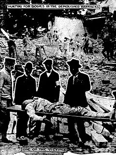
The 1920 Xalapa earthquake was the deadliest in Mexico's history prior to 1985—killing between 648 and 4,000 people. It occurred on January 3 at 22:25 local time, during a period of political unrest in the country. Mudflows and landslides triggered by the shock destroyed buildings in rural towns across Veracruz and Puebla. More than 400 people perished as a result. The earthquake was attributed to a shallow fault in the Trans-Mexican Volcanic Belt. It measured moment magnitude 6.3–6.4 and had a hypocenter depth of <15 km (9.3 mi). The Mexican government took immediate action in the aftermath—providing assistance and establishing communication services. Its aftershocks were studied by scientists and is widely regarded as the first scientific study of aftershocks following a major earthquake.
The 1979 Petatlán earthquake, also known as the IBERO earthquake occurred on March 14 at 05:07 local time in the Mexican state of Guerrero. The earthquake had a surface wave magnitude of Ms 7.6 or moment magnitude of Mw 7.4 and maximum Modified Mercalli intensity of VIII (Severe). The epicenter, onshore, was located 12 km south southeast of Vallecitos de Zaragoza.
The 1959 Coatzacoalcos earthquake occurred at 02:25 local time on August 26 near the Mexican state of Veracruz. The earthquake measured 6.4 Mw at a depth of 21 km (13 mi), and had a maximum Modified Mercalli intensity of VIII (Severe). It had an epicenter immediately off the coast of Coatzacoalcos. The shallow back-arc thrust faulting earthquake damaged the cities of Acayucan, Coatzacoalcos, Jáltipan and Minatitlán. A total of 25 people died, including 10 from Jáltipan while a further 200 were injured. The Middle America Trench, a subduction zone that borders the southwestern coast of Mexico and Central America, accounts for much of the seismicity in Mexico. The eastern side of the country near the Gulf of Mexico rarely experiences large earthquakes although they have been recorded around the Veracruz area, where seismicity is higher compared to other parts of the gulf. Seismicity in the gulf is attributed to back-arc compression due to subduction.
