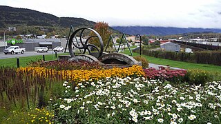
Terrace is a city in the Skeena region of northwestern British Columbia, Canada. This regional hub lies east of the confluence of the Kitsumkalum River into the Skeena River. On BC Highway 16, junctions branch northward for the Nisga'a Highway to the west and southward for the Stewart–Cassiar Highway to the east. The locality is by road about 204 km (127 mi) southwest of Smithers and 144 km (89 mi) east of Prince Rupert. Transportation links are the Northwest Regional Airport, a passenger train, and bus services.

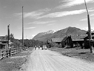
Hazelton is a village municipality in the Skeena region of west central British Columbia, Canada. The place is on the southeast side of the Skeena River immediately north of the Bulkley River mouth, where the confluence forms a peninsula. On BC Highway 62, the locality is by road about 75 kilometres (47 mi) northwest of Smithers and 144 kilometres (89 mi) northeast of Terrace. Hazelton is the original of the "Three Hazeltons", the other two being New Hazelton to the southeast and South Hazelton to the south.

Cambie Street is a street in Vancouver, British Columbia, Canada. It is named for Henry John Cambie, chief surveyor of the Canadian Pacific Railway's western division.

The Granville Street Bridge or Granville Bridge is an eight-lane fixed cantilever/truss bridge in Vancouver, British Columbia, Canada, carrying Granville Street between Downtown Vancouver southwest and the Fairview neighborhood. It spans False Creek and is 27.4 m (90 ft) above Granville Island. The bridge is part of Highway 99.
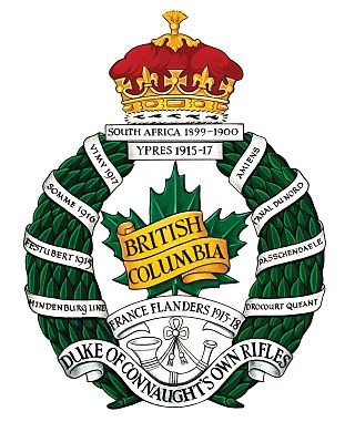
The British Columbia Regiment (Duke of Connaught's Own) is a Primary Reserve armoured reconnaissance (recce) regiment of the Canadian Army; the regiment is subordinate to 39 Canadian Brigade Group of the 3rd Canadian Division. Established in 1883, it is the oldest military unit in Vancouver, British Columbia, Canada. It parades at the Beatty Street Drill Hall at the corner of Dunsmuir and Beatty in Downtown Vancouver. The regiment has been variously designated as garrison artillery, rifles, infantry, and armoured, but has been reconnaissance since 1965. It has received 41 battle honours in its history, and has been a unit of the Royal Canadian Armoured Corps since 1942.

The Cambie Bridge is a six-lane, precast, box girder bridge spanning False Creek in Vancouver, British Columbia. The current bridge opened in 1985, but is the third bridge at the same location. Often referred to as the Cambie Street Bridge, it connects Cambie Street on the south shore of False Creek to both Nelson and Smithe Streets in the downtown peninsula. It is the easternmost of False Creek's fixed crossings; the Burrard and Granville bridges are a little more than a kilometre to the west, and the new Canada Line SkyTrain tunnel is built just west of the Cambie Bridge.

Eurana was a steam cargo ship built on speculation in 1915 by Union Iron Works of San Francisco. While under construction, the ship was acquired by Frank Duncan McPherson Strachan to operate in the Atlantic trade for his family's Strachan Shipping Company. The vessel made several trips between the Southeast of the United States and Europe before being sold to the Nafra Steamship Company in 1917. The freighter then entered the Mediterranean trade where she remained until September 1918 when she was requisitioned by the Emergency Fleet Corporation and transferred to the United States Navy to transport military supplies prior to the end of World War I, and as a troop transport after the war's end. In October 1919, the ship was returned to Nafra, which was then being reorganized to become the Green Star Steamship Company. In 1923, Eurana and twelve other ships passed to the Planet Steamship Company, newly formed to receive them from Green Star's bankruptcy. The ship remained principally engaged in the West Coast to East Coast trade for the next seven years. In 1930, together with several other vessels, Eurana was purchased by the Calmar Steamship Corporation, and renamed Alamar. The ship continued carrying various cargo between the East and West Coasts of the United States through 1941. On 27 May 1942, while en route from Hvalfjord to Murmansk carrying lend-lease war materiel to the Soviet Union during World War II as part of Arctic convoy PQ-16, she was fatally damaged by German aircraft bombs and was consequently scuttled by a British submarine to prevent her from becoming a menace to navigation.
Gitsegukla is an unincorporated community in the Skeena region of west central British Columbia, Canada. The place is on the southeast side of the Skeena River adjacent to the Kitseguecla River mouth. On BC Highway 16, the locality is by road about 94 kilometres (58 mi) northwest of Smithers and 113 kilometres (70 mi) northeast of Terrace.

The Beatty Street Drill Hall is a Canadian Forces armoury located at 620 Beatty Street in Vancouver, British Columbia. It is the home of The British Columbia Regiment, an armoured reconnaissance reserve regiment, the oldest military unit in Vancouver, and the most senior militia in the province.
New Hazelton is a district municipality on the south side of the Bulkley River in the Skeena region of west central British Columbia, Canada. On BC Highway 16, the locality is by road about 68 kilometres (42 mi) northwest of Smithers and 137 kilometres (85 mi) northeast of Terrace. New Hazelton is one of the "Three Hazeltons", the other two being the original "Old" Hazelton to the northwest and South Hazelton to the west.
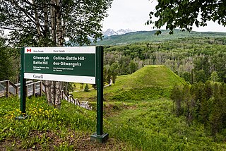
Kitwanga or Gitwangak is in the Skeena region of west central British Columbia. Among the Hazelton and Bulkley Mountain Ranges, the place is on the north shore of the Skeena River, east of the Kitwanga River confluence. On BC Highway 37, northeast of the junction with BC Highway 16, the locality is by road about 115 kilometres (71 mi) northwest of Smithers, 99 kilometres (62 mi) northeast of Terrace, and 212 kilometres (132 mi) southeast of Stewart.
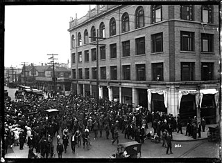
The 1918 Vancouver general strike was a general strike that took place in response to the death of Albert "Ginger" Goodwin on 2 August 1918. It was the first general strike in the history of British Columbia and a pivotal event in the Canadian Labour Revolt, which would unfold over the following years.

Kitselas Canyon is a canyon carved by the Skeena River in the Skeena region of west central British Columbia, Canada. Off BC Highway 16, the landmark is by road about 185 kilometres (115 mi) west of Smithers and 20 kilometres (12 mi) northeast of Terrace.
This is a timeline of the history of Vancouver.
The Bank of Vancouver was a Canadian chartered bank which operated 1910–1914 in British Columbia.
The SkyTrain rapid transit system in Greater Vancouver, Canada, was conceived as a legacy project of Expo 86 and was finished in time to showcase the fair's theme: "Transportation and Communication: World in Motion – World in Touch". Construction was funded by the provincial and federal governments. Vancouver had plans as early as the 1950s to build a monorail system, with modernist architect Wells Coates pencilled in to design it; that project was abandoned. The lack of a rapid transit system was said to be the cause of traffic problems in the 1970s, and the municipal government could not fund the construction of such a system. During the same period, Urban Transportation Development Corporation, then an Ontario crown corporation, was developing a new rapid transit technology known as an "Intermediate Capacity Transit System". In 1980, the need for rapid transit was great, and Ontario needed buyers for its new technology. "Advanced Rapid Transit" was selected to be built in Vancouver to showcase the Ontario project at Expo 86.

The steamship Kerry Range was a 5,800-ton general cargo freighter, armed with 4.7-inch (119 mm) guns, that had been built by the Northumberland Shipbuilding Company and launched on 27 November 1915. While serving as a Royal Navy armed transport she was damaged in a fire, with loss of life, in Baltimore, Maryland, in October 1917. Investigating officials, after the fire, were convinced the vessel was the target of arson, and that the arsonists were German agents—an enemy of the United Kingdom and the United States, during World War I. Several suspects were arrested. However, it was later determined that the fire on Pier 9, that triggered the fire on board Kerry Range, was due to an electrical malfunction that triggered oakum, a flammable product once used to pack seams on ships. Three crew members lost their lives. Firefighting officials towed the blazing vessel away from the pier, to help prevent it igniting nearby Pier 8, and scuttled her. It took over a day to completely put out the fires on the hulk. Some press reports at the time wrote she was a complete write-off. However, the damaged vessel was salvaged and sold to the Steam Navigation Company of Canada in 1918.
South Hazelton is an unincorporated community in the Skeena region of west central British Columbia, Canada. The place is on the east side of the Skeena River immediately south of the Bulkley River mouth. On BC Highway 16, the locality is by road about 73 kilometres (45 mi) northwest of Smithers and 132 kilometres (82 mi) northeast of Terrace. South Hazelton is one of the "Three Hazeltons", the other two being the original "Old" Hazelton to the north and New Hazelton to the east.
