1945 Pacific typhoon season | |
---|---|
Seasonal boundaries | |
First system formed | April 19, 1945 |
Last system dissipated | December 2, 1945 |
Strongest storm | |
Name | Ida |
• Maximum winds | 130 km/h (80 mph) (1-minute sustained) |
• Lowest pressure | 917 hPa (mbar) |
Seasonal statistics | |
Total storms | 26 |
Typhoons | 13 |
Super typhoons | 0 (unofficial) |
Total fatalities | >3,798 |
Total damage | Unknown |
Related articles | |
The 1945 Pacific typhoon season was the first official season to be included in the West Pacific typhoon database. It was also the first season to name storms. It has no official bounds; it ran year-round in 1945, but most tropical cyclones tend to form in the northwestern Pacific Ocean between June and December. These dates conventionally delimit the period of each year when most tropical cyclones form in the northwestern Pacific Ocean.
The scope of this article is limited to the Pacific Ocean, north of the equator and west of the international date line. Storms that form east of the date line and north of the equator are called hurricanes; see 1945 Pacific hurricane season. Predecessor agency to the Joint Typhoon Warning Center (JTWC), Fleet Weather Center/Typhoon Tracking Center was established on the island of Guam in June 1945, after multiple typhoons, including Typhoon Cobra in the previous season and Typhoon Connie in this season, had caused a significant loss of men and ships. [1] [2] It would not take major responsibility in the West Pacific basin until 1950 season. [1] Instead, storms in this season are identified and named by the United States Armed Services, and these names are taken from the list that USAS publicly adopted before this season had started earlier this year. [3] [4] Since this is the first season to be included in the West Pacific typhoon database, this would also be the first season where the names of Western Pacific tropical cyclones are preserved publicly.
Tropical storm (SSHWS) | |
Duration | April 19 – April 26 |
---|---|
Peak intensity | 95 km/h (60 mph) (1-min); 995 hPa (mbar) |
The first named storm of the season, Tropical Storm Ann formed on April 19 at relatively low latitude of 9.5°N. Ann generally tracked westward and later reached its peak intensity on April 21, before weakening to a tropical depression on April 23. The storm began to curve north the next day, and overall did not affect any landmasses and dissipated on April 26. [5]
Tropical storm (SSHWS) | |
Duration | May 13 – May 16 |
---|---|
Peak intensity | 100 km/h (65 mph) (1-min); 994 hPa (mbar) |
The second named storm of the season, Tropical Storm Betty formed on May 13, 1945, and began to move in a northeastern direction. It strengthened into a tropical storm only 18 hours later and continued on its path. However, the storm eventually moved further north, and into colder waters. Betty weakened into a tropical depression and dissipated on May 16, having not threatened land at all.
Category 1 typhoon (SSHWS) | |
Duration | June 1 – June 7 |
---|---|
Peak intensity | 130 km/h (80 mph) (1-min); 980 hPa (mbar) |
A small yet powerful typhoon, Connie was first spotted on June 1 by the Fleet Weather Center on Guam, moving northeast. Winds were reported to have been as high as 140 mph. But by June 7, it began to weaken. Its final fate is unknown.
The U.S. Navy's Third Fleet was hit by Connie, and reporting about the storm frequently refers to it as Typhoon Viper. The same fleet had previously been hit, with great loss of life, by Cobra the previous year. Connie being lesser, only one officer and five seamen were lost or killed because of Connie, and around 150 airplanes on its carriers were either lost or damaged.
Tropical storm (SSHWS) | |
Duration | June 18 – June 21 |
---|---|
Peak intensity | 85 km/h (50 mph) (1-min); 997 hPa (mbar) |
Tropical Storm Doris existed from June 18 to 21 and did not make landfall.
Tropical storm (SSHWS) | |
Duration | July 3 – July 8 |
---|---|
Peak intensity | 95 km/h (60 mph) (1-min); 992 hPa (mbar) |
Tropical Storm Nancy formed on July 3 to the east of Vietnam. It started to move in a northeast direction before shifting its course to the northwest until it eventually made landfall near Hong Kong as a tropical storm. It rapidly weakened over land and dissipated on June 8. The damage is unknown.
Category 1 typhoon (SSHWS) | |
Duration | July 14 – July 22 |
---|---|
Peak intensity | 120 km/h (75 mph) (1-min); 986 hPa (mbar) |
Tropical storm (SSHWS) | |
Duration | July 22 – July 23 |
---|---|
Peak intensity | 65 km/h (40 mph) (1-min); 998 hPa (mbar) |
Tropical storm (SSHWS) | |
Duration | July 27 – July 29 |
---|---|
Peak intensity | 75 km/h (45 mph) (1-min); 995 hPa (mbar) |
Category 1 typhoon (SSHWS) | |
Duration | July 30 – August 4 |
---|---|
Peak intensity | 150 km/h (90 mph) (1-min); 978 hPa (mbar) |
Category 1 typhoon (SSHWS) | |
Duration | August 5 – August 9 |
---|---|
Peak intensity | 150 km/h (90 mph) (1-min); 978 hPa (mbar) |
Tropical storm (SSHWS) | |
Duration | August 9 – August 13 |
---|---|
Peak intensity | 95 km/h (60 mph) (1-min); 992 hPa (mbar) |
Tropical storm (SSHWS) | |
Duration | August 15 – August 22 |
---|---|
Peak intensity | 110 km/h (70 mph) (1-min); 985 hPa (mbar) |
Category 1 typhoon (SSHWS) | |
Duration | August 22 – August 28 |
---|---|
Peak intensity | 130 km/h (80 mph) (1-min); 978 hPa (mbar) |
Category 1 typhoon (SSHWS) | |
Duration | August 23 – August 28 |
---|---|
Peak intensity | 150 km/h (90 mph) (1-min); 968 hPa (mbar) |
Category 1 typhoon (SSHWS) | |
Duration | August 23 – August 25 |
---|---|
Peak intensity | 130 km/h (80 mph) (1-min); 980 hPa (mbar) |
Category 3 typhoon (SSHWS) | |
Duration | August 29 – September 4 |
---|---|
Peak intensity | 195 km/h (120 mph) (1-min); 965 hPa (mbar) |
Typhoon Helen formed on August 29. It moved west-northwest and strengthened into a category 3 typhoon with 120 mph winds. It weakened slightly to a category two and struck Taiwan. It briefly was over waters before it hit Mainland China as a tropical storm. It rapidly weakened and dissipated on September 4.
Category 2 typhoon (SSHWS) | |
Duration | September 7 – September 15 |
---|---|
Peak intensity | 165 km/h (105 mph) (1-min); 968 hPa (mbar) |
This typhoon is especially remembered for the 6 aircraft containing liberated prisoners of war brought down by the typhoon between Okinawa and Manila. Over 120 servicemen lost their lives. At the time, it was the single greatest loss of life in an aviation disaster during peacetime. [6]
Category 1 typhoon (SSHWS) | |
Duration | September 10 – September 20 |
---|---|
Peak intensity | 130 km/h (80 mph) (1-min); 917 hPa (mbar) |
In Japan, Typhoon Ida is called Makurazaki Typhoon. It was the strongest typhoon to hit Kyushu on record, with a minimum sea-level pressure of 916.1 hPa (27.05 inHg) observed on the land and a maximum wind gust of 62.7 metres per second (140 mph), which was recorded at a weather station in Makurazaki. [7] More than 2,000 people were killed in the Hiroshima Prefecture after heavy rains brought by a weakening Ida caused severe landslides. [8]
Tropical storm (SSHWS) | |
Duration | September 20 – September 22 |
---|---|
Peak intensity | 95 km/h (60 mph) (1-min); 988 hPa (mbar) |
Tropical storm (SSHWS) | |
Duration | September 21 – September 24 |
---|---|
Peak intensity | 75 km/h (45 mph) (1-min); 998 hPa (mbar) |
Category 2 typhoon (SSHWS) | |
Duration | September 25 – October 2 |
---|---|
Peak intensity | 165 km/h (105 mph) (1-min); 963 hPa (mbar) |
Tropical storm (SSHWS) | |
Duration | September 28 – October 6 |
---|---|
Peak intensity | 110 km/h (70 mph) (1-min); 980 hPa (mbar) |
Category 1 typhoon (SSHWS) | |
Duration | October 2 – October 12 |
---|---|
Peak intensity | 150 km/h (90 mph) (1-min); 969 hPa (mbar) |
Louise was first seen developing on October 2, 1945, in the Caroline Islands. It unexpectedly veered north and slowed down, only to intensify as it passed over Okinawa on October 9 with 90 mph wind gusts and a minimum central pressure of 968.5 mbar. Shortly after, Louise began to weaken, and hit Japan as a strong tropical storm. The tropical cyclone became extratropical shortly after on October 12. In Okinawa, 36 people died, 47 people were reported missing, and 100 people were seriously injured.
In Buckner Bay, where the US military were occupying a temporary base, 30 ft (9.1 m) to 35 ft (11 m) waves were reported to have crashed ashore, tearing into Quonset huts and other buildings. At the time, Buckner Bay was being used as a port by the US military. Fifteen merchant ships were driven ashore, with a few wrecked. Three US Navy destroyers were grounded and declared beyond salvage. Over 200 other US military vessels, including six LSTs, a number of special purpose boats, patrol boats, and amphibious landing craft were grounded, severely damaged, or wrecked beyond repair. Eighty percent of the buildings in the bay were completely wiped out, while all 60 airplanes at the local airports were damaged. [9]
Tropical storm (SSHWS) | |
Duration | November 1 – November 4 |
---|---|
Peak intensity | 85 km/h (50 mph) (1-min); 996 hPa (mbar) |
A tropical storm was tracked on November 1 to the northwest of the Marianas. It moved to the west, before making landfall on Tayabas (now Quezon) in the Philippines. It was last noted on November 4 over Aurora. The damage is unknown.
Tropical storm (SSHWS) | |
Duration | November 14 – November 17 |
---|---|
Peak intensity | 75 km/h (45 mph) (1-min); 999 hPa (mbar) |
Category 1 typhoon (SSHWS) | |
Duration | November 22 – December 2 |
---|---|
Peak intensity | 150 km/h (90 mph) (1-min); 971 hPa (mbar) |
Typhoon Nora formed on November 22, 1945, and began to move towards the Philippines. It became a typhoon and a category 1 equivalent storm on the SSHWS scale. The slow-moving storm moved towards the Philippines, but it turned northeast at the last moment, moving over colder waters and dissipating.
|
|
|
The 1997 Pacific hurricane season was a very active hurricane season. With hundreds of deaths and hundreds of millions of dollars in damage, this was one of the deadliest and costliest Pacific hurricane seasons on record. This was due to the exceptionally strong 1997–98 El Niño event. The season officially started on May 15, in the eastern Pacific, and on June 1, in the central Pacific, and lasted until November 30. These dates conventionally delimit the period of each year when almost all tropical cyclones form in the northeastern Pacific Ocean.
The 1980 Pacific hurricane season officially started May 15, 1980, in the eastern Pacific and June 1, 1980, in the central Pacific, lasting until November 30, 1980. These dates conventionally delimit each year when most tropical cyclones form in the northeastern and central Pacific Ocean. This season was relatively uneventful; since no tropical cyclones made landfall, there were no reports of casualties or damage.
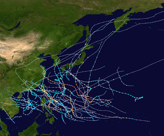
The 1999 Pacific typhoon season was the last Pacific typhoon season to use English names as storm names. It also featured the lowest number of typhoons on record with only five reaching this intensity. The season was a below-average season with only 20 named storms spawning. It had no official bounds; it ran year-round in 1999, but most tropical cyclones tend to form in the northwestern Pacific Ocean between May and November. These dates conventionally delimit the period of each year when most tropical cyclones form in the northwestern Pacific Ocean. The first named storm, Hilda, developed on January 6, while the last named storm, Gloria, dissipated on November 16.
The 1975 Pacific hurricane season officially started May 15, 1975, in the eastern Pacific, and June 1, 1975, in the central Pacific, and lasted until November 30, 1975. These dates conventionally delimit the period of each year when most tropical cyclones form in the northeast Pacific Ocean.
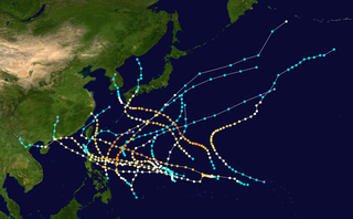
The 1991 Pacific typhoon season was a slightly above-average season with 29 tropical storms, 17 typhoons and five super typhoons forming. It was quite a catastrophic season – Typhoon Yunya impacted the Philippines in mid June while in the same time experiencing a volcanic eruption, Typhoon Mireille severely impacting Japan, which became known for being the costliest typhoon on record with US$10 billion worths of damages, and Tropical Storm Thelma on November which became one of the deadliest storms to strike the Philippines, killing at least over 5,000 people.
The 1990 Pacific typhoon season was another active season. It has no official bounds; it ran year-round in 1990, but most tropical cyclones tend to form in the northwestern Pacific Ocean between May and November. These dates conventionally delimit the period of each year when most tropical cyclones form in the northwestern Pacific Ocean.
The 1979 Pacific typhoon season featured the largest and most intense tropical cyclone recorded globally, Typhoon Tip. The season also experienced slightly below-average tropical cyclone activity. The season had no official bounds; it ran year-round in 1979, but most tropical cyclones tend to form in the northwestern Pacific Ocean between June and December. These dates conventionally delimit the period of each year when most tropical cyclones form in the northwestern Pacific Ocean.
The 1970 Pacific typhoon season has no official bounds; it ran year-round in 1970, but most tropical cyclones tend to form in the northwestern Pacific Ocean between June and December. These dates conventionally delimit the period of each year when most tropical cyclones form in the northwestern Pacific Ocean.
The 1974 Pacific typhoon season was the first season on record to not feature a Category 5 equivalent super typhoon; a feat later repeated by the 1977 and 2017 seasons. Even so, the season was overly active, with 32 tropical storms and 16 typhoons being developed this year. It has no official bounds; it ran year-round in 1974, but most tropical cyclones tend to form in the northwestern Pacific Ocean between June and December. These dates conventionally delimit the period of each year when most tropical cyclones form in the northwestern Pacific Ocean.
The 1972 Pacific typhoon season was an above average season, producing 31 tropical storms, 24 typhoons and 2 intense typhoons. It has no official bounds; it ran year-round in 1972, but most tropical cyclones tend to form in the northwestern Pacific Ocean between June and December. These dates conventionally delimit the period of each year when most tropical cyclones form in the northwestern Pacific Ocean.
The 1961 Pacific typhoon season had no official bounds; it ran year-round in 1961, but most tropical cyclones tend to form in the northwestern Pacific Ocean between June and December. These dates conventionally delimit the period of each year when most tropical cyclones form in the northwestern Pacific Ocean.
The 1960 Pacific typhoon season had no official bounds; it ran year-round in 1960, but most tropical cyclones tend to form in the northwestern Pacific Ocean between June and December. These dates conventionally delimit the period of each year when most tropical cyclones form in the northwestern Pacific Ocean.
The 1957 Pacific typhoon season has no official bounds; it ran year-round in 1957, but most tropical cyclones tend to form in the northwestern Pacific Ocean between June and December. These dates conventionally delimit the period of each year when most tropical cyclones form in the northwestern Pacific Ocean.
The 1956 Pacific typhoon season has no official bounds; it ran year-round in 1956, but most tropical cyclones tend to form in the northwestern Pacific Ocean between June and December. These dates conventionally delimit the period of each year when most tropical cyclones form in the northwestern Pacific Ocean.
The 1950 Pacific typhoon season has no official bounds; it ran year-round in 1950, but most tropical cyclones tend to form in the northwestern Pacific Ocean between June and December. These dates conventionally delimit the period of each year when most tropical cyclones form in the northwestern Pacific Ocean.
The 1947 Pacific typhoon season has no official bounds; it ran year-round in 1947, but most tropical cyclones tend to form in the northwestern Pacific Ocean between June and December. These dates conventionally delimit the period of each year when most tropical cyclones form in the northwestern Pacific Ocean.
The 1946 Pacific typhoon season has no official bounds; it ran year-round in 1946, but most tropical cyclones tend to form in the northwestern Pacific Ocean between June and December. These dates conventionally delimit the period of each year when most tropical cyclones form in the northwestern Pacific Ocean.
The 1966 Pacific hurricane season started on May 15, 1966, and ended November 30, 1966. The season was of little note. Hurricane Blanca traveled 4,300 miles, setting a new record. During September and October of the year, Hurricane Helga and Tropical Storms Kirsten, Lorraine, and Maggie hitting Mexico. Kirsten caused 8 deaths and US$5.6 million in damages in Mexico.
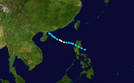
Typhoon Oliwa was one of a record eleven super typhoons in the 1997 Pacific typhoon season. Oliwa formed in the central Pacific Ocean on September 2 to the southwest of Hawaii, but it became a typhoon in the western Pacific. Oliwa explosively intensified on September 8, increasing its winds from 85 mph to 160 mph in a 24‑hour period. Afterward, it slowly weakened, and after passing east of Okinawa, Oliwa turned northeast and struck Japan with winds of 85 mph (137 km/h). There, it affected 30,000 people and killed 12; thousands of houses were flooded, and some were destroyed. Offshore South Korea, the winds and waves wrecked 28 boats, while one boat went missing with a crew of 10 people. Oliwa dissipated on September 19 in northern Pacific Ocean near the International Date Line.