The Five Principles of Peaceful Coexistence are principles first mentioned in the Sino-Indian Agreement, 1954. They are mutual respect for territorial integrity and sovereignty, mutual non-aggression, mutual non-interference in internal affairs, equality and co-operation for mutual benefit and peaceful co-existence. Also known as Panchsheel, these principles were subsequently adopted in a number of resolutions and statements, including the preamble to the Constitution of the People's Republic of China.

Nathu La (Tibetan: རྣ་ཐོས་ལ་, Wylie: Rna thos la, THL: Na tö la, Chinese: 乃堆拉山口) is a mountain pass in the Dongkya Range of the Himalayas between China's Yadong County in Tibet, and the Indian states of Sikkim and West Bengal in Bengal, South Asia. The pass, at 4,310 m (14,140 ft), connects the towns of Kalimpong and Gangtok to the villages and towns of the lower Chumbi Valley.
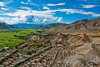
Gyantse, officially Gyangzê Town, is a town located in Gyantse County, Shigatse Prefecture, Tibet Autonomous Region, China. It was historically considered the third largest and most prominent town in the Tibet region, but there are now at least ten larger Tibetan cities.
Gartok, is made of twin encampment settlements of Gar Günsa and Gar Yarsa in the Gar County in the Ngari Prefecture of Tibet. Gar Gunsa served as the winter encampment and Gar Yarsa as the summer encampment. But in British nomenclature, the name Gartok was applied only to Gar Yarsa and the practice continues till date.

Rudok, also spelt Rutok and Rutog, more properly Rudok Dzong, is a town that served as the historical capital of the Rudok area in Western Tibet on the frontier with Ladakh. In the 1911 Encyclopædia Britannica, it is described as being "picturesquely situated" on the side of a hill standing isolated in the plain near the east end of Lake Pangong.

China National Highway 219 is a highway which runs along the entire western and southern border of the People's Republic of China, from Kom-Kanas Mongolian ethnic township in Xinjiang to Dongxing in Guangxi. At over 10,000 kilometres (6,214 mi) long, it is part of the China National Highway Network Planning (2013–2030), and once completed it will be the longest National Highway.

Shipki La is a mountain pass and border post with a dozen buildings of significant size on the India-China border. The river Sutlej, which is called Langqên Zangbo in Tibet, enters India near this pass. A spur road on the Indian side rises to an altitude of 4,720 metres (15,490 ft) four km southwest of Shipki La.

The British expedition to Tibet, also known as the Younghusband expedition, began in December 1903 and lasted until September 1904. The expedition was effectively a temporary invasion by British Indian Armed Forces under the auspices of the Tibet Frontier Commission, whose purported mission was to establish diplomatic relations and resolve the dispute over the border between Tibet and Sikkim. In the nineteenth century, the British had conquered Burma and Sikkim, with the whole southern flank of Tibet coming under the control of the British Indian Empire. Tibet ruled by the Dalai Lama under the Ganden Phodrang government was a Himalayan state under the suzerainty of the Chinese Qing dynasty until the 1911 Revolution, after which a period of de facto Tibetan independence (1912-1951) followed.

Yatung or Yadong, also known as Shasima , is the principal town in the Chumbi Valley or Yadong County in the Tibet Autonomous Region of China. It is also its administrative headquarters.

This is a survey of the postage stamps and postal history of Tibet.
The Kongka Pass or Kongka La is a low mountain pass on the Line of Actual Control between India and China in eastern Ladakh. It lies on a spur of the Karakoram range that intrudes into the Chang Chenmo Valley adjacent to the disputed Aksai Chin region. China claimed the location as its border in a 1956 map, and attacked an Indian patrol party in 1959 killing ten policemen and apprehending ten others. Known as the Kongka Pass incident, the event was a milestone in the escalation of the border dispute between the two countries.
The Dogra–Tibetan War or Sino-Sikh War was fought from May 1841 to August 1842, between the forces of the Dogra nobleman Gulab Singh of Jammu, under the suzerainty of the Sikh Empire, and those of Tibet. Gulab Singh's commander was the able general Zorawar Singh Kahluria, who, after the conquest of Ladakh, attempted to extend its boundaries in order to control the trade routes into Ladakh. Zorawar Singh's campaign, suffering from the effects of inclement weather, suffered a defeat at Minsar and Singh was killed. The Tibetans then advanced on Ladakh. Gulab Singh sent reinforcements under the command of his nephew Jawahir Singh. A subsequent battle near Leh in 1842 led to a Tibetan defeat. The Treaty of Chushul was signed in 1842 maintaining the status quo ante bellum.

The Macartney–MacDonald Line is a proposed boundary in the disputed area of Aksai Chin. It was proposed by British Indian Government to China in 1899 via its envoy to China, Sir Claude MacDonald. The Chinese Government never gave any response to the proposal. The Indian Government believed that, subsequently British India reverted to its traditional boundary, the Johnson–Ardagh Line. Independent scholars have not confirmed the claim.

The Convention of Lhasa, officially the Convention Between Great Britain and Thibet, was a treaty signed in 1904 between Tibet and Great Britain, in Lhasa, the capital of Tibet. It was signed following the British expedition to Tibet of 1903–1904, a military expedition led by Colonel Francis Younghusband, and was followed by the Anglo-Chinese Convention of 1906.
Lakshman Singh Jangpangi (1905-1976) was an Indian civil servant and a former Indian Trade Agent at Gartok and Yatung regions. He was born on 24 July 1905 at Burfu, in the Johar Valley of the Indian state of Uttarakhand to Rai Saheb Sohan Singh, a rich official of the British administration. He did his schooling in Almora and completed BA Final at Allahabad University.
Demchok , previously called New Demchok, and called Parigas by the Chinese, is a village and military encampment in the Indian-administered Demchok sector that is disputed between India and China. It is administered as part of the Nyoma tehsil in the Leh district of Ladakh by India, and claimed by China as part of the Tibet Autonomous Region.
The Demchok sector is a disputed area named after the villages of Demchok in Ladakh and Demchok in Tibet, situated near the confluence of the Charding Nullah and Indus River. It is a part of the greater Sino-Indian border dispute between China and India. Both China and India claim the disputed region, with a Line of Actual Control between the two nations situated along the Charding Nullah.

Tibet–India relations are said to have begun during the spread of Buddhism to Tibet from India during the 7th and 8th centuries AD. In 1959, the Dalai Lama fled to India after the failed 1959 Tibetan uprising. Since then, Tibetans-in-exile have been given asylum in India, with the Indian government accommodating them into 45 residential settlements across 10 states in the country. From around 150,000 Tibetan refugees in 2011, the number fell to 85,000 in 2018, according to government data. Many Tibetans are now leaving India to go back to Tibet and other countries such as United States or Germany. The Government of India, soon after India's independence in 1947, treated Tibet as a de facto independent country. However, more recently India's policy on Tibet has been mindful of Chinese sensibilities, and has recognized Tibet as a part of China.
Barahoti, also called Wu-Je or Wure, is a 1.5 square miles (3.9 km2) sloping plain located in the Indian state of Uttarakhand, Chamoli district. It is disputed by China, which also disputes a 750 square kilometres (290 sq mi) area surrounding it. The entire disputed area also goes by the name "Barahoti", or sometimes "Barahoti–Sangchamalla–Lapthal disputed area". The entire area is on the Ganges side of the Sutlej–Ganges water divide, which is also the current Line of Actual Control between India and China.
Dumchele or Dhumtsele (Chinese: 都木契列; pinyin: Dōu mù qì liè, Tibetan: སྡུམ་མཚེས་ལེ་, Wylie: sdum mtshes le, THL: dum tsé lé) is a village and a grazing area near the Line of Actual Control between Ladakh and Tibet, administered by China since October 1962 but claimed by India. The locale is in the disputed Demchok sector, about 50 kilometers northwest from Demchok and 50 kilometers southeast of Chushul. It lies on a historic trade route between Ladakh and Rutog, with an erstwhile border pass at Chang La or Shingong La to the southeast of Dumchele.