Atarfe is a Spanish city in the north central part of the Vega of Granada in the province of Granada, Andalusia. It borders the municipalities of Moclín, Colomera, Albolote, Maracena, Granada, Santa Fe, and Pinos Puente. By this village run the Rivers Cubillas and Colomera. Its districts include Caparacena, Sierra Elvira, Hurpe and Cubillas.
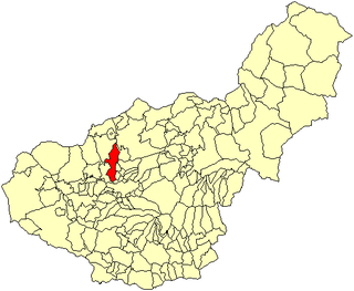
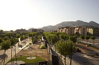
Albolote is a city located in the province of Granada, Spain. It is one of the thirty-four entities which together form Granada's Metropolitan Area. It is formed by several populations: El Aire, El Chaparral, and Parque del Cubillas y Pretel. There are also several residential areas throughout the legal borders of the municipality. Inside those limits you can also find Granada's Penitential Center. According to Spain's Instituto Nacional de Estadística, the city had a total population of 15,563 in 2005.

Maracena is a municipality located in the province of Granada, Spain. According to the 2005 census (INE), the city has a population of 18819 inhabitants. It is located in the central part of the Vega de Granada, being one of the fifty-two entities that make up the metropolitan area of Granada.It borders the municipalities of Peligros, Pulianas, Granada, Atarfe and Albolote. Other nearby towns are Pulianillas and Monteluz.

The Vega de Granada is a comarca in the province of Granada, southeastern Spain. According to the 2007 census (INE), the comarca has a population of 500,121 inhabitants, which is over half the overall population of the province.
The 1985 Rapel Lake earthquake occurred on 8 April at with a moment magnitude of 7.2 and a maximum perceived intensity of VI (Strong). The shock was centered 75 kilometres (47 mi) southwest of Santiago, Chile, with a focal depth of 37.8 km (23 mi).

The 2011 Lorca earthquake was a moderate 5.1 earthquake that occurred 6:47 p.m. CEST on 11 May 2011, near the town of Lorca, causing significant localized damage in the Region of Murcia, Spain, and panic among locals, and displacing many from their homes. The quake was preceded by a magnitude 4.4 foreshock at 17:05, that inflicted substantial damage to many older structures in the area, including the historical Espolón Tower of Lorca Castle, the Hermitage of San Clemente and the Convent of Virgen de Las Huertas. Three people were killed by a falling cornice. A total of nine deaths have been confirmed, while dozens are reported injured. The earthquake was the worst to hit the region since a 5.0 Mw tremor struck west of Albolote, Granada in 1956.

In May 2012, two major earthquakes struck Northern Italy, causing 27 deaths and widespread damage. The events are known in Italy as the 2012 Emilia earthquakes, because they mainly affected the Emilia region.
The 2012 Costa Rica earthquake occurred at 08:42 local time on September 5. The epicenter of the 7.6 Mw earthquake was in the Nicoya Peninsula, 11 kilometers east-southeast of Nicoya. A tsunami warning was issued shortly afterwards, but later cancelled. Two people are known to have died, one from a heart attack and another, a construction worker, crushed by a collapsing wall. It was the second strongest earthquake recorded in Costa Rica's history, following the 1991 Limon earthquake.

The Granada Metro is a single light rail line in the city of Granada, Spain and its metropolitan area. It crosses Granada and covers the towns of Albolote, Maracena and Armilla, with underground sections in central Granada and overground sections elsewhere. The line opened on 21 September 2017, and serves 26 stations, of which 3 stations in central Granada are underground.
The 1844 Salta earthquake took place in the Province of Salta, in the Republic of Argentina, on 18 October at 23:00 UTC. It had an estimated magnitude of 6.5 . The earthquake had an estimated hypocentral depth of 30 km.
The 2000 Nicaragua earthquake occurred at 19:30 UTC on July 6. It had a magnitude of 5.4 on the moment magnitude scale and caused 7 deaths and 42 injuries. 357 houses were destroyed and 1,130 others were damaged in the earthquake.
The February 2001 El Salvador earthquake occurred with a moment magnitude of 6.6 on 13 February at 14:22:05 UTC. The epicentre was 15 miles (30 km) E of San Salvador, El Salvador, at a depth of 10 km. At least 315 people were killed, 3,399 were injured, and extensive damage affected the area. Another 16,752 homes were damaged and 44,759 destroyed. The most severe damage occurred in the San Juan Tepezontes-San Vicente-Cojutepeque area, though it was felt throughout the country and in neighboring Guatemala and Honduras. Landslides occurred in many areas of El Salvador.
The 1838 San Andreas earthquake is believed to be a rupture along the northern part of the San Andreas Fault in June 1838. It affected approximately 100 km of the fault, from the San Francisco Peninsula to the Santa Cruz Mountains. It was a strong earthquake, with an estimated moment magnitude of 6.8 to 7.2, making it one of the largest known earthquakes in California. The region was lightly populated at the time, although structural damage was reported in San Francisco, Oakland, and Monterey. It is unknown whether there were fatalities. Based on geological sampling, the fault created approximately 1.5 meters of slip.

The 1884 Andalusian earthquake occurred on 25 December 1884 at 9:08 p.m in the south of Spain, and had an estimated magnitude of 6.7 . It shook a poor region where many of the houses were built without foundations, with lime or mud mortar, and with weak joints. More than 10,000 buildings were badly damaged, of which 4,399 were completely destroyed. There were over 1,200 deaths and 1,500 serious injuries, however, many people were in the streets celebrating Christmas hence casualties were not higher. The heavy snow that followed the earthquake caused further suffering and deaths. Help was slow to arrive at first, but as the news spread food and blankets arrived, then tents, and then donations from around the world helped with reconstruction.
Starting on December 28, 2019, and progressing into 2020, the southwestern part of the island of Puerto Rico was struck by an earthquake swarm, including 11 that were of magnitude 5 or greater. The largest and most damaging of this sequence was a magnitude 6.4 , which occurred on January 7 at 04:24 AST (08:24 UTC), with a maximum felt intensity of VIII (Severe) on the Modified Mercalli intensity scale. At least one person was killed, and several others were injured.
The 1921 Sevier Valley earthquake was a series of three earthquakes. The primary quake was a magnitude 6.3 earthquake that occurred on Thursday, 29 September 1921 at approximately 7:12 AM MT in Elsinore, Utah, United States. The first aftershock occurred in the evening on the same day, and a second aftershock occurred two days later on 1 October. No people were killed in the quake or in the subsequent aftershocks.
The 1900 Venezuelan earthquake, occurred on October 28 at between 4:30 and 4:45 am local time. This earthquake had an epicenter off Miranda State or near the Venezuelan capital Caracas, in the Cariaco Basin. It had an estimated moment magnitude of 7.6–7.7 and a surface-wave magnitude of 7.7–8.4. It had a maximum Mercalli intensity assigned VIII–X, causing landslides and liquefaction events. Many buildings were severely damaged or collapsed during the earthquake. It is thought to be the last great earthquake of the 19th century and the largest instrumentally recorded in the republic, having been felt throughout.

A major earthquake struck northern Peru on November 28, 2021, 5:52 a.m. local time with a magnitude of 7.5 on the moment magnitude scale between the Amazonas and Loreto departments of Peru. A maximum Modified Mercalli intensity (MMI) of VII was reported in the town of Santa Maria de Nieva according to the Geological Institute of Peru.
The 1804 Almería earthquake was a highly destructive seismic event in the Province of Almería, southern Spain. It occurred on 25 August at 8:25 pm local time. The mainshock had a maximum intensity assigned VIII–IX on the European macroseismic scale (EMS), and an estimated moment magnitude of 6.2–6.4 Mw . At least 400 people were reported killed.

