| |||||
| Decades: | |||||
|---|---|---|---|---|---|
| See also: | |||||

Events in the year 1961 in Nigeria .
| |||||
| Decades: | |||||
|---|---|---|---|---|---|
| See also: | |||||
Events in the year 1961 in Nigeria .

Bakassi is a peninsula on the Gulf of Guinea. It lies between the Cross River estuary, near the city of Calabar in the west of the Bight of Biafra, and the Rio del Ray estuary on the east. It is governed by Cameroon, following the transfer of sovereignty from neighbouring Nigeria as a result of a judgment by the International Court of Justice. On 22 November 2007, the Nigerian Senate rejected the transfer, since the Greentree Agreement ceding the area to Cameroon was contrary to Section 12(1) of the 1999 Constitution. Regardless, the territory was completely ceded to Cameroon on 14 August 2008, exactly two years after the first part of it was transferred.

Cameroon, officially the Republic of Cameroon, is a country in west-central Africa. It is bordered by Nigeria to the west and north; Chad to the northeast; the Central African Republic to the east; and Equatorial Guinea, Gabon and the Republic of the Congo to the south. Its coastline lies on the Bight of Biafra, part of the Gulf of Guinea and the Atlantic Ocean. The country is sometimes identified as West African and other times as Central African, due to its strategic position at the crossroads between West and Central Africa. Its nearly 25 million people speak 250 native languages.
At the crossroads of West Africa and Central Africa, the territory of what is now Cameroon has seen human habitation since some time in the Middle Paleolithic, likely no later than 130,000 years ago. The earliest discovered archaeological evidence of humans dates from around 30,000 years ago at Shum Laka. The Bamenda highlands in western Cameroon near the border with Nigeria are the most likely origin for the Bantu peoples, whose language and culture came to dominate most of central and southern Africa between 1000 BCE and 1000 CE.

At 475,440 km2 (183,570 sq mi), Cameroon is the world's 53rd largest country. It is slightly larger than the nation of Sweden and the US state of California. It is comparable in size to Papua New Guinea. Cameroon's landmass is 472,710 km2 (182,510 sq mi), with 2,730 km2 (1,050 sq mi) of water.

Nigeria is a country in West Africa. Nigeria shares land borders with the Republic of Benin in the west, Chad and Cameroon in the east, and Niger in the north. Its coast lies on the Gulf of Guinea in the south and it borders Lake Chad to the northeast. Noted geographical features in Nigeria include the Adamawa Plateau, Mambilla Plateau, Jos Plateau, Obudu Plateau, the Niger River, Benue River, and Niger Delta.

British Cameroon or British Cameroons was a British mandate territory in British West Africa, formed of Northern Cameroons and Southern Cameroons. Today, Northern Cameroons forms parts of the Borno, Adamawa, and Taraba states of Nigeria, and Southern Cameroons is a part of Cameroon.

Ambazonia, officially the Federal Republic of Ambazonia, also referred to as Amba Land, is an unrecognised breakaway state in West Africa constituting the Northwest Region and Southwest Region of Cameroon, part of the British mandate territory historically known as the Southern Cameroons. No country has formally recognized Ambazonia's independence, and it is currently the site of an armed conflict between Ambazonian separatists and the Cameroonian military known as the Anglophone Crisis. Ambazonia is located in the west of Cameroon and southeast of Nigeria on the Gulf of Guinea.

Adamawa State is a state in the North-East geopolitical zone of Nigeria, bordered by Borno to the northwest, Gombe to the west, and Taraba to the southwest while its eastern border forms part of the national border with Cameroon. It takes its name from the historic emirate of Adamawa, with the emirate's old capital of Yola serving as the capital city of Adamawa State. The state—one of the most heterogeneous in Nigeria with over 100 indigenous ethnic groups—was formed in 1991 when the former Gongola State was broken up into Adamawa and Taraba states.

Borno State is a state in the North-East geopolitical zone of Nigeria, bordered by Yobe to the west, Gombe to the southwest, and Adamawa to the south while its eastern border forms part of the national border with Cameroon, its northern border forms part of the national border with Niger, and its northeastern border forms all of the national border with Chad, being the only Nigerian state to border three foreign countries. It takes its name from the historic emirate of Borno, with the emirate's old capital of Maiduguri serving as the capital city of Borno State. The state was formed in 1976 when the former North-Eastern State was broken up. It originally included the area that is now Yobe State, which became a distinct state in 1991.
Southern Cameroons was the southern part of the British mandate territory of British Cameroons in West Africa. Since 1961, it has been part of the Republic of Cameroon, where it makes up the Northwest Region and Southwest Region. Since 1994, pressure groups in the territory claim there was no legal Document in accordance to UNGA RES 1608(XV) paragraph 5, and are seeking to restore statehood and independence from the Republic of Cameroon. They renamed British Southern Cameroons as Ambazonia.
Boko Haram, officially known as Jamā'at Ahl as-Sunnah lid-Da'wah wa'l-Jihād, is a terrorist organization based in northeastern Nigeria, which is also active in Chad, Niger, and northern Cameroon. In 2016, the group split, resulting in the emergence of a hostile faction known as the Islamic State's West Africa Province.
Dikwa is a town located in Borno State, Nigeria.
Kurmi is a Local Government Area in Taraba State, Nigeria. As a local government area it is administered by a Local Government Council consisting of a chairman, and elected councillors. The LGA is further divided into wards. Its headquarters are in the town of Ba'Issa.

The Boko Haram insurgency began in July 2009, when the militant Islamist and jihadist rebel group Boko Haram started an armed rebellion against the government of Nigeria. The conflict takes place within the context of long-standing issues of religious violence between Nigeria's Muslim and Christian communities, and the insurgents' ultimate aim is to establish an Islamic state in the region.
This is a survey of the postage stamps and postal history of Nigeria.

This article is a survey of the postage stamps and postal history of the British Cameroons. It falls into two essential parts: the occupation of German Kamerun by Anglo-French forces in 1915, when German Colonial stamps were issued with an overprint and surcharge; and the situation following a 1961 plebiscite, after which the former British Cameroons, today known as Ambazonia, was divided between Cameroon and Nigeria.
A United Nations referendum was held in British Cameroons on 11 February 1961 to determine whether the territory should join neighbouring Cameroon or Nigeria. The option of independence was not on the ballot, having been opposed by Andrew Cohen, the UK representative to the UN Trusteeship Council, as well as African and anti-colonial delegations, notably by E. M. L. Endeley, who favoured integration with Nigeria, and John Ngu Foncha, who favoured (eventual) reunification with Francophone Cameroon.

French Cameroon or French Cameroons was a League of Nations Mandate territory in Central Africa. It now forms part of the independent country of Cameroon.

Anthene rubricinctus, the indigo ciliate blue, is a butterfly in the family Lycaenidae. It is found in Guinea, Sierra Leone, Liberia, Ivory Coast, Ghana, Togo, Nigeria, Cameroon, the Republic of the Congo, Gabon, Angola, the Democratic Republic of the Congo, Uganda, Kenya, Tanzania, Malawi and Zambia. The habitat consists of forest, especially stream banks.
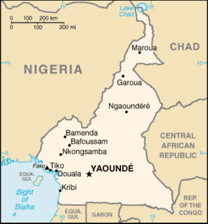
The Cameroon–Nigeria border is 1,975 km in length and runs from the tripoint with Chad in the north to the Atlantic Ocean in the south.
| | This year in Africa article is a stub. You can help Wikipedia by expanding it. Contents |