The 2007 Kuril Islands earthquake occurred east of the Kuril Islands on 13 January at . The shock had a moment magnitude of 8.1 and a maximum Mercalli intensity of VI (Strong). A non-destructive tsunami was generated, with maximum wave amplitudes of 0.32 meters. The earthquake is considered a doublet of the 8.3 magnitude 2006 Kuril Islands earthquake which occurred two months prior on 15 November 2006 approximately 95 km to the southeast.
The 2003 Colima earthquake occurred on 21 January with a moment magnitude of 7.6 and a maximum Mercalli intensity of VIII (Severe). The epicenter was located on the Pacific coast in the Mexican state of Colima. The earthquake was felt as far away as Mexico City and in southern parts of the United States.
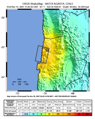
The 2007 Tocopilla earthquake occurred on November 14 at . Its epicenter was located between Quillagua and Tocopilla, affecting the Tarapacá and the Antofagasta regions in northern Chile. The earthquake had a moment magnitude of 7.7 and lasted about 3 minutes and 35 seconds. Seventeen aftershocks of magnitude greater than 5.3, including one of magnitude 7.1 and two others of magnitude 6.3 or higher, were recorded. The Pacific Tsunami Warning Center issued a tsunami warning, stating a tsunami had been generated; after one hour, this warning was cancelled. The earthquake was felt from Santiago, 1,245 km south from the epicenter, to La Paz, about 700 km north-northeast.
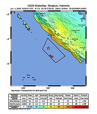
At 23:28 local time on June 4, 2000, southern Sumatra, Indonesia was struck by an earthquake of moment magnitude 7.9 with a maximum Mercalli intensity of VI (Strong). The event occurred off the coast near Enggano Island. There were more than 100 fatalities and up to 2,585 injuries. Over 730 aftershocks shook the area afterwards, one just eleven minutes after the mainshock.

The 1915 Pleasant Valley earthquake occurred at in north-central Nevada. With a moment magnitude of 6.8, a surface wave magnitude of 7.7, and a maximum Mercalli intensity of X (Extreme), it was the strongest earthquake ever recorded in the state.

The 1995 Neftegorsk earthquake occurred on 28 May at on northern Sakhalin Island in the Russian Far East. It was the most destructive earthquake known within the current state of Russia, with a magnitude of 7.1 and maximum Mercalli intensity of IX (Violent) that devastated the oil town of Neftegorsk, where 1,989 of its 3,977 citizens were killed, and another 750 injured.
The 2007 Martinique earthquake took place on November 29 2007 at in the Windward Islands region, underneath the Martinique Passage. It was a magnitude 7.4 earthquake that occurred 18 km (11 mi) west northwest from Basse-Pointe, Martinique.
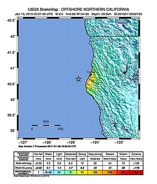
The 2010 Eureka earthquake occurred on January 9 at 4:27:38 pm PST offshore of Humboldt County, California, United States. The magnitude was measured 6.5 on the scale, and its epicenter was located offshore in the Pacific Ocean 33 miles (53 km) west of the nearest major city, Eureka. Additionally, there was a separate earthquake further offshore of Eureka on February 4 with a slightly lower magnitude of 5.9. It was also the most significant earthquake in the Eureka area in terms of magnitude since the 1992 Cape Mendocino earthquakes. It was felt from Santa Cruz County, California in the south, to Eugene, Oregon in the north and to the east as far as Reno, Nevada.
The 1995 Colima–Jalisco earthquake occurred on October 9 at 15:35 UTC with a moment magnitude of 8.0 and a maximum Mercalli intensity of VIII (Severe). The shock occurred off the coast of Jalisco, Mexico, where a tsunami was triggered that affected a 200 km (120 mi) stretch of the coast. The earthquake could be felt in Mexico City and in high-rise buildings in Dallas and Houston. In Mexico, the Cihuatlan-Manzanillo was the most severely affected area. At least 49 people died and 100 were injured.
The 1997 Harnai earthquake occurred on February 27 at 21:08 UTC near Harnai, Pakistan, and felt throughout much of central Balochistan, with a magnitude estimated at 7.0 on the scale. A 2016 study determined that this was a doublet earthquake, the Mw 6.8 shock that hit 19 seconds later being a continuation of the initial main shock. The largest aftershock was an 6.4 shock that hit 22 minutes after the main shock. The earthquake was caused by the collision between the Indian plate and the Eurasian plate.
The 1996 Chimbote earthquake occurred on February 21 at about 130 km off the coast of northern Peru, near the Peru–Chile Trench. The earthquake had a moment magnitude of 7.5 and occurred at 25.0 km (15.5 mi) depth.

An earthquake occurred on June 3, 1994, at 01:17:37 local time off the coast of Indonesia. The epicenter was off the eastern part of the southern Java coast, near the east end of the Java Trench.
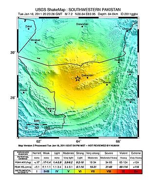
The 2011 Dalbandin earthquake occurred on with a moment magnitude of 7.2 and a maximum Mercalli intensity of VII. The shock occurred in a sparsely populated area of Balochistan, caused moderate damage, three deaths, and some injuries.
The 1953 Suva earthquake occurred on 14 September at 00:26 UTC near Suva, Fiji, just off the southeast shore of Viti Levu. This earthquake had an estimated magnitude of 6.8 and 6.4. The earthquake triggered a coral reef platform collapse and a submarine landslide that caused a tsunami. Eight people were reported killed.
The 1968 Hyūga-nada earthquake occurred on April 1 at . The earthquake had a magnitude of 7.5, and the epicenter was located in Hyūga-nada Sea, off the islands of Kyushu and Shikoku, Japan. The magnitude of this earthquake was also given as 7.5. A tsunami was observed. One person was killed, and 22 people were reported injured. The intensity reached shindo 5 in Miyazaki and Kōchi.
The 1941 Andaman Islands earthquake struck the Andaman Islands on June 26 with a magnitude of 7.7 to 8.1. Details of this event are poorly known as much of Southeast Asia was in the turmoil of World War II. The quake caused severe damage in the Andaman Islands. The tsunami it triggered was reported along the Andaman and Nicobar Islands, India and British Ceylon. There may have been damage and deaths in Bangladesh, Myanmar, and Thailand due to the tsunami.
The 1932 Eureka earthquake occurred on June 6 at along the northern coastal area of California in the United States. With a moment magnitude of 6.4 and a maximum Mercalli intensity of VIII (Severe), this earthquake left one person dead from a falling chimney and several injured. The shock was the largest in the area since 1923 and was felt in southern Oregon and northern California.
The 1963 Marj earthquake occurred on February 21 in northern Libya. The earthquake occurred at with a moment magnitude of 5.6 and a maximum Mercalli intensity of VIII (Severe). Financial losses totaled US$5 million, with 290–375 deaths, 375–500 injuries, and 12,000 people being rendered homeless.
The 1976 Longling earthquake in Yunnan Province, People's Republic of China, was a doublet earthquake, with two main shocks striking just east of Longling at 12:23:20 and 14:00:22 UTC. The magnitudes were estimated at 6.7 and 6.6, respectively, on the (GCMT) scale, and 6.9 and 7.0 on the scale; Chinese sources put these at 7.4 and 7.3 on the scale. The region is noted for the quantity and intensity of its earthquakes, and the complexity of its tectonics, which are closely related to the collision between the Indian and Eurasian tectonic plates.
The 1946 Sagaing earthquakes struck central Burma at 15:17 local time on 12 September. The first earthquake measured a magnitude of 7.3 Mw and was followed by a 7.7 Mw earthquake. Both events remain some of the largest in the country since the 1762 Arakan earthquake.