2003 Eastern Victorian alpine bushfires

Last updated

2003 Eastern Victorian alpine bushfires
2003 Bushfires aftermath near Anglers Rest.jpg
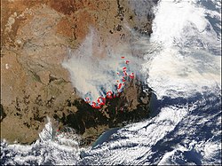
Burnt out bushland near Anglers Rest on the Omeo Highway, one of the worst hit areas
Location Alpine National Park and Mount Buffalo National Park in north-eastern Victoria, Australia
Statistics [1] [2]
Date(s)8 January 2003 (2003-01-08) 7 March 2003 (2003-03-07)
Burned area1,300,000 hectares (3,200,000 acres)
Cause Lightning
Land use Public land; national parks; rural and residential
Buildings destroyed
  • 41 homes
  • 213 other structures
  • Three bridges
  • 10,000 livestock
NASA photo of South-eastern Australia showing fire activity on 22 January 2003 Bushfires Australia Jan 22 2003.jpg
NASA photo of South-eastern Australia showing fire activity on 22 January 2003

The Eastern Victorian alpine bushfires were a series of bushfires in 2003 that burnt in the Alpine National Park and Mount Buffalo National Park in north-eastern Victoria, Australia. The bushfire started with eighty-seven fires that were started by lightning in the north east of Victoria on 8 January 2003. Eight of these fires were unable to be contained and joined to form the largest fire in Victoria since the 1939 "Black Friday" bushfires. [1]

The main fire burnt over 1,300,000 hectares (3,200,000 acres) over 59 days before it was contained on 7 March 2003. 41 homes and 213 other structures were destroyed, along with tree bridges, and 10,000 livestock were killed. Thousands of kilometres of fencing was also destroyed. This was the longest running fire until the 2006-07 Great Divide fires. [2]

In early February, at the peak of the fires, around 3,760 people were involved in the fire effort, excluding local Country Fire Authority brigades. This figure includes 160 Australian Defence Force staff, over 300 interstate firefighters, 33 alpine firefighting specialists from New Zealand and 35 personnel from the United States. In total, 15,725 personnel were directly engaged on fighting these bushfires.

The areas affected included, Mount Buffalo, Mount Bogong, Mount Feathertop, Bright, Dinner Plain, Benambra, Omeo, Cobungra, Shannonvale, Bundara, Anglers Rest, Sunnyside, Glen Wills, and Dargo.

See also

Related Research Articles

Alpine National Park Protected area in Victoria, Australia

The Alpine National Park is a national park located in the Central Highlands and Alpine regions of Victoria, Australia. The 646,000-hectare (1,600,000-acre) national park is located northeast of Melbourne. It is the largest National Park in Victoria, and covers much of the higher areas of the Great Dividing Range in Victoria, including Victoria's highest point, Mount Bogong at 1,986 metres (6,516 ft) and the associated subalpine woodland and grassland of the Bogong High Plains. The park's north-eastern boundary is along the border with New South Wales, where it abuts the Kosciuszko National Park. On 7 November 2008 the Alpine National Park was added to the Australian National Heritage List as one of eleven areas constituting the Australian Alps National Parks and Reserves.

Australian Alps Region in Australia

The Australian Alps is a mountain range in southeast Australia. It comprises an interim Australian bioregion, and is the highest mountain range in Australia. The range straddles the borders of eastern Victoria, southeastern New South Wales, and the Australian Capital Territory. It contains Australia's only peaks exceeding 2,000 m (6,600 ft) in elevation, and is the only bioregion on the Australian mainland in which deep snow falls annually. The range comprises an area of 1,232,981 ha.

Black Friday bushfires Series of bushfires in Australia in 1939

The Black Friday bushfires of 13 January 1939, in Victoria, Australia, were part of the devastating 1938–1939 bushfire season in Australia, which saw bushfires burning for the whole summer, and ash falling as far away as New Zealand. It was calculated that three-quarters of the State of Victoria was directly or indirectly affected by the disaster, while other Australian states and the Australian Capital Territory were also badly hit by fires and extreme heat. As of 3 November 2011, the event was one of the worst recorded bushfires in Australia, and the third most deadly.

Ash Wednesday bushfires 1983 brushfires in Australia

The Ash Wednesday bushfires, known in South Australia as Ash Wednesday II, were a series of bushfires that occurred in south-eastern Australia on 16 February 1983, which was Ash Wednesday. Within twelve hours, more than 180 fires fanned by hot winds of up to 110 km/h (68 mph) caused widespread destruction across the states of Victoria and South Australia. Years of severe drought and extreme weather combined to create one of Australia's worst fire days in a century. The fires were the deadliest bushfire in Australian history until the Black Saturday bushfires in 2009.

2006–07 Australian bushfire season Australian bushfire

One of the most extensive bushfire seasons in Australia's history. Victoria experienced the longest continuously burning bushfire complex in Australia's history, with fires in the Victorian Alps and Gippsland burning over 1 million hectares of land over the course of 69 days. See Bushfires in Australia for an explanation of regional seasons.

The Alpine Classic is an Australian bicycle event run every Australia Day weekend in Bright, Victoria. The event is currently managed by O2 Events, having previously been organised by Audax Australia volunteers. Arguably the most difficult single day cycle event in Australia with the 200 km version covering four steep climbs. All distances start at Howitt Park in Bright and are on open roads.

2008–09 Australian bushfire season

The Australian bushfire season ran from late December 2008 to April/May 2009. Above average rainfalls in December, particularly in Victoria, delayed the start of the season, but by January 2009, conditions throughout South eastern Australia worsened with the onset of one of the region's worst heat waves. On 7 February, extreme bushfire conditions precipitated major bushfires throughout Victoria, involving several large fire complexes, which continued to burn across the state for around one month. 173 people lost their lives in these fires and 414 were injured. 3,500+ buildings were destroyed, including 2,029 houses, and 7,562 people displaced.

2002–03 Australian bushfire season

A particularly extensive bushfire season in Australia, ran predominantly from December 2002 to March 2003 and involved over 3,000 separate fires in Victoria alone. The 2003 Canberra bushfires were also particularly severe.

2009–10 Australian bushfire season

A bushfire season occurred predominantly from June 2009 to May 2010. Increased attention has been given to this season as authorities and government attempt to preempt any future loss of life after the Black Saturday bushfires during the previous season, 2008–09. Long range weather observations predict very hot, dry and windy weather conditions during the summer months, leading to a high risk of bushfire occurrence.

Big River (Mitta Mitta River, Victoria)

The Big River, a perennial river of the North-East Murray catchment of the Murray-Darling basin, is located in the East Gippsland and alpine regions of Victoria, Australia. It flows from the northern slopes of Falls Creek in the Australian Alps, joining with the Cobungra River near Anglers Rest to form the Mitta Mitta River.

Bundara River

The Bundara River, a perennial river of the North-East Murray catchment of the Murray-Darling basin, is located in the East Gippsland and alpine regions of Victoria, Australia.

2011–12 Australian bushfire season

Bushfires were mostly active between September 2011 to March 2012 and caused most damage in the state of Western Australia, particularly in the South West. The state had been prepared and had expected an increased risk of bushfire following heavy spring rains as a result of a La Nina weather pattern.

2012–13 Australian bushfire season

The summer of 2012–13, had above average fire potential for most of the southern half of the continent from the east coast to the west. This is despite having extensive fire in parts of the country over the last 12 months. The reason for this prediction is the abundant grass growth spurred by two La Niña events over the last two years.

2014–15 Australian bushfire season

The bushfire season in the summer of 2014–15, was expected to have the potential for many fires in eastern Australia after lower than expected rainfall was received in many areas. Authorities released warnings in the early spring that the season could be particularly bad.

The Eastern Victoria Great Divide bushfires, also known as the Great Divide Complex, were a series of bushfires that commenced in the Victorian Alps in Australia on 1 December 2006 due to lightning strikes, and continued for 69 days. They were the longest running bushfires in the state's history. Between 1.2 and 1.3 million hectares were burnt, most of it public land. Victorian fire personnel were assisted by others from all states and territories of Australia, as well as teams from New Zealand, the United States and Canada.

2017–18 Australian bushfire season

The bushfire season of the summer of 2017–18, was expected to have above normal bushfire risks with an elevated fire risk for the most of eastern and south Australian coastal areas. Australia had experienced its warmest winter on record and the ninth driest winter on record leaving dry fuel loads across much of southern Australia. Expected warmer weather over the summer period would also increase the risk. Bushfires were also expected to occur earlier, before the end of winter, as a result of the warm and dry winter. Both Queensland and north-eastern New South Wales experienced the wettest October since 1975 leading to a downgrade in bushfire risk.

2018–19 Australian bushfire season

The bushfires were predicted to be "fairly bleak" in parts of Australia, particularly in the east, by the Bushfire and Natural Hazards Cooperative Research Centre (CRC) chief executive, Richard Thornton, in September 2018. Large bushfires had already burned through southern New South Wales during winter. The outlook for spring was of a higher likelihood of fires with a twice the normal chance of an El Nino for summer. Many parts of eastern Australia including Queensland, New South Wales and Gippsland, in Victoria, were already in drought. Above normal fire was also predicted for large parts of Southern Australia and Eastern Australia by the Bushfire and Natural Hazards CRC. The forecast noted that Queensland had recorded the ninth driest and fourth hottest period on record from April to November. New South Wales recorded the fourth hottest period and eighth driest on record, while Victoria experiences the 13th driest and seventh hottest period on record. Authorities in New South Wales brought forward the start of the bushfire season for much of the state from October 2018 to the beginning of August 2018.

2019–20 Australian bushfire season Bushfires in Australia

The 2019–20 Australian bushfire season, colloquially known as the Black Summer, was a period of bushfires in many parts of Australia, which, due to its unusual intensity, size, duration, and uncontrollable dimension, is considered a megafire.

References

  1. 1 2 "Past bushfires". Department of Sustainability and Environment . Government of Victoria. 10 January 2019. Archived from the original on 22 March 2012. Retrieved 30 January 2020.
  2. 1 2 "January 2003: Bushfire - Alpine Region and north-eastern Victoria". Australian Disaster Resilitance: Knowlefge hub. Australia Institute of Disaster Relief. n.d. Retrieved 30 January 2020.