
A supercell is a thunderstorm characterized by the presence of a mesocyclone, a deep, persistently rotating updraft. Due to this, these storms are sometimes referred to as rotating thunderstorms. Of the four classifications of thunderstorms, supercells are the overall least common and have the potential to be the most severe. Supercells are often isolated from other thunderstorms, and can dominate the local weather up to 32 kilometres (20 mi) away. They tend to last 2–4 hours.

Severe storms in Australia refers to the storms, including cyclones, which have caused severe damage in Australia.

Severe Tropical Cyclone Larry was a tropical cyclone that made landfall in Australia during the 2005–06 Southern Hemisphere tropical cyclone season. Larry originated as a low pressure system over the eastern Coral Sea on 16 March 2006, and was monitored by the Australian Bureau of Meteorology in Brisbane, Australia. The low-pressure area organised into a tropical cyclone two days later and quickly strengthened into a Category 4 storm on the Australian tropical cyclone scale. Larry made landfall in Far North Queensland close to Innisfail, on 20 March 2006, as a Category 5 tropical cyclone on the Australian scale, with wind gusts reaching 240 kilometres per hour (150 mph), before dissipating over land several days later.
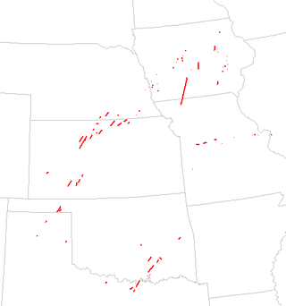
The tornado outbreak of April 10–11, 2001, was a large tornado outbreak which affected the central Great Plains on April 10–11, 2001. During the two-day outbreak, it produced a total of 79 tornadoes across eight states including Kansas, Missouri, Oklahoma, Texas, Nebraska, Iowa, Illinois and Michigan. Four people were killed, 18 injured, and more than $23 million in damage was reported. The fatalities were reported in Oklahoma, Iowa and Missouri including two from a single tornado in Wapello County, Iowa.
The 1999 Sydney hailstorm was the costliest natural disaster in Australian insurance history, causing extensive damage along the east coast of New South Wales. The storm developed south of Sydney on the afternoon of Wednesday, 14 April 1999, and struck the city's eastern suburbs, including the central business district, later that evening.
A series of destructive severe thunderstorms struck southeastern Queensland, Australia, on 29 November 1992. The storms produced strong winds, flash flooding and large hailstones in the region, including the capital city of Brisbane. The storms also spawned two of the most powerful tornadoes recorded in Australia, including the only Australian tornado to be given an official 'F4' classification on the Fujita scale and the last violent tornado in Australia until 21 March 2013.
The 1947 Sydney hailstorm was a natural disaster which struck Sydney, Australia, on 1 January 1947. The storm cell developed on the morning of New Year's Day, a public holiday in Australia, over the Blue Mountains, hitting the city and dissipating east of Bondi in the mid-afternoon. At the time, it was the most severe storm to strike the city since recorded observations began in 1792.

Severe Tropical Cyclone Ului was one of the fastest intensifying tropical cyclones on record, strengthening from a tropical storm to a Category 5 equivalent cyclone within a 30-hour span in March 2010. Throughout Queensland, Australia, infrastructural damage from the storm amounted to A$20 million (US$18 million) and agricultural losses reached A$60 million (US$54 million).

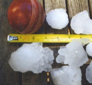
The 1995 Mayfest storm was a damaging hailstorm that struck parts of the Dallas–Fort Worth metroplex on May 5, 1995. It was the first singular thunderstorm with a damage toll exceeding $1 billion and at the time the costliest nontornadic thunderstorm in U.S. history. Hail up to 4.5 in (11.5 cm) in diameter fell across Parker and Tarrant counties, producing hail drifts as deep as 3 ft (0.91 m) and damaging numerous buildings. The storm also struck the Fort Worth Mayfest – a local outdoor festival – pelting the roughly 10,000 people in attendance with softball-sized hail and resulting in over 60 hospitalizations. Though there were no hail-related fatalities, the combination of the slow-moving supercell that produced the hail and a larger complex of storms led to deadly flash flooding that killed 17 people in the Dallas area. Overall, 20 people were killed by the storms.

A series of floods hit Queensland, Australia, beginning in November 2010. The floods forced the evacuation of thousands of people from towns and cities. At least 90 towns and over 200,000 people were affected. Damage initially was estimated at A$1 billion before it was raised to $2.38 billion. The estimated reduction in Australia's GDP is about A$30 billion. As of March 2012, there were 33 deaths attributed to the floods, with a further three people still missing.

Severe Tropical Cyclone Yasi was a powerful and destructive tropical cyclone that made landfall in northern Queensland, Australia in early 2011, causing major damage to the affected areas. Originating as a tropical low near Fiji on 26 January, the system intensified to tropical cyclone status during the evening of 30 January. Yasi deepened rapidly over the next 24 hours, and was classified as a Category 3 cyclone at about 5 PM AEST on 31 January 2011. Late on 1 February, the cyclone strengthened to a Category 4 system; then, early on 2 February, the cyclone intensified into a Category 5 Severe Tropical Cyclone. The system had a well-defined eye and continued to track west-southwestward, maintaining a central pressure of 930 hPa and a Dvorak intensity of T6.5 into the evening.

Severe Tropical Cyclone Jasmine was a powerful and long-lived annular tropical cyclone that affected several countries, particularly Vanuatu and Tonga, over a 16-day span in February 2012. The system was the second cyclone and the only severe tropical cyclone of the relatively quiet 2011–12 South Pacific cyclone season. Cyclone Jasmine developed from an area of disturbed weather on 1 February in the Gulf of Carpentaria. Initially, the storm moved towards the east and across the Cape York Peninsula. As it moved across the South Pacific, earlier existing wind shear conditions lessened, and Jasmine began to strengthen at a faster rate. Steadily intensifying, Jasmine reached peak intensity on 8 February as a Category 4 equivalent on the Saffir–Simpson Hurricane Scale, while beginning to show annular characteristics.

This page documents the tornadoes and tornado outbreaks of 2013. Strong and destructive tornadoes form most frequently in the United States, Bangladesh, Brazil and Eastern India, but they can occur almost anywhere under the right conditions. Tornadoes also appear regularly in neighboring southern Canada during the Northern Hemisphere's summer season, and somewhat regularly in Europe, Asia, and Australia.

Tropical Cyclone Oswald in 2013 was a tropical cyclone that passed over parts of Queensland and New South Wales, Australia over a number of days, causing widespread impact including severe storms, flooding, and water spouts. Coastal regions of Queensland were the most impacted with Mundubbera, Eidsvold, Gayndah and Bundaberg in the Wide Bay–Burnett hit severely. In many places the rainfall total for January set new records. Across the affected region, damage from severe weather and flooding amounted to at least A$2.4 billion.

Australian east coast lows are extratropical cyclones or low-pressure systems on the coast of southeastern Australia that may be caused by both mid-latitude and tropical influences over a variety of levels in the atmosphere. These storms should not be confused with Australian region tropical cyclones which typically affect the northern half of the continent.

Severe Tropical Cyclone Ita was the strongest tropical cyclone in the Australian region by central pressure since George in 2007, and by wind speed since Monica in 2006. The system was first identified over the Solomon Islands as a tropical low on 1 April 2014, and gradually moved westward, eventually reaching cyclone intensity on 5 April. On 10 April, Ita intensified rapidly into a powerful Category 5 system on the Australian Scale, but it weakened to a Category 4 system in the hours immediately preceding landfall the following day. At the time of landfall at Cape Flattery at 12 April 22:00 (UTC+10), the cyclone's Dvorak intensity was approximately T5.0, consistent with a weak Category 4 system, and considerably lower than the T6.5 observed when the system was at its peak intensity. Meteorologists noted the system had, at that time, begun an eyewall replacement cycle; as a result, the system was considerably less powerful than various intensity scales had predicted. As a result, Ita's impact on terrain was lessened.
Hailstorm Alley is a colloquial term referring to an area of south and central Alberta, Canada where hail storms are frequently produced. These storms frequently produce hail that is damaging to property. This area stretches from High River in southern Alberta, northward through Calgary, through Red Deer to Lacombe and then westward to Rocky Mountain House. It is known to be one of the worst areas in the world for damaging hail produced by thunderstorms. These are regarded as loose boundaries. While this area is common for damaging hailstorms, the reality is damaging hailstorms occur over much of central and southern Alberta every summer. The City of Calgary is regarded as the hailstorm capital of Canada.

Brisbane has a humid subtropical climate with year-round period with warm to hot temperatures. Brisbane generally experiences 3 months of mild cool winter from June to August.
