
Westport is a town in the West Coast region of the South Island of New Zealand. Established in 1861, it is the oldest European settlement on the West Coast. Originally named Buller, it is on the right bank and at the mouth of the Buller River, close by the prominent headland of Cape Foulwind. It is connected via State Highway 6 with Greymouth, 100 kilometres (62 mi) to the south, and with Nelson 222 kilometres (138 mi) in the northeast, via the Buller Gorge. The population of the Westport urban area was 4,250 as of June 2023. The Buller District had a population of 9,670.
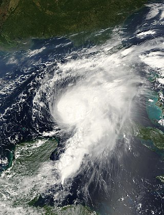
Hurricane Gordon caused minor damage in the Eastern United States. The seventh named storm and fourth hurricane of the 2000 Atlantic hurricane season, Gordon developed in the extreme western Caribbean Sea from a tropical wave on September 14. Shortly thereafter, the depression moved inland over the Yucatán Peninsula and later emerged into the Gulf of Mexico on September 15. The depression began to quickly organize, and by early on September 16, it was upgraded to Tropical Storm Gordon. After becoming a tropical storm, Gordon continued to intensify and was reclassified as a hurricane about 24 hours later; eventually, the storm peaked as an 80 mph (130 km/h) Category 1 hurricane. However, southwesterly upper-level winds caused Gordon to weaken as it approached land, and it was downgraded to a tropical storm by late on September 17. At 0300 UTC on September 18, Gordon made landfall near Cedar Key, Florida as a strong tropical storm. After moving inland, Gordon rapidly weakened and had deteriorated to tropical depression status by nine hours later. Later that day, Gordon merged with a frontal boundary while centered over Georgia.
Floods in the United States (2000–present) is a list of flood events which were of significant impact to the country during the 21st century, since 2000. Floods are generally caused by excessive rainfall, excessive snowmelt, storm surge from hurricanes, and dam failure.

All types of floods can occur in California, though 90 percent of them are caused by river flooding in lowland areas. Such flooding generally occurs as a result of excessive rainfall, excessive snowmelt, excessive runoff, levee failure, poor planning or built infrastructure, or a combination of these factors. Below is a list of flood events that were of significant impact to California.

The climate of New Zealand is varied due to the country's diverse landscape. Most regions of New Zealand belong to the temperate zone with a maritime climate characterised by four distinct seasons. Winters are relatively mild and summers comparatively cool. The main contributing factors are the Pacific Ocean and latitude, although the mountain ranges can cause significant climate variations in locations barely tens of kilometres from each other. Conditions vary from extremely wet on the West Coast of the South Island to almost semi-arid in Central Otago and subtropical in Northland.
The 1929 Murchison earthquake occurred at 10:17 am on 17 June. It struck the Murchison region of the South Island, with an estimated magnitude of 7.3, and was felt throughout New Zealand. There were 17 deaths, mostly as a result of landslides triggered by the earthquake. The rumbling sound of the earthquake was loud enough to be heard at New Plymouth, more than 250 km (155 mi) away.

The 2010 Gascoyne River flood was regarded as the most severe flood to take place along the Gascoyne River in Western Australia on record. Triggered by record-breaking rainfall, amounting to over 6,000 percent of the monthly mean, 313.6 mm (12.35 in) and 5 mm (0.20 in) respectively, in just four days, the floods caused widespread damage in the region. By 17 December, the river began to rise in response to the heavy rains, eventually exceeding its banks within two days. Water levels reached record values at three stations along the river, cresting at 15.53 m (51.0 ft) near Fishy Pool. Evacuation orders were issued for several towns affected by rising waters. The most substantial impact was felt in Carnarvon where entire homes were washed away. Following the disaster, emergency supplies and funds were distributed to affected residents to aid them in restoring their livelihoods. Though no people died in the event, an estimated two thousand head of cattle perished and damage was estimated at A$100 million.

Severe Tropical Cyclone Ita was the strongest tropical cyclone in the Australian region by central pressure since George in 2007, and by wind speed since Monica in 2006. The system was first identified over the Solomon Islands as a tropical low on 1 April 2014, and gradually moved westward, eventually reaching cyclone intensity on 5 April. On 10 April, Ita intensified rapidly into a powerful Category 5 system on the Australian Scale, but it weakened to a Category 4 system in the hours immediately preceding landfall the following day. At the time of landfall at Cape Flattery at 12 April 22:00 (UTC+10), the cyclone's Dvorak intensity was approximately T5.0, consistent with a weak Category 4 system, and considerably lower than the T6.5 observed when the system was at its peak intensity. Meteorologists noted the system had, at that time, begun an eyewall replacement cycle; as a result, the system was considerably less powerful than various intensity scales had predicted. As a result, Ita's impact on terrain was lessened.

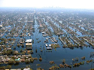
Hurricane Harvey was a devastating Category 4 hurricane that made landfall on Texas and Louisiana in August 2017, causing catastrophic flooding and more than 100 deaths. It is tied with 2005's Hurricane Katrina as the costliest tropical cyclone on record, inflicting $125 billion in damage, primarily from catastrophic rainfall-triggered flooding in the Houston metropolitan area and Southeast Texas; this made the storm the costliest natural disaster recorded in Texas at the time. It was the first major hurricane to make landfall in the United States since Wilma in 2005, ending a record 12-year span in which no hurricanes made landfall at the intensity of a major hurricane throughout the country. In a four-day period, many areas received more than 40 inches (1,000 mm) of rain as the system slowly meandered over eastern Texas and adjacent waters, causing unprecedented flooding. With peak accumulations of 60.58 in (1,539 mm), in Nederland, Texas, Harvey was the wettest tropical cyclone on record in the United States. The resulting floods inundated hundreds of thousands of homes, which displaced more than 30,000 people and prompted more than 17,000 rescues.

Severe Tropical Cyclone Gita was the most intense tropical cyclone to impact Tonga since reliable records began. The second named storm and first major tropical cyclone of the 2017–18 South Pacific cyclone season, Gita originated from a monsoon trough that was active in the South Pacific in early February 2018. First classified as a tropical disturbance on 3 February, the nascent system meandered near Vanuatu for several days with little development. After acquiring a steady east trajectory near Fiji, it organized into a Category 1 tropical cyclone on 9 February near Samoa. Arcing south in a clockwise turn, the system rapidly intensified, and became a severe tropical cyclone on 10 February near Niue.
Extreme rainfall on the east coast of Australia beginning on 18 March 2021 led to widespread flooding in New South Wales, affecting regions from the North Coast to the Sydney metropolitan area in the south. Suburbs of Sydney experienced the worst flooding in 60 years, and the events were described by NSW Premier Gladys Berejiklian as "one in 100-year" flooding. Far-southeast communities in Queensland were also affected by flooding and heavy rainfall, though to a lesser extent than those in New South Wales.

In July 2021, several European countries were affected by severe floods. Some were catastrophic, causing deaths and widespread damage. The floods started in the United Kingdom as flash floods causing some property damage and inconvenience. Later floods affected several river basins across Europe including Austria, Belgium, Croatia, Germany, Italy, Luxembourg, the Netherlands, and Switzerland. At least 243 people died in the floods, including 196 in Germany, 43 in Belgium, two in Romania, one in Italy and one in Austria.

The 2022 eastern Australia floods were one of the nation's worst recorded flood disasters with a series of floods that occurred from late February to early May in South East Queensland, the Wide Bay–Burnett and parts of coastal New South Wales. Brisbane suffered major flooding, along with the cities of Maryborough, Gympie, the Sunshine Coast, Caboolture, Toowoomba, Gatton, Ipswich, Logan City, the Gold Coast, Murwillumbah, Mullumbimby, Grafton, Byron Bay, Ballina, Lismore, the Central Coast and parts of Sydney.

Severe Tropical Cyclone Dovi was a powerful tropical cyclone across the Southern Pacific in February 2022. The system became the third named tropical cyclone of the 2021–22 South Pacific cyclone season. The storm first formed in the Australian basin on February 4 before crossing over into the South Pacific. The storm caused one death in New Caledonia, and several mudslides occurred in New Caledonia and Vanuatu. Dovi also caused flight cancellations and damage out of New Zealand.

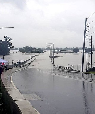
Heavy flooding broke out in the Central Coast and Sydney areas of New South Wales, Australia, beginning in early July 2022. Around 85,000 people were displaced by the flooding or requested to leave their homes by authorities. The floods' damage was significant because rain fell on land that was already saturated after months of previous heavy rainfall. It was the third major flood in 2022 for some areas in the eastern seaboard.

Beginning on Friday, 27 January 2023, regions across the upper North Island of New Zealand experienced widespread catastrophic floods caused by heavy rainfall, with Auckland being the most significantly affected as the Auckland Anniversary holiday weekend began.

Severe Tropical Cyclone Gabrielle was a severe tropical cyclone that devastated parts of the North Island of New Zealand and affected parts of Vanuatu and Australia in February 2023. It is the costliest tropical cyclone on record in the Southern Hemisphere, with total damages estimated to be at least NZ$13.5 billion (US$8.4 billion), of which the cost of insured damage is at least NZ$1.73 billion (US$1.07 billion). The total cost in the Hastings District alone is estimated to surpass NZ$2 billion (US$1.25 billion). It was also the deadliest cyclone and weather event overall to hit New Zealand since Cyclone Giselle in 1968, surpassing Cyclone Bola in 1988. The fifth named storm of the 2022–23 Australian region cyclone season, and the first severe tropical cyclone of the 2022–23 South Pacific cyclone season, Gabrielle was first noted as a developing tropical low on 6 February 2023, while it was located on the south of the Solomon Islands, before it was classified as a tropical cyclone and named Gabrielle by the Bureau of Meteorology. The system peaked as a Category 3 severe tropical cyclone before moving into the South Pacific basin, then rapidly degenerated into a subtropical low on 11 February 2023.
The 2023 southern New Zealand floods were caused by heavy rain that struck the southern part of New Zealand's South Island on 21 September 2023. This storm caused flooding in several places across the Southland and Otago regions including Gore and Queenstown. 100 homes were evacuated in Queenstown and Tuatapere's water treatment plant was damaged. A state of emergency was declared in the Southland Region. In addition, a state of emergency was declared in Queenstown on 22 September, which recorded its wettest day in 24 years.
On 3 June 2015, a low weather system brought heavy rain to the coastal Otago Region particularly South Dunedin. South Dunedin experienced heavy flooding, which was exacerbated by the area's high water table and the breakdown of the Portobello pumping station. 1,200 homes and businesses were damaged by flood damage. The Dunedin City Council (DCC) described the 3 June 2015 flood event as a "one in a 100 year" flood, with about 175mm of rain falling during a 24-hour period. The DCC subsequently drew criticism for the poor state of the city's storm water infrastructure.