
The 4th arrondissement of Paris is one of the twenty arrondissements of the capital city of France. In spoken French, this arrondissement is referred to as quatrième. Along with the 1st, 2nd and 3rd arrondissements, it is in the first sector of Paris, which maintains a single local government rather than four separate ones.

Line A is a line on the Lyon Metro that runs between Perrache and Vaulx-en-Velin–La Soie. It was constructed using the cut-and-cover method, and went into service on 2 May 1978. It, together with Line B, were the inaugural lines of the Lyon Metro. An extension of Line A from Laurent Bonnevay–Astroballe to Vaulx-en-Velin–La Soie opened in 2007. The line currently serves 14 stations, and is 9.2 kilometres (5.7 mi) long. Line A trains run on tires rather than steel wheels; it is a rubber-tired metro line.

Place Bellecour is a large square in the centre of Lyon, France, to the north of the Ainay district. Measuring 312 m by 200 m, it is one of the largest open squares in Europe, and the third biggest square in France, behind the Place des Quinconces in Bordeaux (12.6 ha) and the Place de la Concorde in Paris (8.6 ha). It is also the largest pedestrian square in Europe: vehicles are allowed on the Place de la Concorde and Place des Quinconces.
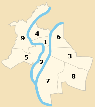
The nine arrondissements of Lyon are the administrative divisions of the City of Lyon. Unlike the spiral pattern of the arrondissements of Paris, or the meandering pattern of those in Marseille, the layout in Lyon is more idiosyncratic. This is for historical reasons: following the annexation of the communes of La Guillotière, La Croix-Rousse and Vaise in 1852, the newly enlarged city was divided into 5 arrondissements, which originally spiralled out anticlockwise from the Hôtel de Ville ; however, as the city's population expanded, it became necessary to split certain arrondissements, giving rise to today's seemingly random pattern.

Lyon, traditionally spelled in English as Lyons, is the third-largest city of France. It is located at the confluence of the rivers Rhône and Saône, to the northwest of the French Alps, 391 km (243 mi) southeast of Paris, 278 km (173 mi) north of Marseille, 113 km (70 mi) southwest of Geneva, 58 km (36 mi) northeast of Saint-Étienne.

The Lyon tramway comprises eight lines, seven lines operated by TCL and one by Rhônexpress in the city of Lyon in Auvergne-Rhône-Alpes, France. The original tramway network in Lyon was developed in 1879, and the modern network was built in 2001.
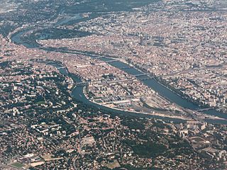
The Presqu'île is the central part of the City of Lyon, France. Extending from the foot of the Croix-Rousse hill in the north to the confluence of the Rhône and the Saône rivers in the south, it has a preponderance of cafés, restaurants, luxury shops, department stores, banks, government buildings and cultural institutions.
The 1st arrondissement of Lyon is one of the nine arrondissements of the City of Lyon. It is located below the hill of Croix-Rousse and on the north part of the Presqu'île formed by the Saône and the Rhône, the two rivers in Lyon.

The Rue de la République is a street located in the 1st and 2nd arrondissements of Lyon, France. It links the Place de la Comédie in the north to Place Le Viste in the south, just next to Place Bellecour, via the Place de la République.
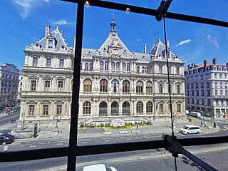
The Palais de la Bourse or Palais du Commerce is a building located in the quarter Les Cordeliers, in 2nd arrondissement of Lyon. It currently houses the headquarters of the Chamber of Commerce and Industry of Lyon. It is served by the metro station Cordeliers, and by bus lines C3,13, 18, 23, 25, 28, 58, 71, 91 and 99.

Rue Victor-Hugo is a pedestrian street in the 2nd arrondissement of Lyon, in the Ainay district of the Presqu'île quarter, reputed to be one of the most known shopping area of Lyon. From north to south, it connects the Place Bellecour to the Place Carnot. Beyond the Place Bellecour, the rue de la République is its natural extension, thus creating one of the biggest pedestrian streets in Europe. The street is served by metro stations Perrache, Bellecour and Ampère - Victor Hugo. It belongs to the zone classified as World Heritage Site by UNESCO.
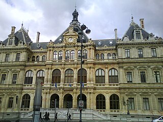
Les Cordeliers is one of the central quarters in the 2nd arrondissement of Lyon, France. It is mainly known for the Place des Cordeliers in its centre. Around the square, there are many notable monuments, including the Église Saint-Bonaventure and the Palais de la Bourse.

The Place Carnot is a square located in the Perrache quarter, in the 2nd arrondissement of Lyon.

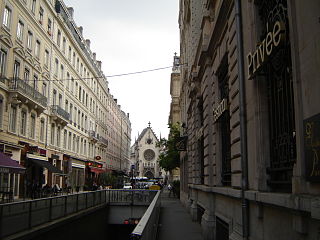
The Rue des Archers is a street located in the 2nd arrondissement of Lyon, in the Cordeliers quarter. It is near the Place Bellecour. The traffic goes from the rue Édouard-Herriot to the place des Célestins, and is regulated on the part leading to the rue de la République. The zone is served by the metro station Bellecour of the line A and the buses 91 and 99.

The Cours Charlemagne is a large central street located in the Perrache quarter, in the 2nd arrondissement of Lyon. This street is dedicated to Charlemagne, who came several times to Lyon. In addition, the bishop Leidrade represented the emperor in the city and by his great work of reconstruction. The Cours Charlemagne begins Place des Archives, just at the south of the vaults of the interchange of Perrache. It ends on the Quai Perrache, which overlooks the Pont Pasteur.
The Rue de la Bourse is a street located mainly in the 2nd arrondissement of Lyon, and also in the 1st arrondissement. It starts on the Place des Cordeliers, in the 2nd arrondissement, in front of the Église Saint-Bonaventure, and ends at right angles to the Rue du Bât-d'Argent, beyond which it is extended by the Rue du Garet.
The Rue Édouard-Herriot is one of the most important shopping streets of the Presqu'île in Lyon. It links the two most famous places of the city, the Place Bellecour (south) and the Place des Terreaux (north). Its northern part is located in the 1st arrondissement of Lyon, but the main part of the street is in the 2nd arrondissement. In its southern part, the street passes through the Place des Jacobins. It belongs to the zone classified as World Heritage Site by UNESCO.
The Boulevard des Belges is a wide and posh avenue located in Les Brotteaux quarter, in the 6th arrondissement of Lyon. It begins with the Quai de Grande Bretagne, runs along the southern part of the Parc de la Tête d'Or until the Avenue Verguin and ends on the Place Jules Ferry, in front of the Gare des Brotteaux. The boulevard is lined with plane trees and is served by two velo'v stations and the line B of the metro.


