
The London Borough of Barnet is a local authority area on the northern outskirts of London. The borough was formed in 1965 from parts of the ceremonial counties of Middlesex and Hertfordshire. It is the second largest London borough by population with 389,344 inhabitants as of 2021, also making it the 17th largest district in England. The borough covers an area of 86.74 square kilometres (33 sq mi), the fourth highest of the 32 London boroughs, and has a population density of 45.8 people per hectare, which ranks it 25th.

Chipping Barnet or High Barnet is a suburban market town in north London, forming part of the London Borough of Barnet, England. It is a suburban development built around a 12th-century settlement, and is located 10+1⁄2 miles (17 km) north-northwest of Charing Cross, 3 miles (4.8 km) east from Borehamwood, 5.2 miles (8.4 km) west from Enfield and 3.2 miles (5.1 km) south from Potters Bar. Its population, including its localities East Barnet, New Barnet, Hadley Wood, Monken Hadley, Cockfosters and Arkley, was 47,359 in 2011.

Chipping Barnet is a constituency created in 1974 and represented in the House of Commons of the UK Parliament since 2024 by Dan Tomlinson of the Labour Party. It is part of the London Borough of Barnet, on the border with Hertfordshire.

Finchley and Golders Green is a constituency created in 1997. It is represented in the House of Commons of the UK Parliament by Sarah Sackman of the Labour Party.
Barnet was a local government district in south Hertfordshire from 1863 to 1965 around the town of Barnet.
The London Borough of Barnet, located on the northern periphery of London and having much of the area within its boundaries in the Metropolitan Green Belt, has many parks and open spaces. In addition there are large areas taken over by cemeteries and golf courses, and part of Hampstead Heath.

Barnet Gate is a hamlet on the northern edge of the London Borough of Barnet to the west of Arkley, in England. There was a settlement there during the Roman occupation of Britain and in the Anglo-Saxon period it was known as Grendeles Gatan after Grendel, the monster in the epic poem Beowulf. Manor courts were held there and brickmaking was an important local industry. It was on the edge of Southaw wood which was cleared when nearby Chipping Barnet was developed after which it was known as Barnet Gate. The Gate referred to no longer exists but was either a gate used to prevent cattle straying onto Barnet Common or a gate that marked the boundary between Hertfordshire and Middlesex.

Ossulston House is a Grade II listed building opposite Joslin's Pond in Hadley Green Road, Hadley, to the north of Chipping Barnet. It is one of what was an almost complete line of houses between Chipping Barnet and Monken Hadley along the east side of Hadley Green which were built in the 18th and 19th centuries as wealthy merchants from London populated the area.
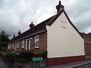
Garrett's Almshouses are Grade II listed almshouses on Wood Street, Chipping Barnet. The houses were constructed in 1729.

The Ravenscroft Cottages, also known as Jesus Hospital, are grade II listed almshouses in Wood Street, Chipping Barnet. The houses were built in 1672 but rebuilt in the 19th century.

Barnet United Reformed Church is a church in Wood Street, Chipping Barnet, London.

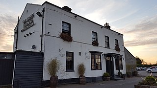
The Red Lion is a grade II listed public house in the High Street, Chipping Barnet, London.

The Mitre Inn is a public house at 58 High Street, Chipping Barnet, London. It was established by 1633 and is probably the oldest remaining of the town's once numerous coaching inns. It is a grade II listed building with Historic England and is currently styled "Ye Olde Mitre Inne".

The Chipping Barnet War Memorial is located immediately west of St John the Baptist Church in Wood Street, Chipping Barnet, Greater London. It commemorates the men and women of the district who died in the first and second World Wars and is in the form of an octagonal base below a pedestal surmounted by a tapering column with a Celtic cross head. The cross is intersected by a corona in a flattened octagonal section. It was unveiled by Lord Byng of Vimy in April 1921. Byng was born at nearby Wrotham Park in Hertfordshire.

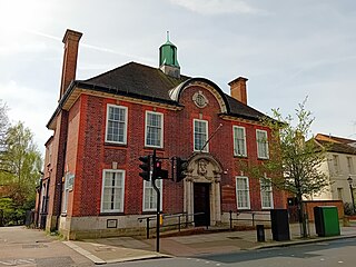
Tudor Hall in Wood Street, Chipping Barnet, is the original site of Queen Elizabeth's School, Barnet. It was built around 1577 following the granting of a charter for the school by Queen Elizabeth I in 1573 and is a grade II listed building with Historic England.

The Duke of York is a former coaching inn at Ganwick Corner on the section of the Great North Road now known as Barnet Road, between Chipping Barnet and Potters Bar in Hertfordshire, England. It is Grade II listed.

Whalebones Park is a 14-acre area of fields and woods in Chipping Barnet, London Borough of Barnet, England, between Barnet Hospital and Wood Street.
The Green Dragon is a Grade II listed public house in St Albans Road, Dancers Hill, Hertfordshire, England, on the road north from Chipping Barnet. It dates from around 1830 and is built of brick with a slate roof.

Hadley is a district of the London Borough of Barnet between Chipping Barnet in the south and Monken Hadley in the north. It was formerly a civil parish of Barnet Urban District.

Barnet Common was an area of common land to the south of the town of Chipping Barnet in what is now north London. The Common was created after a wood was cleared in the 16th century and was mostly used by local people to graze their animals. It was the location of a Digger colony and of the Barnet Physic Well at which mineral water was consumed. Part of the Common was enclosed in 1729 and the rest in 1815, leading to development on the north and south sides, and later infilling.

