946 eruption of Paektu Mountain

Last updated

946 eruption of Paektu Mountain
Millenium-Eruption-map.jpg
Volcano Paektu Mountain
Datelate 946 CE
Type Plinian
Location Jilin, China and Ryanggang Province, North Korea
VEI 6 [1]
ImpactAt least short-term regional climate changes

Paektu Mountain, also known as Changbaishan, on the border of the Democratic People's Republic of Korea and China [1] erupted in late 946 CE. [2] [3] This event is known as the Millennium Eruption or Tianchi eruption [4] and it was one of the most powerful volcanic eruptions in recorded history and is classified as a Magnitude 6.5-7 (or VEI-6) eruption. [5] [6] [7]

Contents

The eruption ejected about 13–47 cubic kilometres [5] [6] [7] of magma (dense rock equivalent) and formed a caldera, which now contains a lake (Heaven Lake). The eruption had two phases that each included a Plinian fallout and a pyroclastic flow and erupted magmas that were different in composition. [8] An average of 5 cm (2.0 in) of Plinian ashfall and co–ignimbrite ashfall covered about 1,500,000 km2 (580,000 sq mi) of the Sea of Japan and northern Japan. [9] [10] This ash layer has been named the "Baegdusan-Tomakomai ash" (B-Tm) [9] and is valuable marker horizon for correlating regional sedimentary archives in and around the Sea of Japan. The Millennium Eruption was one of the largest and most powerful eruptions in the last 5,000 years, along with the Minoan eruption of Thera, the Hatepe eruption of Lake Taupō (around 230 CE), the 431 CE eruption of Lake Ilopango, 1257 eruption of Mount Samalas near Mount Rinjani, and the 1815 eruption of Mount Tambora.

The date of the Millennium Eruption

The eruption ash layer is invaluable marker horizon for dating and correlating regional to global sedimentary archives, as evidence of the eruption is found throughout the Sea of Japan. Therefore, the timing of this eruption was one of the most intensely studied subject in the volcanology of Paektu Mountain, before its final settlement in the late 946 CE.

Radiocarbon dating

A precise radiocarbon date for the Millennium Eruption was achieved by obtaining numerous radiocarbon measurements across the stumps of trees that were felled and carbonised during the eruption. These radiocarbon measurements were wiggle-matched onto the calibration curve to constrain the date to between to 938–946 CE. Further constraints on the date were obtained when the major 774-775 CE carbon-14 spike (Miyake event) was identified in one of the tree stumps felled by the eruption. Exactly 172 rings were counted between this 774-775 CE Miyake event and the bark edge implying that the tree was killed in 946 CE. This date supports that obtained from the Greenland ice core age model. The comenditic and trachytic volcanic glass shards with chemical fingerprints associated with the Millennium eruption were located in the Greenland ice core, and the position corresponds to a date of 946–947 CE. The tree stump with preserved rings and the 774-775 CE Miyake event, and the identification of the tephra layer in the precisely dated Greenland ice cores indicate an unambiguous date of 946 CE for the Millennium Eruption.

Historical accounts

Several meteorological phenomena recorded in ancient Korea and Japan during the mid-10th century may have been caused by the Millennium Eruption. The Nihon Kiryaku (Japan Chronicle):

On 19 February 944 CE, around midnight, shaking, sounds above.

Another similar but later record from the Goryeosa (History of Goryeo) describes, at the palace in Kaesŏng, of a loud disturbance:

In the first year of the reign of Emperor Jeongjong (946 CE), heaven's drums sounded. That year the sky rumbled and cried out, there was an amnesty.

Kaesŏng is approximately 470 km from Paektu volcano, a distance over which the Millennium Eruption may have been heard. In addition, the Heungboksa Temple History (Annals of Kōfukuji) recorded a particularly interesting observation in Nara, Japan: [11]

On 3 November 946 CE, evening, white ash fell gently like snow.

The "white ash" may have been the white, comenditic, first phase of the B-Tm ash fall. [11] Three months later, the Dai Nihon Kokiroku (Old Diaries of Japan) and Nihon Kiryaku (Japan Chronicle) both documented a loud disturbance on the same day: [11]

On 7 February 947 CE, there was a sound in the sky, like thunder.

Ice-core and tree-ring

Ice core chronology [12] and tree ring dating allows extremely precise dating to the exact calendar year of any ice depth in the Common Era or any tree ring with virtually no age uncertainty. Rhyolitic and trachytic volcanic glass shards with chemical fingerprints of that of Millennium magma were found at an ice depth dated precisely to 946–947 CE, effectively confirming that the eruption occurred within the last 3 months of 946 CE. [12] [13]

Further confirmation came from studies of tree rings from a subfossil larch that was engulfed and killed during the initial explosive eruption. The tree was alive and recorded the atmospheric chemical changes during the major 774 CE carbon-14 spike. Between this event and the outermost ring, there are exactly 172 rings, implying that the tree was killed in 946 CE. This provides an unambiguous date for the Millennium Eruption. [2]

Eruption dynamics

Extensive studies of the sedimentary record of the Millennium Eruption revealed that the eruption had two phases, both generating widespread tephra fallout and pyroclastic flows. [10] [14] The first phase began with a Plinian eruption that produced widely dispersed comenditic tephra followed by unwelded pyroclastic flows and surges. After a hiatus of unknown duration, the second phase produced trachytic agglutinates and welded pyroclastic flow and surge deposits.

Phase 1 (comendite magma)

The first phase began with a stable Plinian eruption column which was estimated to have reached a height of 30–40 km [7] and produced a widely dispersed layer of light coloured pumice fallout. [7] The pumice fallout layer is then immediately overlain, no co-occurring as indicated by lack of interbedding, by massive pyroclastic flows that covered an area of 2,000 km2 (770 square miles) with an average thickness of 5 m (16 feet) and reached a distance as far as 50 km (31 miles). These pyroclastic flows were generated by the collapse of the Plinian eruption column. A co-ignimbrite ash layer, generated from elutriation during pyroclastic flow, overlies the pyroclastic flows, representing the topmost deposition from this eruption phase. The magma composition of this phase was predominantly comenditic and of distinct light grey colour. The mass eruption rate of this phase has been estimated to be 1-4 × 10⁸ kg/s. [7] Based on the historical records of falling white ash in Nara, it is suggested that the first phase may have started on 2 November 946 CE.

Phase 2 (trachyte magma)

There are still disputes over what pyroclastic products were emplaced during the second phase, and whether there was a significant period of quiescence between the first and the second phase. At multiple locations, non-pyroclastic materials or erosion separates the first and second phase eruptive products, indicating an eruption hiatus.

Unlike the first phase, this phase began with pulsing eruptions from non-sustained columns characterised by frequent column collapses, depositing multiple tephra fall units of alternating colour and interbedded with co-occurring pyroclastic flows from column collapsing. As many as seven fall units are recognised in this phase. Fallout were also deposited as high-temperature agglutinates mantling the inner caldera wall. The pyroclastic flows of this phase filled paleovalleys in all directions within a radius of 20 km (12 miles) of the caldera. The uppermost part of the second phase deposits is also a co-ignimbrite ash layer. There was widespread ash dispersal associated with this trachytic phase, [9] [10] and modelling suggests that the eruption plume extended >30 km in altitude and the mass eruption rate was larger than 108 kg/s. [7]

Eruption volume

Based on the proximal and distal thicknesses of the deposit it, was estimated that the fallout volume was between 13.4 and 37.4 km3 Dense Rock Equivalent (DRE) of magma, and the PDC volume was around 6.2-7.8 km3 DRE. [6] These estimates place the bulk volume of the eruption to be between 40.2 and 97.7 km3, which equates to 17.5 to 42.5 km3 DRE magma (using a tephra deposit density of 1000 kg/m3 and a magma density of 2300 kg/m3). Tephra dispersal models were recently used with tephra fallout thicknesses from both phases to constrain the eruption parameters and volumes of the two separate phases. [7] Between 3 and 16 km3 (best estimate of 7.2 km3) of DRE magma was dispersed by the first comenditic phase, and 4-20 km3 (best estimate of 9.3 km3) during the second trachytic phase of the eruption. [7] When the PDC volumes are considered with these updated fallout volumes, the total volumes are around 23 km3 DRE magma – similar to the amount of material removed from the edifice to generate a caldera. [7]  

Volatile release

Large volcanic eruptions can inject a large amount of volatiles and aerosols into the atmosphere, leading to volcanic winter and environmental changes. [15]

The amount of volatiles released by an eruption, such as F, Cl and S, is assessed by taking the amount of the volatile element dissolved in the magma when it was crystallising and taking off the amount still in the magma when it erupted. Blebs of magma often become trapped in the crystals during crystallisation forming melt inclusions, which are analysed to determine the original volatile concentration. The remaining amount of the volatile dissolved in the melt is established by analysing the matrix glass – the magma quenched on eruption. The difference in the volatile element between the MI and matrix glass is then multiplied by the volume of the melt to estimate the amount of the volatiles that are released into the atmosphere. [15]

F, Cl and S contents of MI and matrix glasses have been measured for the comenditic magma erupted in the first phases of the eruption. [16] [17] [18] [19] Using these average volatile contents in the MI and matrix glass combined with the comendite magma volume (3-17 km3 DRE) the volatile release was between 5 and 30 Tg S, 6-32 Tg F, and 2-15 Tg Cl. [7] The F and Cl contents of MI and matrix glasses cover a similar range, suggesting the melts were probably not saturated in F or Cl, and loss of these volatile phases could be negligible. [7] The low S yield is consistent with ice core records that estimated the S load was ~2 Tg based on the non-sea salt sulphate record, [20] and the limited climate impact recorded in palaeoenvironmental and palaeoclimate proxies [2]

Climate effects

The Millennium Eruption is thought to have emitted an enormous mass of volatiles into the stratosphere, likely resulting in a major worldwide climatic impact, though more recent studies indicate that the Millennium Eruption of Mt. Paektu volcano may have been limited to regional climatic effects. [21] [5] [13] [12] However, there are some meteorological anomalies in A.D. 945–948 which may relate to the Millennium Eruption. [22] The event is thought to have caused a volcanic winter.

DateMeteorological AnomalySource
4. Apr, 945It snowed heavily Old History of the Five Dynasties
28. Nov, 946 Glaze ice Old History of the Five Dynasties
7. Dec, 946Large scale frost and fog, and rime covered all plantsOld History of the Five Dynasties
31. Jan, 947It snowed over ten days, and caused inadequate food supply and famine Old History of the Five Dynasties, Zizhi Tongjian
24. Feb, 947 until 23. Apr, 947Warm springJapanese historical meteorological materials
14. May, 947Frost, and cold as harsh winterJapanese historical meteorological materials
16. Dec, 947Glaze iceOld History of the Five Dynasties
25. Dec, 947Glaze iceOld History of the Five Dynasties
6. Jan, 948Glaze iceOld History of the Five Dynasties
24. Oct, 948It snowed in Kaifeng Old History of the Five Dynasties

See also

Related Research Articles

<span class="mw-page-title-main">Paektu Mountain</span> Mountain on the China–North Korea border

Paektu Mountain or Baekdu Mountain is an active stratovolcano on the Chinese–North Korean border. In China, it is known as Changbai Mountain. At 2,744 m (9,003 ft), it is the tallest mountain in North Korea and Northeast China and the tallest mountain of the Baekdu-daegan and Changbai mountain ranges. The highest peak, called Janggun Peak, belongs to North Korea. The mountain notably has a caldera that contains a large crater lake called Heaven Lake, and is also the source of the Songhua, Tumen, and Yalu rivers. Korean and Manchu people assign a mythical quality to the mountain and its lake, and consider the mountain to be their ancestral homeland.

<span class="mw-page-title-main">Novarupta</span> Volcano in Katmai National Park, Alaska, US

Novarupta is a volcano that was formed in 1912, located on the Alaska Peninsula on a slope of Trident Volcano in Katmai National Park and Preserve, about 290 miles (470 km) southwest of Anchorage. Formed during the largest volcanic eruption of the 20th century, Novarupta released 30 times the volume of magma of the 1980 eruption of Mount St. Helens.

<span class="mw-page-title-main">Pyroclastic rock</span> Clastic rocks composed solely or primarily of volcanic materials

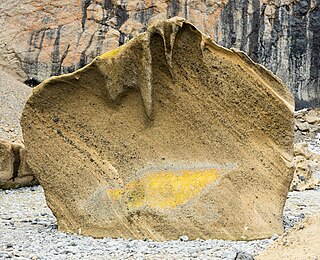
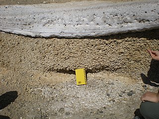
Pyroclastic rocks are clastic rocks composed of rock fragments produced and ejected by explosive volcanic eruptions. The individual rock fragments are known as pyroclasts. Pyroclastic rocks are a type of volcaniclastic deposit, which are deposits made predominantly of volcanic particles. 'Phreatic' pyroclastic deposits are a variety of pyroclastic rock that forms from volcanic steam explosions and they are entirely made of accidental clasts. 'Phreatomagmatic' pyroclastic deposits are formed from explosive interaction of magma with groundwater. The word pyroclastic is derived from the Greek πῦρ, meaning fire; and κλαστός, meaning broken.

<span class="mw-page-title-main">Tephra</span> Fragmental material produced by a volcanic eruption

Tephra is fragmental material produced by a volcanic eruption regardless of composition, fragment size, or emplacement mechanism.

<span class="mw-page-title-main">Mount Tarawera</span> Volcano in New Zealand

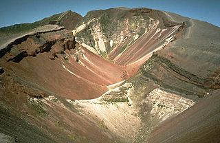
Mount Tarawera is a volcano on the North Island of New Zealand within the older but volcanically productive Ōkataina Caldera. Located 24 kilometres southeast of Rotorua, it consists of a series of rhyolitic lava domes that were fissured down the middle by an explosive basaltic eruption in 1886. While the 1886 eruption was basaltic, study has shown there was only a small basalt component to the previous recent rhyolitic predominant eruptions. This eruption was one of New Zealand's largest historical eruptions, and killed an estimated 120 people. The fissures run for about 17 kilometres (11 mi) northeast–southwest.

<span class="mw-page-title-main">Kikai Caldera</span> Mostly-submerged caldera in the Ōsumi Islands of Kagoshima Prefecture, Japan

Kikai Caldera is a massive, mostly submerged caldera up to 19 kilometres (12 mi) in diameter in the Ōsumi Islands of Kagoshima Prefecture, Japan.

<span class="mw-page-title-main">Plinian eruption</span> Type of volcanic eruption

Plinian eruptions or Vesuvian eruptions are volcanic eruptions marked by their similarity to the eruption of Mount Vesuvius in 79 AD, which destroyed the ancient Roman cities of Herculaneum and Pompeii. The eruption was described in a letter written by Pliny the Younger, after the death of his uncle Pliny the Elder.

<span class="mw-page-title-main">Aira Caldera</span> Large flooded coastal volcanic caldera in Japan

Aira Caldera is a gigantic volcanic caldera that is located on the southern end of Kyushu, Japan. It is believed to have been formed about 30,000 years ago with a succession of pyroclastic surges. It is currently the place of residence to over 900,000 people. The shores of Aira Caldera are home to rare flora and fauna, including Japanese bay tree and Japanese black pine. The caldera is home to Mount Sakurajima, and the Mount Kirishima group of stratovolcanoes lies to the north of the caldera. The most famous and active of this group is Shinmoedake.

<span class="mw-page-title-main">Strombolian eruption</span> Type of volcanic eruption with relatively mild explosive intensity

In volcanology, a Strombolian eruption is a type of volcanic eruption with relatively mild blasts, typically having a Volcanic Explosivity Index of 1 or 2. Strombolian eruptions consist of ejection of incandescent cinders, lapilli, and volcanic bombs, to altitudes of tens to a few hundreds of metres. The eruptions are small to medium in volume, with sporadic violence. This type of eruption is named for the Italian volcano Stromboli.

<span class="mw-page-title-main">Kuwae</span> Submarine caldera between the Epi and Tongoa islands in Vanuatu

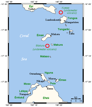
Kuwae was a landmass that existed in the vicinity of Tongoa and was destroyed by volcanic eruption in fifteenth century, probably through caldera subsidence. The exact location of the caldera is debated. A submarine caldera, now known as Kuwae caldera that is located between the Epi and Tongoa islands is a potential candidate. Kuwae Caldera cuts through the flank of the Tavani Ruru volcano on Epi and the northwestern end of Tongoa. Another potential candidate is a proposed caldera between Tongoa and Tongariki.

<span class="mw-page-title-main">Oruanui eruption</span> Worlds most recent supereruption, of Taupō Volcano, New Zealand

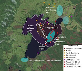
The Oruanui eruption of New Zealand's Taupō Volcano was the world's most recent supereruption, and largest phreatomagmatic eruption characterised to date.

<span class="mw-page-title-main">Types of volcanic eruptions</span> Overview of different types of volcanic eruptions

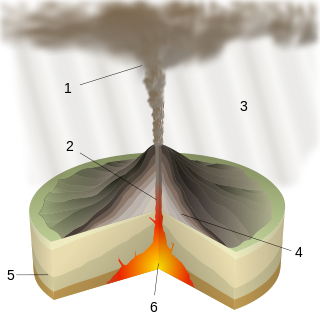
Several types of volcanic eruptions—during which material is expelled from a volcanic vent or fissure—have been distinguished by volcanologists. These are often named after famous volcanoes where that type of behavior has been observed. Some volcanoes may exhibit only one characteristic type of eruption during a period of activity, while others may display an entire sequence of types all in one eruptive series.

<span class="mw-page-title-main">Phreatomagmatic eruption</span> Volcanic eruption involving both steam and magma

Phreatomagmatic eruptions are volcanic eruptions resulting from interaction between magma and water. They differ from exclusively magmatic eruptions and phreatic eruptions. Unlike phreatic eruptions, the products of phreatomagmatic eruptions contain juvenile (magmatic) clasts. It is common for a large explosive eruption to have magmatic and phreatomagmatic components.

<span class="mw-page-title-main">Hatepe eruption</span> Major eruption of Taupō volcano

The Hatepe eruption, named for the Hatepe Plinian pumice tephra layer, sometimes referred to as the Taupō eruption or Horomatangi Reef Unit Y eruption, is dated to 232 CE ± 10 and was Taupō Volcano's most recent major eruption. It is thought to be New Zealand's largest eruption within the last 20,000 years. The eruption ejected some 45–105 km3 (11–25 cu mi) of bulk tephra, of which just over 30 km3 (7.2 cu mi) was ejected in approximately 6–7 minutes. This makes it one of the largest eruptions in the last 5,000 years, comparable to the Minoan eruption in the 2nd millennium BCE, the 946 eruption of Paektu Mountain, the 1257 eruption of Mount Samalas, and the 1815 eruption of Mount Tambora.

<span class="mw-page-title-main">Akahoya eruption</span> Ultra-Plinian eruption in Kyushu, Japan, at around 6,500 BP

The Akahoya eruption or Kikai-Akahoya eruption was the strongest known volcanic eruption of the Kikai Caldera in Kyūshū, Japan. It ejected 332–457 km3 (80–110 cu mi) of volcanic material, giving it a Volcanic Explosivity Index of 7.

<span class="mw-page-title-main">Aso Caldera</span> Caldera in Kumamoto Prefecture, Japan

Aso caldera is a geographical feature of Kumamoto Prefecture, Japan. It stretches 25 kilometers north to south and 18 kilometers east to west. The central core "Aso Gogaku" is the five major mountains in the area. Aso valley (Asodani) runs along the northern base of Mount Aso and Nango valley (Nangodani) along the south. According to research of caldera sediment, lakes used to exist in these valleys. The dried up lake areas have come to be called Old Aso Lake, Kugino Lake, and Aso Valley Lake. The Kikuchi, Shirakawa and Kurokawa rivers now drain the caldera.

<span class="mw-page-title-main">Campanian Ignimbrite eruption</span> Volcanic eruption about 40,000 years ago

The Campanian Ignimbrite eruption was a major volcanic eruption in the Mediterranean during the late Quaternary, classified 7 on the Volcanic Explosivity Index (VEI). The event has been attributed to the Archiflegreo volcano, the 12-by-15-kilometre-wide caldera of the Phlegraean Fields, located 20 km (12 mi) west of Mount Vesuvius under the western outskirts of the city of Naples and the Gulf of Pozzuoli, Italy. Estimates of the date and magnitude of the eruption(s), and the amount of ejected material have varied considerably during several centuries the site has been studied. This applies to most significant volcanic events that originated in the Campanian Plain, as it is one of the most complex volcanic structures in the world. However, continued research, advancing methods, and accumulation of volcanological, geochronological, and geochemical data have improved the dates' accuracy.

<span class="mw-page-title-main">Kulshan caldera</span> Pleistocene caldera volcano

The Kulshan caldera is a Pleistocene volcano in the North Cascades of Washington and one of the few calderas identified in the entire Cascade Range. It is the product of the Mount Baker volcanic field, which has a history stretching back to possibly 3.722 million years ago.

<span class="mw-page-title-main">Ōkāreka Embayment</span> Volcano in North Island, New Zealand

The Ōkāreka Embayment is a volcanic feature in Taupo Volcanic Zone of New Zealand. It most significant recent volcanic eruption was about 15,700 years ago and this deposited the widespread Rotorua tephra that reached beyond Auckland.

References

  1. 1 2 "Changbaishan". Global Volcanism Program . Smithsonian Institution.
  2. 1 2 3 Oppenheimer, Clive; Wacker, Lukas; Xu, Jiandong; Galván, Juan Diego; Stoffel, Markus; Guillet, Sébastien; Corona, Christophe; Sigl, Michael; Di Cosmo, Nicola; Hajdas, Irka; Pan, Bo; Breuker, Remco; Schneider, Lea; Esper, Jan; Fei, Jie; Hammond, James O. S.; Büntgen, Ulf (15 February 2017). "Multi-proxy dating the 'Millennium Eruption' of Changbaishan to late 946 CE". Quaternary Science Reviews. 158: 164–171. Bibcode:2017QSRv..158..164O. doi: 10.1016/j.quascirev.2016.12.024 . hdl: 1887/71591 . ISSN   0277-3791. S2CID   56233614.
  3. Jin, Yuting; Li, Junxia; Zhao, Ying; Xu, Chenxi; Chen, Zhenju; Li, Feng; Chen, Jiayang; Zhang, Jingyuan; Hou, Sen; Xin, Ziang (1 June 2022). "Cambial evidence of the "Millennium Eruption" of Changbaishan volcano (c. 946 CE) and century-scale climatic change in the Middle Ages". Palaeogeography, Palaeoclimatology, Palaeoecology. 595. Bibcode:2022PPP...59510971J. doi:10.1016/j.palaeo.2022.110971. S2CID   247963699 . Retrieved 26 April 2024.
  4. Wei, Haiquan; Wang, Yu; Jin, Jinyu; Gao, Ling; Yun, Sung-Hyo; Jin, Bolu (June 2007). "Timescale and evolution of the intracontinental Tianchi volcanic shield and ignimbrite-forming eruption, Changbaishan, Northeast China". Lithos. 96 (1–2): 315–324. Bibcode:2007Litho..96..315W. doi:10.1016/j.lithos.2006.10.004 . Retrieved 26 April 2024.
  5. 1 2 3 Horn, S (2000). "Volatile emission during the eruption of Baitoushan Volcano (China/North Korea) ca. 969 AD". Bull Volcanol. 61 (8): 537–555. doi:10.1007/s004450050004. S2CID   129624918.
  6. 1 2 3 Yang, Qingyuan; Jenkins, Susanna F.; Lerner, Geoffrey A.; Li, Weiran; Suzuki, Takehiko; McLean, Danielle; Derkachev, A. N.; Utkin, I. V.; Wei, Haiquan; Xu, Jiandong; Pan, Bo (23 October 2021). "The Millennium Eruption of Changbaishan Tianchi Volcano is VEI 6, not 7". Bulletin of Volcanology. 83 (11): 74. Bibcode:2021BVol...83...74Y. doi:10.1007/s00445-021-01487-8. hdl:10356/160061. ISSN   1432-0819. S2CID   239461051 . Retrieved 26 April 2024.
  7. 1 2 3 4 5 6 7 8 9 10 11 Costa, Antonio; Mingari, Leonardo; Smith, Victoria C.; Macedonio, Giovanni; McLean, Danielle; Folch, Arnau; Lee, Jeonghyun; Yun, Sung-Hyo (2 January 2024). "Eruption plumes extended more than 30 km in altitude in both phases of the Millennium eruption of Paektu (Changbaishan) volcano". Communications Earth & Environment. 5 (1): 6. Bibcode:2024ComEE...5....6C. doi:10.1038/s43247-023-01162-0 . Retrieved 26 April 2024.
  8. Pan, Bo; de Silva, Shanaka L.; Xu, Jiandong; Chen, Zhengquan; Miggins, Daniel P.; Wei, Haiquan (1 September 2017). "The VEI-7 Millennium eruption, Changbaishan-Tianchi volcano, China/DPRK: New field, petrological, and chemical constraints on stratigraphy, volcanology, and magma dynamics". Journal of Volcanology and Geothermal Research. 343: 45–59. Bibcode:2017JVGR..343...45P. doi:10.1016/j.jvolgeores.2017.05.029 . Retrieved 26 April 2024.
  9. 1 2 3 Machida, H.; Arai, F. (2003). Atlas of Tephra in and around Japan. Tokyo: University of Tokyo Press.
  10. 1 2 3 McLean, Danielle; Albert, Paul G.; Nakagawa, Takeshi; Staff, Richard A.; Suzuki, Takehiko; Smith, Victoria C. (15 October 2016). "Identification of the Changbaishan 'Millennium' (B-Tm) eruption deposit in the Lake Suigetsu (SG06) sedimentary archive, Japan: Synchronisation of hemispheric-wide palaeoclimate archives". Quaternary Science Reviews. 150: 301–307. Bibcode:2016QSRv..150..301M. doi:10.1016/j.quascirev.2016.08.022 . Retrieved 26 April 2024.
  11. 1 2 3 Chen, Zhengquan; Chen, Zheng (11 March 2021). "Identifying references to volcanic eruptions in Chinese historical records". Geological Society, London, Special Publications. 510 (1): 271–289. Bibcode:2021GSLSP.510..271C. doi:10.1144/sp510-2020-86 . Retrieved 26 April 2024.
  12. 1 2 3 Sigl, M.; Winstrup, M.; McConnell, J. R.; Welten, K. C.; Plunkett, G.; Ludlow, F.; Büntgen, U.; Caffee, M.; Chellman, N.; Dahl-Jensen, D.; Fischer, H.; Kipfstuhl, S.; Kostick, C.; Maselli, O. J.; Mekhaldi, F. (8 July 2015). "Timing and climate forcing of volcanic eruptions for the past 2,500 years". Nature. 523 (7562): 543–549. Bibcode:2015Natur.523..543S. doi:10.1038/nature14565. ISSN   1476-4687. PMID   26153860. S2CID   4462058.
  13. 1 2 Sun, Chunqing; Plunkett, Gill; Liu, Jiaqi; Zhao, Hongli; Sigl, Michael; McConnell, Joseph R.; Pilcher, Jonathan R.; Vinther, Bo; Steffensen, J. P.; Hall, Valerie (28 January 2014). "Ash from Changbaishan Millennium eruption recorded in Greenland ice: Implications for determining the eruption's timing and impact: SUN ET. AL. MILLENNIUM ERUPTION ASH IN GREENLAND". Geophysical Research Letters. 41 (2): 694–701. doi: 10.1002/2013GL058642 . S2CID   53985654.
  14. Sun, Chunqing; Liu, Jiaqi; You, Haitao; Nemeth, Karoly (1 December 2017). "Tephrostratigraphy of Changbaishan volcano, northeast China, since the mid-Holocene". Quaternary Science Reviews. 177: 104–119. Bibcode:2017QSRv..177..104S. doi:10.1016/j.quascirev.2017.10.021 . Retrieved 26 April 2024.
  15. 1 2 Self, S. (28 June 2006). "The effects and consequences of very large explosive volcanic eruptions". Philosophical Transactions of the Royal Society A: Mathematical, Physical and Engineering Sciences. 364 (1845): 2073–2097. Bibcode:2006RSPTA.364.2073S. doi:10.1098/rsta.2006.1814. PMID   16844649 . Retrieved 26 April 2024.
  16. Guo, Zhengfu; Liu, Jiaqi; Sui, Shuzhen; Liu, Qiang; He, Huaiyu; Ni, Yunyan (June 2002). "The mass estimation of volatile emission during 1199–1200 AD eruption of Baitoushan volcano and its significance". Science in China Series D: Earth Sciences. 45 (6): 530–539. doi:10.1360/02yd9055. S2CID   55255517 . Retrieved 26 April 2024.
  17. Horn, Susanne; Schmincke, Hans-Ulrich (February 2000). "Volatile emission during the eruption of Baitoushan Volcano (China/North Korea) ca. 969 AD". Bulletin of Volcanology. 61 (8): 537–555. doi:10.1007/s004450050004. S2CID   129624918 . Retrieved 26 April 2024.
  18. Iacovino, K.; Sisson, T. W.; Lowenstern, J. B. (2014). "Evidence of a Pre-eruptive Fluid Phase for the Millennium Eruption, Paektu Volcano, North Korea". AGU Fall Meeting Abstracts. 2014. Bibcode:2014AGUFM.V24D..08I . Retrieved 26 April 2024.
  19. Scaillet, Bruno; Oppenheimer, Clive (October 2023). "Reassessment of the sulfur and halogen emissions from the Millennium Eruption of Changbaishan (Paektu) volcano". Journal of Volcanology and Geothermal Research. 442. Bibcode:2023JVGR..44207909S. doi:10.1016/j.jvolgeores.2023.107909 . Retrieved 26 April 2024.
  20. Sigl, Michael; Toohey, Matthew; McConnell, Joseph R.; Cole-Dai, Jihong; Severi, Mirko (12 July 2022). "Volcanic stratospheric sulfur injections and aerosol optical depth during the Holocene (past 11 500 years) from a bipolar ice-core array". Earth System Science Data. 14 (7): 3167–3196. Bibcode:2022ESSD...14.3167S. doi: 10.5194/essd-14-3167-2022 . Retrieved 26 April 2024.
  21. Xu, Jiandong; Pan, Bo; Liu, Tanzhuo; Hajdas, Irka; Zhao, Bo; Yu, Hongmei; Liu, Ruoxin; Zhao, Ping (15 January 2013). "Climatic impact of the Millennium eruption of Changbaishan volcano in China: New insights from high-precision radiocarbon wiggle-match dating". Geophysical Research Letters. 40 (1): 54–59. Bibcode:2013GeoRL..40...54X. doi:10.1029/2012gl054246. ISSN   0094-8276. S2CID   37314098.
  22. Fei, J (2006). "The possible climatic impact in China of Iceland's Eldgja eruption inferred from historical sources". Climatic Change. 76 (3–4): 443–457. Bibcode:2006ClCh...76..443F. doi:10.1007/s10584-005-9012-3. S2CID   129296868.

41°59′35″N128°04′37″E / 41.9931°N 128.0769°E / 41.9931; 128.0769