
Transport in Jersey is primarily through the motor vehicle. The island, which is the largest of the Channel Islands has 124,737 registered vehicles (2016). The island is committed to combatting climate change, having declared a climate emergency, and policy is focused on reducing dependence on the car. The island has a cycle network and bus service. The primary modes of transport for leaving the island are by air or sea.
Route 495 is a 3.45-mile-long (5.55 km) freeway in Hudson County, New Jersey, in the United States that connects the New Jersey Turnpike at exits 16E and 17 in Secaucus to New York State Route 495 (NY 495) inside the Lincoln Tunnel in Weehawken, providing access to Midtown Manhattan in New York City. The road is owned and operated by the New Jersey Turnpike Authority (NJTA) between the New Jersey Turnpike and Route 3, the New Jersey Department of Transportation (NJDOT) between Route 3 and Park Avenue near the Union City–Weehawken border, and by the Port Authority of New York and New Jersey (PANYNJ) east of Park Avenue, including the helix used to descend the New Jersey Palisades to reach the entrance of the Lincoln Tunnel. Route 495 is mostly a six-lane freeway with a reversible bus lane used during the morning rush hour. The bus lane, which runs the entire length of the freeway, continues into the Lincoln Tunnel's center tube.
Route 139 is a state highway in Jersey City, New Jersey in the United States that heads east from the Pulaski Skyway over Tonnele Circle to the state line with New Jersey and New York in the Holland Tunnel, which is under the Hudson River, to New York City. The western portion of the route is a two level highway that is charted by the New Jersey Department of Transportation as two separate roadways: The 1.45-mile (2.33 km) lower roadway (Route 139) between U.S. Route 1/9 (US 1/9) over Tonnele Circle and Interstate 78 (I-78) at Jersey Avenue, and the 0.83-mile (1.34 km) upper roadway running from County Route 501 and ending where it joins the lower highway as part of the 12th Street Viaduct, which ends at Jersey Avenue. The lower roadway is listed on the federal and NJ state registers of historic places since 2005. The eastern 1.32 miles (2.12 km) of the route includes the Holland Tunnel approach that runs concurrent with Interstate 78 on the one-way pair of 12th Street eastbound and 14th Street westbound. Including the concurrency, the total length of Route 139 is 2.77 miles (4.46 km).
Interstate 278 (I-278) is an auxiliary Interstate Highway in New Jersey and New York in the United States. The road runs 35.62 miles (57.32 km) from U.S. Route 1/9 (US 1/9) in Linden, New Jersey, northeast to the Bruckner Interchange in the New York City borough of the Bronx. The majority of I-278 is in New York City, where it serves as a partial beltway and passes through all five of the city's boroughs. I-278 follows several freeways, including the Union Freeway in Union County, New Jersey; the Staten Island Expressway (SIE) across Staten Island; the Gowanus Expressway in southern Brooklyn; the Brooklyn–Queens Expressway (BQE) across northern Brooklyn and Queens; a small part of the Grand Central Parkway in Queens; and a part of the Bruckner Expressway in the Bronx. I-278 also crosses multiple bridges, including the Goethals, Verrazzano-Narrows, Kosciuszko, and Triborough Bridges.

St Helier is one of the twelve parishes of Jersey, the largest of the Channel Islands in the English Channel. St Helier has a population of 35,822 – over one-third of the total population of Jersey – and is the capital of the island.
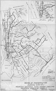
Since the opening of the original New York City Subway line in 1904, and throughout the subway's history, various official and planning agencies have proposed numerous extensions to the subway system. The first major expansion of the subway system was the Dual Contracts, a set of agreements between the City of New York and the IRT and the BRT. The system was expanded into the outer reaches of the Bronx, Brooklyn, and Queens, and it provided for the construction of important lines in Manhattan. This one expansion of the system provided for a majority of today's system.
Interstate 495 (I-495), commonly known as the Long Island Expressway (LIE), is an auxiliary Interstate Highway in the U.S. state of New York. It is jointly maintained by the New York State Department of Transportation (NYSDOT), the New York City Department of Transportation (NYCDOT), MTA Bridges and Tunnels (MTAB&T), and the Port Authority of New York and New Jersey (PANYNJ).
King's Highway 140, commonly referred to as Highway 140, is a provincially maintained highway in the Canadian province of Ontario. The highway connects Port Colborne near Lake Erie with Highway 406 in Welland, via the Main Street Tunnel. It was constructed in the early 1970s as part of the Welland Bypass project of the Welland Canal, which resulted in the severance of several highways and rail lines. Opened to traffic in late 1972, several months following the tunnel, Highway 140 has remained unchanged since, despite growing calls to resign it as an extension of Highway 406.

St Saviour is a parish of Jersey in the Channel Islands. It is located directly east of St Helier. It has a population of 13,580. It has a land surface area of 3.6 square miles and has a very small coastline at Le Dicq.

St Clement is one of the twelve parishes of Jersey in the Channel Islands. Its parish hall is around 3.6 kilometres (2.2 mi) south-east of St Helier. The parish has a population of 9,221 and is the second most densely populated.

St Martin is one of the twelve parishes of Jersey in the Channel Islands. It is 5.5 kilometres (3.4 mi) north-east of St Helier. It has a population of 3,763. The parish covers 10.3 km2 (4.0 sq mi).

St John is one of the twelve parishes of Jersey and is around 7.3 kilometres (4.5 mi) north of St Helier on the north coast of the island. It has a surface area of 8.7 km2. St John's Village is also the name of the main village in the parish.

Gorey is a village in the parishes of St Martin and Grouville on the east coast of Jersey. The harbour is one of the three main harbours of the island, and is located in St Martin. The main centre of the village is located at Gorey Pier near Mont Orgeuil Castle, a 13th century fortification, in St Martin, while there is a small community with a few shops. The church in the village is known as Gouray Church.
Transportation in New York is made up of some of the most extensive and one of the oldest transportation infrastructures in the country. Engineering difficulties because of the terrain of New York State and the unique issues of New York City brought on by urban crowding have had to be overcome since the state was young. Population expansion of the state generally followed the path of the early waterways, first the Hudson River and then the Erie Canal. Today, railroad lines and the New York State Thruway follow the same general route.

Hohlgangsanlage are a number of tunnels constructed in Jersey by occupying German forces during the occupation of Jersey. The Germans intended these bunkers to protect troops and equipment from aerial bombing and to act as fortifications in their own right.

The Staten Island Tunnel is an abandoned, incomplete railway/subway tunnel in New York City. It was intended to connect railways on Staten Island to the BMT Fourth Avenue Line of the New York City Subway, in Brooklyn, via a new crossing under the Narrows. Planned to extend 10,400 feet (3,200 m), the tunnel would have been among the world's longest at the time of its planning, in the late 19th and early 20th centuries.

Victoria Avenue is a major road in Jersey, connecting the capital St Helier to Bel Royal in St Lawrence, also providing access to the western part of the A1 for non-bus traffic, due to a bus gate that prevents traffic from the A1 continuing on the A1.

The A3 is a major road in Jersey connecting Saint Helier and Gorey, passing through Grouville and Longueville.
