
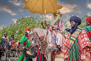
Nigeria’s transport network has expanded in recent years to accommodate a growing population. The transport and storage sector was valued at N2.6trn ($6.9bn) in current basic prices in 2020, down from N3trn ($8bn) in 2019, according to the National Bureau of Statistics (NBS). This was reflected in a lower contribution to GDP, at 1.8% in the fourth quarter of 2020, down from 2.1% during the same period the previous year but higher than the 0.8% recorded in the third quarter of 2020. One of the most significant challenges facing the sector is meeting the needs of both large coastal cities and rural inland communities in order to fully unlock the country’s economic potential. This is especially the case with mining and agriculture, both of which are expected to benefit from two large-scale projects: the Lekki Port in Lagos and the Kano-Maradi rail line in the north of the country.
Diffa is a city and Urban Commune in the extreme southeast of Niger, near the border with Nigeria. It is the administrative seat of both Diffa Region, and the smaller Diffa Department. As of 2011, the commune had a total population of 48,005 people.
Birni-N'Konni is a town in the Tahoua Region of Niger, lying immediately north of the border of Nigeria and west of seasonal Maggia River. It is an important market town and transport hub and as of the 2012 census had a population of 63,169. The town is the historic centre of the small pre-colonial Hausa state of Konni. The name comes from the Hausa for "Walled Town of Konni", and many Hausa towns designate the old citadel neighbourhood the "Birni".

Trans-Saharan trade is trade between sub-Saharan Africa and North Africa that requires travel across the Sahara. Though this trade began in prehistoric times, the peak of trade extended from the 8th century until the early 17th century CE. The Sahara once had a different climate and environment. In Libya and Algeria, from at least 7000 BCE, there were pastoralism, large settlements, and pottery. Cattle were introduced to the Central Sahara (Ahaggar) between 4000 to 3500 BCE. Remarkable rock paintings in arid regions portray flora and fauna that are not present in the modern desert.

Niger is a state in the North Central region of Nigeria and the largest state in the country by area. Niger state has three political zones, zone A, B and C. The state's capital is at Minna. Other major cities are Bida, Kontagora and Suleja. It was formed in 1976 when the then North-Western State was divided into Niger State and Sokoto State. It is home to Ibrahim Babangida and Abdulsalami Abubakar, two of Nigeria's former military rulers. The Nupe, Gbagyi, Kamuku, Kambari, Gungawa, Hun-Saare, Hausa and Koro form the majority of numerous indigenous tribes of Niger State.
Jigawa State is one of the 36 states of Nigeria, located in the northern region of the country. Created on 27 August 1991, under the General Ibrahim Babangida administration who announced the creation of nine additional states in the country bringing the total number of states then to thirty. The announcement was given a legal backing through the; State Creation and Transitional Provisions Decree No. 37 of 1991. Jigawa State was a part of Kano State and was located in the northeastern-most region of Kano State, and it forms part of Nigeria's national border with the Republic of Niger. The state capital and largest city is Dutse. Jigawa state has 27 local governments

Katsina State is a state in the northwestern geopolitical zone of Nigeria. Katsina State borders on the Republic of Niger to the north for 250 km and the States of Jigawa for 164 km and Kano to the east, Kaduna to the south for 161 km and Zamfara to the west. States. Nicknamed the "Home of Hospitality", both the state capital and the town of Daura have been described "ancient seats of Islamic culture and learning" in Nigeria.

Kebbi State is a state in northwestern Nigeria. Kebbi State is bordered east and north of Sokoto and Zamfara states, and to the south by Niger state while its western border forms part of the national borders with Benin Republic for 103 km and Niger for 207 km. Named for the city of Birnin Kebbi—the state's capital and largest city, Kebbi state was formed from Sokoto state on 27 August 1991. Of the 36 states of Nigeria, Kebbi is the tenth largest in area and 22nd most populous, with an estimated population of about 4.4 million as of 2016. The state is known as land of equity.

SokotoState is one of the 36 states of Nigeria, located in the extreme northwest of the country. Bounded by Republic of the Niger to the north and west for 363 km, and the states of Zamfara to the east, and Kebbi to the south and west, partly across the Ka River. Its capital and largest city is the city of Sokoto. Sokoto is located near to the confluence of the Sokoto River and the Rima River. As of 2005 it has an estimated population of more than 4.2 million.

The Trans–West African Coastal Highway or TAH 7 is a transnational highway project to link 12 West African coastal nations, from Mauritania in the north-west of the region to Nigeria in the east, with feeder roads already existing to two landlocked countries, Mali and Burkina Faso.
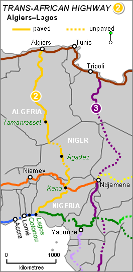
The Trans-Sahara Highway or TAH 2, also known as the African Unity Road, is a transnational highway project nearing completion to pave, improve and ease border formalities on an existing trade route running north–south across the Sahara Desert. It runs between North Africa bordered by the Mediterranean Sea in the north and West Africa bordered by the Atlantic Ocean in the south, from Algiers in Algeria to Lagos in Nigeria, giving it the alternative names of the Algiers–Lagos Highway or Lagos–Algiers Highway.

The Trans-Sahelian Highway or TAH 5 is a transnational highway project to pave, improve and ease border formalities on a highway route through the southern fringes of the Sahel region in West Africa between Dakar, Senegal in the west and Ndjamena, Chad, in the east. Alternative names for the highway are the Dakar-Ndjamena Highway or Ndjamena-Dakar Highway and it is Trans-African Highway 5 in the Trans-African Highway network.
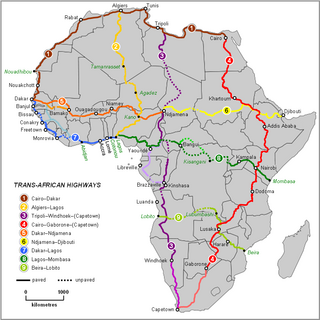
The Trans-African Highway network comprises transcontinental road projects in Africa being developed by the United Nations Economic Commission for Africa (UNECA), the African Development Bank (ADB), and the African Union in conjunction with regional international communities. They aim to promote trade and alleviate poverty in Africa through highway infrastructure development and the management of road-based trade corridors. The total length of the nine highways in the network is 56,683 km (35,221 mi).
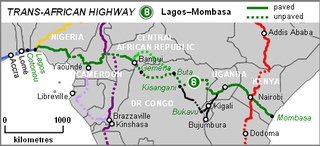
The Lagos–Mombasa Highway or TAH 8 is Trans-African Highway 8 and is the principal road route between West and East Africa. It has a length of 6,259 km (3,889 mi) and is contiguous with the Dakar-Lagos Highway with which it will form the longest east-west crossing of the continent for a total distance of 10,269 km (6,381 mi). Its main importance at the moment is connecting West Africa with Southern Africa via Yaoundé and Gabon because the section through the Democratic Republic of the Congo is unpaved and difficult.

Railway stations in Nigeria include:

The Cairo–Cape Town Highway is Trans-African Highway 4 in the transcontinental road network being developed by the United Nations Economic Commission for Africa (UNECA), the African Development Bank (AfDB), and the African Union. The route has a length of 10,228 km (6,355 mi) and links Cairo in Egypt to Cape Town in South Africa.
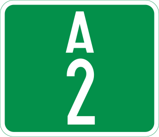
The A2 highway is a federal highway in Nigeria that spans 1,200 kilometres (750 mi). It serves as a vital transportation route, connecting the country's southern and northern regions.
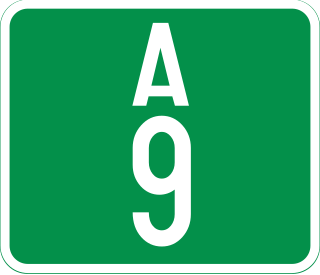
The A9 highway is a major highway in Nigeria, located in the northern region of the country. It serves as a vital transportation link, connecting several key cities and facilitating both domestic and international trade.
