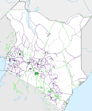
Transport in Kenya refers to the transportation structure in Kenya. The country has an extensive network of paved and unpaved roads.

Marsabit is a town in the northern Marsabit County in Kenya. It is situated in the former Eastern Province and is almost surrounded by the Marsabit National Park. The town is located 170 kilometres (110 mi) east of the centre of the East African Rift at an elevation of between 1300 and 1400 metres. It serves as the capital of Marsabit County, and lies southeast of the Chalbi Desert in a forested area known for its volcanoes and crater lakes and others.

Isiolo is a town in Isiolo County, of which it is the capital. It is located in the upper eastern region of Kenya and is geographically considered the center of the country Kenya. It lies 285 kilometers north of the capital Nairobi. The town grew around the local military camps, much of the population being Ameru community, Borana, and the descendants of former Somali soldiers who had fought in World War I. The town has an estimated population of 78,250, most of them living around the outskirts of the town. Like most African cities, there has been a steady increase in the urban population in recent years, especially moving from as far as Moyale, Marsabit and Mandera. Isiolo town is also becoming a centre of interest because of its newly acquired status as a resort city cashing in on the popular Samburu and Shaba Game reserves, which have become preferred destinations after the famed Maasai Mara. Isiolo lies along the long A2 Road, leading towards Marsabit and Moyale much further north.
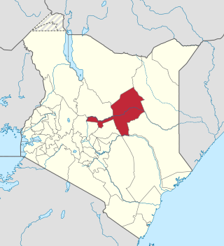
Marsabit County is a county in Kenya. Covering a surface area of 66,923.1 square kilometres. Marsabit is the second largest county by size in Kenya after Turkana county which has an area of 71,597.8 km2. Its capital is Marsabit and its largest town is Moyale. According to the 2019 census, the county has a population of 459,785. It is bordered to the North by Ethiopia, to the West by Turkana County to the South by Samburu County and Isiolo County, and to the East by Wajir County.
Isiolo County is a county in the former Eastern Province of Kenya. Its population is 268,002 and its capital and largest city is Isiolo. Isiolo County is to be the first county to be developed as part of the Kenya Vision 2030 program. Other upcoming urban centres are: Garbatulla, Modogashe, Kinna, Merti and Oldonyiro.The county is home to Sakuye and Borana tribes but also has a significant number of people from Turkana, Samburu, Gabra, Garre and Meru communities.
Habaswein is a town in Kenya's Wajir County, which is inhabited by Somalis. The Town, which is loved by many, is often referred to as "The Land Of Milk and Honey"
South Horr is a settlement in Kenya's former Rift Valley Province. It is located in Laisamis Constituency, of Marsabit County. The A4 Road from Maralal and Baragoi to Loyangalani passes through the village.
Premier Bank, formally First Community Bank (FCB), is a Shari'ah compliant commercial bank in Kenya, the largest economy in the East African Community. The bank received a formal approval from the Central Bank of Kenya in 2007, the national banking regulator in the country but commenced its official operations on 1 June 2008.
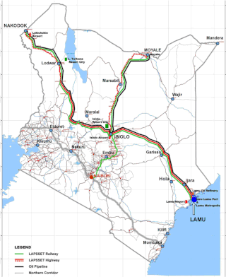
Lamu Port-South Sudan-Ethiopia-Transport (LAPSSET) Corridor project, also known as Lamu corridor is a transport and infrastructure project in Kenya that, when complete, will be the country's second transport corridor. Kenya's other transport corridor is the Northern Corridor, which links Mombasa to Uganda, passing through Nairobi and much of the Northern Rift. Some basic LAPSSET infrastructure has been built. The construction of LAPSSET's main components is currently ongoing with construction of the first berth at Lamu Port completed in October 2019.. Although the project is not formally stalled, its short to medium term success looks increasingly unlikely. Insecurity and political instability in Kenya are mostly to blame for this, as are more commercially viable alternative pipeline options through Tanzania or Ethiopia. The low oil prices since 2015 also affect LAPSSET's commercial prospects.

Sub-counties, also known as Districts, are the decentralised units through which government of Kenya provides functions and services. At national level, sub-counties take a more administrative function like security, statistical purposes, provision of government services, etc. Even though the sub-counties are divisions of counties, powers to create new national sub-counties lies with the national government. As of 2023, there are 314 sub-counties, compared to 290 constituencies. A deputy county commissioner is appointed by the state to lead each sub-county. The sub-counties are further divided into divisions, locations and sub-locations.

Ethiopia–Kenya relations are bilateral relations between Ethiopia and Kenya. The two nations maintain primarily trade ties.
The Kenya National Highways Authority (KeNHA) is an autonomous road agency. Its responsibility is for the management, development, rehabilitation, and maintenance of Class S, A and B roads as explained below.
Lamu–Garissa–Isiolo Road, is a road in Kenya, and is part of the Lamu-Garissa-Isiolo-Lokichar Road, which itself is a component of the Lamu Port and Lamu-Southern Sudan-Ethiopia Transport Corridor (LAPSSET) Project.
The Mombasa–Nairobi Expressway or Nairobi–Mombasa Expressway, also known as the Nairobi–Mombasa Highway, is a proposed four-lane toll highway in Kenya. The highway will link Nairobi, the capital and largest city of Kenya to Mombasa, the largest seaport of the country. The new highway is expected to cut travel times between the two cities from the current 6 to 10 hours to approximately four hours.
The Nairobi Southern Bypass Highway is a road in Kenya, forming a semi-circle through the south-western neighbourhoods of the capital city of Nairobi. The road allows traffic from Mombasa, destined for western Kenya and Uganda to bypass downtown Nairobi, thereby reducing traffic congestion in the city's central business district.

The Isiolo–Moyale Road is a road section of the A2 Road in Kenya, connecting the towns of Isiolo, Archers Post, Marsabit, and Moyale. The road is a component of the Lamu Port and Lamu-Southern Sudan-Ethiopia Transport Corridor (LAPSSET) Project. It connects Kenya to Ethiopia, its neighbor to the north.
Takaba is a town in Mandera County, in northeastern Kenya. According to the 2009 census, the town was the fourth most populous in the county with a population of 21,474. The town has a functional airstrip. The headquarters of Mandera West sub-county are located in Takaba.
Isiolo–Mandera Road, is a road in Kenya. It is a major transport route linking north-central Kenya to Kenya's northeast. The counties that the road traverses are generally arid, and have hitherto been undeserved. This road project is the largest and most expensive infrastructure project in northeastern Kenya since the country became independent in 1963.
Kung'u Ndung'u is a Kenyan civil engineer and business executive who was appointed as the Director-General of the Kenya National Highways Authority (KeNHA), effective 8 October 2021. He replaced Peter Mundinia who retired. Before his current assignment, Kung'u was the Director of Road Asset and Corridor Management at KeNHA.

