
Bridgetown is the capital and largest city of Barbados. Formerly The Town of Saint Michael, the Greater Bridgetown area is located within the parish of Saint Michael. Bridgetown is sometimes locally referred to as "The City", but the most common reference is simply "Town". As of 2014, its metropolitan population stands at roughly 110,000.

The M1 motorway connects London to Leeds, where it joins the A1(M) near Aberford, to connect to Newcastle. It was the first inter-urban motorway to be completed in the UK; the first motorway in the country was the Preston Bypass, which later became part of the M6.

The M2 is a 26-mile-long (42 km) long motorway in Kent, England, and was built to bypass a section of the A2 road in Kent, which goes through the Medway Towns, Sittingbourne, and Faversham. It provides an alternative route to the Port of Dover, which supplements the M20 motorway located further to the south. The terminal junctions of the M2 intersect with the A2, which come together to form a 62-mile-long (100 km) long trunk road from London to Dover.

The A68 is a major road in the United Kingdom, running from Darlington in England to the A720 in Edinburgh, the capital of Scotland. It crosses the Anglo-Scottish border at Carter Bar and is the only road to do so for some distance either way; the next major crossings are the A697 from Coldstream to Cornhill-on-Tweed in the east, and the A7 near Canonbie to the west.

The parish of St. Michael is one of eleven parishes of Barbados. It has a land area of 39 km2 (15 sq mi) and is found at the southwest portion of the island. Saint Michael has survived by name as one of the original six parishes created in 1629 by Governor Sir William Tufton.

The A350 is a north–south primary route in southern England, that runs from the M4 motorway in Wiltshire to Poole in Dorset.

The A500 is a major primary A road in Staffordshire and Cheshire, England. It is dual carriageway for most of its length and connects Nantwich, junctions 16 and 15 of the M6 motorway with the city of Stoke-on-Trent. It is 19 miles (31 km) long.

The parish of Christ Church is one of eleven historic political divisions of Barbados. It has a land area of 57 km2 (22 sq mi) and is found at the southern end of the island. Christ Church has survived by name as one of the original six parishes created in 1629 by Governor Sir William Tufton.

The parish of Saint James is an area located in the western central part of the country of Barbados. Increasingly St. James is becoming known as the playground of the rich and famous, and as a haven for sun-starved tourists with its up-market hotel resorts.

The landlocked parish of Saint Thomas is found in the centre of Barbados. It is one of only two landlocked parishes in the island, the other being Saint George to the south.

The A4540 is a ring road in Birmingham, England, also known as the Middle Ring Road, or the Middleway. It runs around the centre of the city at a distance of approximately 1 mile (1.6 km). The ring road was planned and designed by Herbert Manzoni. It is now simply known as the Ring Road due to the removal of the old Inner Ring Road.
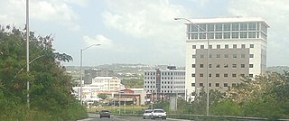
The City of Warrens, located in the parish of Saint Thomas, is one of the fastest developing areas in the country of Barbados. In the span of a few years beginning around the year 2000, the Warrens, Saint Thomas area has become synonymous with new money flowing into the country and for the development in the form of newly constructed tall buildings.
The Wildey area of the Parish of Saint Michael located roughly 4 km east of Bridgetown, it lies on the border with the Parish of Christ Church. Normally a very busy area with the ABC Highway, Wildey is one of the main convergence points for vehicles travelling either towards the capital-city Bridgetown or towards points in northern Barbados. In recent years the area was reconfigured for traffic mitigation, the tri-directional split or fork in the highway formerly known as the "Wildey Y" was changed to only allow southbound traffic to turn left or right on to Wildey Road only. Northbound traffic must now travel on Wildey Road to Highway R road which brings traffic back to BET hill.

The A380 is a road in South West England, connecting the Torbay area to the Devon Expressway, and hence to the rest of Great Britain's main road network.

The A585 is a primary road in England which runs from Kirkham to Fleetwood in Lancashire.

The A616 is a road that links Newark-on-Trent, Nottinghamshire, to the M1 motorway at Junction 30, then reappears at Junction 35A and goes on to Huddersfield, West Yorkshire.

The A6003 links Kettering and Corby in Northamptonshire, with Oakham in Rutland, via Leicestershire. The road forms the principal link between Rutland and Northamptonshire.
The City of Bridgetown constituency is one of eleven (11) electoral districts in the Parish of St. Michael, and one thirty (30) nationally in Barbados. The Constituency covers a portion of the capital city Bridgetown. The district formed in 1843 is the first electoral district formed after the original eleven in the country. The first representative for the constituency was the national hero the Right Excellent Samuel Jackman Prescod. The member of parliament since 2022 is Corey Lane from the Barbados Labour Party. Before then it was held by Lt.Col. Jeffrey Bostic (Ret.) from 2013. The seat is usually won by a slim margin.

