Related Research Articles

Humboldt County is a county located in the U.S. state of California. As of the 2020 census, the population was 136,463. The county seat is Eureka.

Kings County is a county located in the U.S. state of California. The population was 152,486 at the 2020 census. The county seat is Hanford.

Mendocino County is a county located on the North Coast of the U.S. state of California. As of the 2020 census, the population was 91,601. The county seat is Ukiah.

Pineville is a suburban town in the southernmost portion of Mecklenburg County, North Carolina, United States. Part of the Charlotte metropolitan area, it is situated in the Waxhaws district between Charlotte and Fort Mill.

The Amana Colonies are seven villages on 26,000 acres (110 km2) located in Iowa County in east-central Iowa, United States: Amana, East Amana, High Amana, Middle Amana, South Amana, West Amana, and Homestead. The villages were built and settled by German Radical Pietists, who were persecuted in their homeland by the German state government and the Lutheran Church. Calling themselves the True Inspiration Congregations, they first settled in New York near Buffalo in what is now the town of West Seneca. However, seeking more isolated surroundings, they moved to Iowa in 1856. They lived a communal life until 1932.
The Big Pine Band of Owens Valley Paiute Shoshone Indians of the Big Pine Reservation are a federally recognized tribe of Mono and Timbisha Indians in California.
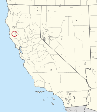
The Redwood Valley Rancheria is a federally recognized Indian tribe located in Redwood Valley, Mendocino County, California. The tribe is primarily composed of Pomo Indians. Redwood Valley Rancheria is a sovereign Indian tribe with the powers of self-governance.

The Joplin, Missouri, Metropolitan Statistical Area (MSA), as defined by the United States Census Bureau, is an area consisting of Jasper and Newton counties in southwest Missouri, anchored by the city of Joplin. The estimated 2020 population of the Joplin, MO (MSA) is 181,460.
The Big Lagoon Rancheria is a federally recognized tribe of Yurok and Tolowa Indians. They are located in Humboldt County, California, and their tribal headquarters is in Arcata, California.
The Big Sandy Rancheria of Mono Indians of California is a ranchería and federally recognized tribe of Western Mono Indians (Monache) located in Fresno County, California, United States. As of the 2010 Census the population was 118. In 1909, the Bureau of Indian Affairs (BIA) bought 280 acres of land for the Big Sandy Band of Western Mono Indians.
The Blue Lake Rancheria of the Wiyot, Yurok, and Hupa Indians is located northwest of the city of Blue Lake in Humboldt County, California on approximately 76 acres (0.31 km2). As of 2007, there were 53 enrolled members. As of the 2010 Census the population of Blue Lake Rancheria was 58.

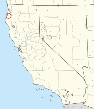
The Elk Valley Rancheria is a ranchería and federally recognized tribe of Tolowa and Yurok people. It is located in the census-designated place of Bertsch-Oceanview, Del Norte County, California, just east of Crescent City. As of the 2010 Census, the population was 99.

The Augusta metropolitan area is a metropolitan area in the U.S. states of Georgia and South Carolina centered on the principal city of Augusta. The U.S. Office of Management and Budget, Census Bureau and other agencies define Augusta's Metropolitan Statistical Area, the Augusta-Richmond County, GA-SC Metropolitan Statistical Area, as comprising Richmond, Burke, Columbia, Lincoln, and McDuffie counties in Georgia and Aiken and Edgefield counties in South Carolina. The official 2021 U.S. Census estimate for the area was 615,963 residents.

The Bear River Band of the Rohnerville Rancheria is a federally recognized tribe of Mattole, Bear River and Wiyot people in Humboldt County, California.

The Kletsel Dehe Wintun Nation of the Cortina Rancheria is a federally recognized tribe of Indigenous people of California. They are Wintun people, who historically spoke Wintuan languages.
The Bishop Paiute Tribe, formerly known as the Paiute-Shoshone Indians of the Bishop Community of the Bishop Colony is a federally recognized tribe of Mono and Timbisha Indians of the Owens Valley, in Inyo County of eastern California. As of the 2010 Census the population was 1,588.
The Grindstone Indian Rancheria of Wintun-Wailaki Indians is a federally recognized tribe and ranchería of Wintun and Wailaki Indians from northern California. As of the 2010 Census the population was 164.
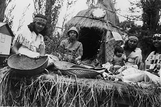
The Cher-Ae Heights Indian Community of the Trinidad Rancheria is a federally recognized tribe with members who are descendants of Chetco, Hupa, Karuk, Tolowa, Wiyot, and Yurok people in Humboldt County, California. As of the 2010 Census the population was 132.
Collinsburg is a census-designated place located in Rostraver Township, Westmoreland County in the state of Pennsylvania, United States. As of the 2010 census the population was 1,125 residents.
References
- ↑ "Intergovernmental Affairs: Tribal Affairs — American Indian and Alaska Native (AIAN)".
- ↑ [ dead link ]
- ↑ [ dead link ]
- ↑ [ dead link ]
- ↑ [ dead link ]
- ↑ [ dead link ]
- ↑ [ dead link ]
- ↑ [ dead link ]
- ↑ [ dead link ]
- ↑ [ dead link ]
- ↑ "Archived copy". Archived from the original on 2017-02-07. Retrieved 2017-12-11.
{{cite web}}: CS1 maint: archived copy as title (link) - ↑ "2010 Census Interactive Population Search". Archived from the original on 2017-01-18. Retrieved 2017-12-11.
- ↑ https://www.census.gov/2010census/popmap/ipmtext.php?fl=0125%5B%5D
- ↑ "2010 Census: Interactive Population Map - U.S. Census Bureau". Archived from the original on 2018-07-19. Retrieved 2017-12-11.
- ↑ "2010 Census Interactive Population Search". Archived from the original on 2017-02-06. Retrieved 2017-12-11.
- ↑ [ dead link ]
- ↑ https://www.census.gov/2010census/popmap/ipmtext.php?fl=0240%5B%5D
- ↑ https://www.census.gov/2010census/popmap/ipmtext.php?fl=0250%5B%5D
- ↑ https://www.census.gov/2010census/popmap/ipmtext.php?fl=0265%5B%5D
- ↑ https://www.census.gov/2010census/popmap/ipmtext.php?fl=0290%5B%5D
- ↑ https://www.census.gov/2010census/popmap/ipmtext.php?fl=0325%5B%5D
- ↑ "2010 Census Interactive Population Search". Archived from the original on 2017-02-06. Retrieved 2017-12-11.
- ↑ "2010 Census Interactive Population Search". Archived from the original on 2017-01-18. Retrieved 2017-12-11.
- ↑ "2010 Census Interactive Population Search". Archived from the original on 2017-01-18. Retrieved 2017-12-11.
- ↑ "2010 Census: Interactive Population Map - U.S. Census Bureau". Archived from the original on 2018-07-19. Retrieved 2017-12-11.
- ↑ [ dead link ]
- ↑ [ dead link ]
- ↑ [ dead link ]
- ↑ [ dead link ]
- ↑ https://www.census.gov/2010census/popmap/ipmtext.php?fl=0720%5B%5D
- ↑ https://www.census.gov/2010census/popmap/ipmtext.php?fl=0735%5B%5D
- ↑ https://www.census.gov/2010census/popmap/ipmtext.php?fl=0750%5B%5D
- ↑ https://www.census.gov/2010census/popmap/ipmtext.php?fl=0780%5B%5D
- ↑ [ dead link ]
- ↑ [ dead link ]
- ↑ https://www.census.gov/2010census/popmap/ipmtext.php?fl=1010%5B%5D
- ↑ "2010 Census Interactive Population Search". Archived from the original on 2018-04-30. Retrieved 2017-12-11.
- ↑ [ dead link ]
- ↑ [ dead link ]
- ↑ https://www.census.gov/2010census/popmap/ipmtext.php?fl=1195%5B%5D
- ↑ [ dead link ]
- ↑ https://www.census.gov/2010census/popmap/ipmtext.php?fl=1280%5B%5D
- ↑ "Archived copy". Archived from the original on 2017-02-05. Retrieved 2017-12-11.
{{cite web}}: CS1 maint: archived copy as title (link) - ↑ "Archived copy". Archived from the original on 2017-01-17. Retrieved 2017-12-11.
{{cite web}}: CS1 maint: archived copy as title (link) - ↑ [ dead link ]
- ↑ https://www.census.gov/2010census/popmap/ipmtext.php?fl=1490%5B%5D
- ↑ [ dead link ]
- ↑ "2010 Census Interactive Population Search". Archived from the original on 2016-12-28. Retrieved 2017-12-11.
- ↑ [ dead link ]
- ↑ [ dead link ]
- ↑ https://www.census.gov/2010census/popmap/ipmtext.php?fl=1750%5B%5D
- ↑ [ dead link ]
- ↑ "2010 Census: Interactive Population Map - U.S. Census Bureau". Archived from the original on 2018-07-19. Retrieved 2017-12-11.
- ↑ "2010 Census: Interactive Population Map - U.S. Census Bureau". Archived from the original on 2018-07-19. Retrieved 2017-12-11.
- ↑ [ dead link ]
- ↑ "2010 Census Interactive Population Search". Archived from the original on 2017-02-07. Retrieved 2017-12-11.
- ↑ "2010 Census: Interactive Population Map - U.S. Census Bureau". Archived from the original on 2018-07-19. Retrieved 2017-12-11.
- ↑ [ dead link ]
- ↑ [ dead link ]
- ↑ "2010 Census: Interactive Population Map - U.S. Census Bureau". Archived from the original on 2018-07-19. Retrieved 2017-12-11.
- ↑ "2010 Census: Interactive Population Map - U.S. Census Bureau". Archived from the original on 2018-07-19. Retrieved 2017-12-11.
- ↑ [ dead link ]
- ↑ "2010 Census Interactive Population Search". Archived from the original on 2017-01-18. Retrieved 2017-12-11.
- ↑ "Archived copy". Archived from the original on 2017-02-05. Retrieved 2017-12-11.
{{cite web}}: CS1 maint: archived copy as title (link) - ↑ "2010 Census: Interactive Population Map - U.S. Census Bureau". Archived from the original on 2018-07-19. Retrieved 2017-12-11.
- ↑ [ dead link ]
- ↑ "2010 Census: Interactive Population Map - U.S. Census Bureau". Archived from the original on 2018-07-19. Retrieved 2017-12-11.
- ↑ "2010 Census Interactive Population Search". Archived from the original on 2017-01-18. Retrieved 2017-12-11.
- ↑ "Archived copy". Archived from the original on 2017-02-05. Retrieved 2017-12-11.
{{cite web}}: CS1 maint: archived copy as title (link) - ↑ [ dead link ]
- ↑ "Archived copy". Archived from the original on 2017-02-13. Retrieved 2017-12-11.
{{cite web}}: CS1 maint: archived copy as title (link) - ↑ [ dead link ]
- ↑ [ dead link ]
- ↑ https://www.census.gov/2010census/popmap/ipmtext.php?fl=3145%5B%5D
- ↑ "2010 Census: Interactive Population Map - U.S. Census Bureau". Archived from the original on 2018-07-19. Retrieved 2017-12-11.
- ↑ [ dead link ]
- ↑ https://www.census.gov/2010census/popmap/ipmtext.php?fl=3220%5B%5D
- ↑ "2010 Census Interactive Population Search". Archived from the original on 2017-01-18. Retrieved 2017-12-11.
- ↑ "Archived copy". Archived from the original on 2018-08-29. Retrieved 2017-12-11.
{{cite web}}: CS1 maint: archived copy as title (link) - ↑ [ dead link ]
- ↑ [ dead link ]
- ↑ "2010 Census: Interactive Population Map - U.S. Census Bureau". Archived from the original on 2018-07-19. Retrieved 2017-12-11.
- ↑ https://www.census.gov/2010census/popmap/ipmtext.php?fl=3520%5B%5D
- ↑ https://www.census.gov/2010census/popmap/ipmtext.php?fl=3525%5B%5D
- ↑ [ dead link ]
- ↑ "2010 Census: Interactive Population Map - U.S. Census Bureau". Archived from the original on 2018-07-19. Retrieved 2017-12-11.
- ↑ [ dead link ]
- ↑ https://www.census.gov/2010census/popmap/ipmtext.php?fl=3750%5B%5D
- ↑ "2010 Census Interactive Population Search". Archived from the original on 2017-01-18. Retrieved 2017-12-11.
- ↑ https://www.census.gov/2010census/popmap/ipmtext.php?fl=3855%5B%5D
- ↑ "2010 Census Interactive Population Search". Archived from the original on 2017-02-13. Retrieved 2017-12-11.
- ↑ [ dead link ]
- ↑ "2010 Census: Interactive Population Map - U.S. Census Bureau". Archived from the original on 2018-07-19. Retrieved 2017-12-11.
- ↑ https://www.census.gov/2010census/popmap/ipmtext.php?fl=4095%5B%5D
- ↑ [ dead link ]
- ↑ "2010 Census Interactive Population Search". Archived from the original on 2017-01-18. Retrieved 2017-12-11.
- ↑ https://www.census.gov/2010census/popmap/ipmtext.php?fl=4275%5B%5D
- ↑ [ dead link ]
- ↑ [ dead link ]
- ↑ https://www.census.gov/2010census/popmap/ipmtext.php?fl=4375%5B%5D
- ↑ "2010 Census: Interactive Population Map - U.S. Census Bureau". Archived from the original on 2018-07-19. Retrieved 2017-12-11.
- ↑ https://www.census.gov/2010census/popmap/ipmtext.php?fl=4665%5B%5D
- ↑ [ dead link ]
- ↑ https://www.census.gov/2010census/popmap/ipmtext.php?fl=4760%5B%5D
- ↑ [ dead link ]