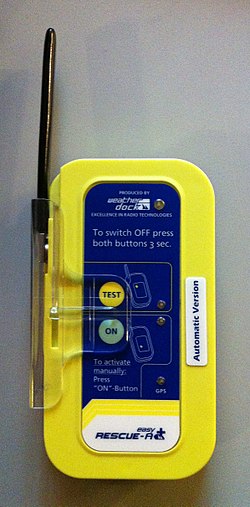
AIS-SART

Last updated
AIS S.A.R.T. EasyRescue-AA AIS-Klasse-B S.A.R.T., Water Activation.JPG
AIS S.A.R.T.

The AIS-SART is a self-contained radio device used to locate a survival craft or distressed vessel by sending updated position reports using a standard Automatic Identification System (AIS) class-A position report. The position and time synchronization of the AIS-SART are derived from a built in GNSS receiver (e.g. GPS). [1] Shipboard Global Maritime Distress Safety System (GMDSS) installations include one or more search and rescue locating devices. These devices may be either an AIS-SART (AIS Search and Rescue Transmitter) (from January 1, 2010), or a radar-SART (Search and Rescue Transponder).

The AIS-SART derives position and time synchronization from a built in GNSS receiver. Once per minute, the position is sent as a series of eight identical position report messages (four on 161.975 MHz and four on 162.025 MHz). This scheme creates a high probability that at least one of the messages is sent on the highest point of a wave.

AIS SARTs are typically cylindrical and brightly colored. A typical model is 251mm (about 10 inches) high and weighs 450g (about a pound). [2]

The specification (IEC 61097-14 Ed 1.0) for AIS-SART was developed by the IEC's TC80 AIS work group. AIS-SART was added to the GMDSS regulations effective January 1, 2010. [3]

See also

Related Research Articles

<span class="mw-page-title-main">Emergency position-indicating radiobeacon</span> Distress radio beacon, a tracking transmitter that is triggered during an accident

An emergency position-indicating radiobeacon (EPIRB) is a type of emergency locator beacon for commercial and recreational boats, a portable, battery-powered radio transmitter used in emergencies to locate boaters in distress and in need of immediate rescue. In the event of an emergency, such as a ship sinking or medical emergency onboard, the transmitter is activated and begins transmitting a continuous 406 MHz distress radio signal, which is used by search-and-rescue teams to quickly locate the emergency and render aid. The signal is detected by satellites operated by an international consortium of rescue services, COSPAS-SARSAT, which can detect emergency beacons anywhere on Earth transmitting on the distress frequency of 406 MHz. The satellites calculate the position or utilize the GPS coordinates of the beacon and quickly passes the information to the appropriate local first responder organization, which performs the search and rescue. As Search and Rescue approach the search areas, they use Direction Finding (DF) equipment to locate the beacon using the 121.5 MHz homing signal, or in newer EPIRBs, the AIS location signal. The basic purpose of this system is to help rescuers find survivors within the so-called "golden day" during which the majority of survivors can usually be saved. The feature distinguishing a modern EPIRB, often called GPIRB, from other types of emergency beacon is that it contains a GPS receiver and broadcasts its position, usually accurate within 100 m (330 ft), to facilitate location. Previous emergency beacons without a GPS can only be localized to within 2 km (1.2 mi) by the COSPAS satellites and relied heavily upon the 121.5 MHz homing signal to pin-point the beacons location as they arrived on scene.

<span style="text-decoration:overline;">SOS</span> International Morse code distress signal

SOS is a Morse code distress signal, used internationally, that was originally established for maritime use. In formal notation SOS is written with an overscore line, to indicate that the Morse code equivalents for the individual letters of "SOS" are transmitted as an unbroken sequence of three dots / three dashes / three dots, with no spaces between the letters. In International Morse Code three dots form the letter "S" and three dashes make the letter "O", so "S O S" became a common way to remember the order of the dots and dashes.

A distress signal, also known as a distress call, is an internationally recognized means for obtaining help. Distress signals are communicated by transmitting radio signals, displaying a visually observable item or illumination, or making a sound audible from a distance.

<span class="mw-page-title-main">Marine VHF radio</span> Radios operating in the very high frequency maritime mobile band

Marine VHF radio is a worldwide system of two way radio transceivers on ships and watercraft used for bidirectional voice communication from ship-to-ship, ship-to-shore, and in certain circumstances ship-to-aircraft. It uses FM channels in the very high frequency (VHF) radio band in the frequency range between 156 and 174 MHz, inclusive, designated by the International Telecommunication Union as the VHF maritime mobile band. In some countries additional channels are used, such as the L and F channels for leisure and fishing vessels in the Nordic countries. Transmitter power is limited to 25 watts, giving them a range of about 100 kilometres.

The Global Maritime Distress and Safety System (GMDSS) is a worldwide system for automated emergency signal communication for ships at sea developed by the United Nations' International Maritime Organization (IMO) as part of the SOLAS Convention.

<span class="mw-page-title-main">Digital selective calling</span>

Digital selective calling or DSC is a standard for transmitting predefined digital messages via the medium-frequency (MF), high-frequency (HF) and very-high-frequency (VHF) maritime radio systems. It is a core part of the Global Maritime Distress Safety System (GMDSS).

A Maritime Mobile Service Identity (MMSI) is effectively a maritime object's international maritime telephone number, a temporarily assigned UID, issued by that object's current flag state.

<span class="mw-page-title-main">Radar beacon</span> Transmitter-receiver associated with a fixed navigational mark

Radar beacon is – according to article 1.103 of the International Telecommunication Union's (ITU) ITU Radio Regulations (RR) – defined as "A transmitter-receiver associated with a fixed navigational mark which, when triggered by a radar, automatically returns a distinctive signal which can appear on the display of the triggering radar, providing range, bearing and identification information." Each station shall be classified by the service in which it operates permanently or temporarily.

<span class="mw-page-title-main">Search and rescue transponder</span>

A search and rescue transponder (SART) is a self-contained, waterproof transponder intended for emergency use at sea. These devices may be either a radar-SART, or a GPS-based AIS-SART.

<span class="mw-page-title-main">Automatic identification system</span> Automatic tracking system that uses transceivers on ships

The automatic identification system (AIS) is an automatic tracking system that uses transceivers on ships and is used by vessel traffic services (VTS). When satellites are used to receive AIS signatures, the term Satellite-AIS (S-AIS) is used. AIS information supplements marine radar, which continues to be the primary method of collision avoidance for water transport. Although technically and operationally distinct, the ADS-B system is analogous to AIS and performs a similar function for aircraft.

A second mate or second officer (2/O) is a licensed member of the deck department of a merchant ship holding a Second Mates Certificate of Competency, which is issued by the administration. The second mate is the third in command and a watchkeeping officer, customarily the ship's navigator. Other duties vary, but the second mate is often the medical officer and in charge of maintaining distress signaling equipment. On oil tankers, the second mate usually assists the chief mate with the cargo operations.

<span class="mw-page-title-main">Inmarsat-C</span>

Inmarsat-C is a two-way, packet data service operated by the telecommunications company Inmarsat which operates between mobile earth stations (MES) and land earth stations (LES). It became fully operational after a period of pre-operational trials in January 1991. The advantages of Inmarsat-C compared to Inmarsat-A are low cost, smaller and uses a smaller omni-directional antenna. The disadvantage is that voice communication is not possible with Inmarsat-C. The service is approved for use under the Global Maritime Distress and Safety System (GMDSS), meets the requirements for Ship Security Alert Systems (SSAS) defined by the International Maritime Organization (IMO) and is the most widely used service in fishing Vessel Monitoring Systems (VMS).

<span class="mw-page-title-main">International Cospas-Sarsat Programme</span> International satellite-aided search and rescue initiative

The International Cospas-Sarsat Programme is a satellite-aided search and rescue (SAR) initiative. It is organized as a treaty-based, nonprofit, intergovernmental, humanitarian cooperative of 45 nations and agencies. It is dedicated to detecting and locating emergency locator radio beacons activated by persons, aircraft or vessels in distress, and forwarding this alert information to authorities that can take action for rescue. Member countries operate a constellation of around 66 satellites orbiting the Earth which carry radio receivers capable of locating an emergency beacon anywhere on Earth transmitting on the Cospas-Sarsat frequency of 406 MHz.

<span class="mw-page-title-main">2182 kHz</span> Radio distress frequency

The radio frequency 2182 kHz is one of the international calling and distress frequencies for maritime radiocommunication in a frequency band allocated to the mobile service on first priority ("primary") basis, exclusively for distress and calling operations.

Global Navigation Satellite System (GNSS) receivers, using the GPS, GLONASS, Galileo or BeiDou system, are used in many applications. The first systems were developed in the 20th century, mainly to help military personnel find their way, but location awareness soon found many civilian applications.

An international distress frequency is a radio frequency that is designated for emergency communication by international agreement.

<span class="mw-page-title-main">Survival radio</span> Small radios carried to facilitate rescue in an emergency

Survival radios are carried by ships and aircraft to facilitate rescue in an emergency. They are generally designed to transmit on international distress frequencies. Maritime systems have been standardized under the Global Maritime Distress Safety System.

A Satellite Emergency Notification Device or SEND is a portable emergency notification and locating device which uses commercial satellite systems rather than the COSPAS-SARSAT satellite system. An example of this device is SPOT.

APRS Calling is a manual procedure for calling stations on the Automatic Packet Reporting System (APRS) to initiate communications on another frequency, or possibly by other means. It is inspired by Digital Selective Calling, a part of the Global Maritime Distress Safety System. It also builds on existing digital procedures inherited from morse code and radioteletype operation. ITU Q codes are used in conjunction with APRS text messages to implement APRS calling. APRS calling is intended to complement monitoring voice calling frequencies.

An emergency locator beacon is a radio beacon, a portable battery powered radio transmitter, used to locate airplanes, vessels, and persons in distress and in need of immediate rescue. Various types of emergency locator beacons are carried by aircraft, ships, vehicles, hikers and cross-country skiers. In case of an emergency, such as the aircraft crashing, the ship sinking, or a hiker becoming lost, the transmitter is deployed and begins to transmit a continuous radio signal, which is used by search and rescue teams to quickly find the emergency and render aid. The purpose of all emergency locator beacons is to help rescuers find survivors within the so-called "golden day", the first 24 hours following a traumatic event, during which the majority of survivors can usually be saved.

References

  1. Robert Connolly (June 2010). "A new AIS SART, Coastwatch and Irish airshows". Radio User. 5 (6): 40–41. ISSN   1748-8117.
  2. "SART / AIS-SART". JOTRON. Retrieved 2012-04-27.
  3. IEC Technical Committee 80. "Maritime Navigation and Radiocommunication Equipment and Systems" (PDF). IEC. Archived from the original (PDF) on 2012-10-03. Retrieved 2012-04-25.