Abalessa

Last updated
Abalessa
أبلسة
Town and commune
DZ-11 Abalessa.svg
Location of Abalessa commune within Tamanrasset Province
Algeria location map.svg
Red pog.svg
Abalessa
Location of Abalessa within Algeria
Coordinates: 22°53′24″N4°50′50″E / 22.89000°N 4.84722°E / 22.89000; 4.84722 Coordinates: 22°53′24″N4°50′50″E / 22.89000°N 4.84722°E / 22.89000; 4.84722
Country Flag of Algeria.svg  Algeria
Province Tamanrasset
District Abalessa (coextensive)
Government
   PMA Seats 7
Area
  Total74,563 km2 (28,789 sq mi)
Elevation
909 m (2,982 ft)
Population
 (2008) [1]
  Total9,163
  Density0.12/km2 (0.32/sq mi)
Time zone UTC+01 (CET)
Postal code
11120
ONS code1102

Abalessa is a town and commune in Tamanrasset Province, in southern Algeria, coextensive with the district of the same name. According to the 2008 census it has a population of 9,163 [1] up from 6,484 in 1998, [2] with an annual growth rate of 3.6%. [1] Abalessa is located along the ancient Trans-Saharan trade route, 80 kilometres (50 mi) west of the city of Tamanrasset, the capital of the province. The postcode of the town is 11120.

Contents

History

The former capital of the Ahaggar, Abalessa is famous for the Tin Hinan Tomb. This 1,500 year old monumental grave is dedicated to the Tuareg matriarch Tin Hinan, and vestiges of a Tifinagh inscription have been found on one of its walls. [3] According to Henri Lhote, the edifice may have built on top of an earlier Roman castrum since its architecture is different from the surrounding tombs and similar to that used by the Roman legionaries to construct their desert fortifications. [4]

On 18 October 1927, Byron Khun de Prorok discovered a vault near Abalessa containing a skeleton, belonging to a woman, and her furniture. In his book Mysterious Sahara: The Land of Gold, of Sand, and of Ruin Khun de Prorok attributed the skeleton to Tin Hinan. Today, the skeleton is on display at the Bardo Museum in Algiers, while the monument where it was discovered continues to be a popular tourist attraction in Abalessa among visitors to the Tamanrasset.[ citation needed ]

Geography

The municipality reaches an average elevation of approximately 909 metres (2,982 ft) above sea level. The main town lies at an elevation of 893 metres (2,930 ft), at the confluence of the two intermittent wadis Oued Rellachene and Oued Iheri. [5] A rocky mountain range, part of the Ahaggar Mountains rises to the west of the town reaching about 1,200 metres (3,900 ft). There is significant vegetation in the river valleys; the area belongs to the West Saharan montane xeric woodlands ecoregion.

Transportation

The N55A national highway, which branches off from the Trans-Sahara Highway (route N1) at Tit, is the main road through the area, passing just south of Abalessa.

Education

4.6% of the population has a tertiary education, and another 12.4% has completed secondary education. [6] The overall literacy rate is 78.7%, and is 85.4% among males and 70.8% among females. [7]

Localities

The commune is composed of eight localities: [8]

Related Research Articles

<span class="mw-page-title-main">Guemar</span> Commune and town in El Oued Province, Algeria

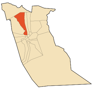
Guemar is a Saharan oasis town in Algeria near the Tunisian border, in the Oued Souf area of the El Oued Province, about 20 km north of El Oued. It includes a zaouia and a border post. According to the 2008 census it has a population of 39,168, up from 29,185 in 1998, with an annual growth rate of 3.0%.

<span class="mw-page-title-main">El Oued</span> City in El Oued Province, Algeria

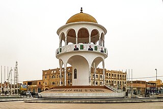
El Oued, Souf or Oued Souf is a city, and the capital of El Oued Province, in Algeria. The oasis town is watered by an underground river, hence its name is El Oued which enables date palm cultivation and the rare use of brick construction for housing. As most roofs are domed, it is known as the "City of a Thousand Domes".

<span class="mw-page-title-main">In Guezzam</span> Town and commune in Algeria

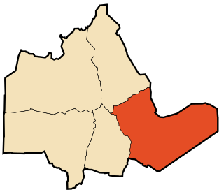
In Guezzam is a town and commune that is the capital of In Guezzam Province, Algeria, on the border with Niger. Till 26 November 2019 it was part of the Tamanrasset Province. The border town on the Niger side is Assamaka. According to the 2008 census it has a population of 7,045, up from 4,938 in 1998, with an annual growth rate of 3.7%, the second highest in the Tamanrasset province's 2008 boundaries.

<span class="mw-page-title-main">El Menia</span> Commune and town in Ghardaïa Province, Algeria

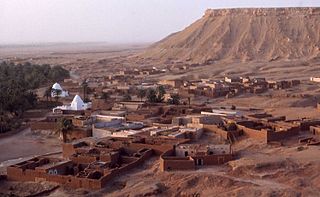
El Menia is an oasis town and commune, and capital of El Ménia District, in Ghardaïa Province, Algeria. The former name is El Goléa ; together in Arabic, the two names mean Impregnable Castle. According to the 2008 census it has a population of 40,195, up from 28,848 in 1998, with an annual growth rate of 3.4%. The area is inhabited by the Zenete Berbers. El Menia oasis grows many agricultural products. The grave of the French priest Charles de Foucauld is located in the town.

<span class="mw-page-title-main">Tamanrasset</span> City in Tamanrasset Province, Algeria

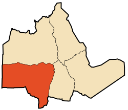
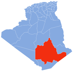
Tamanrasset, also known as Tamanghasset or Tamenghest, is an oasis city and capital of Tamanrasset Province in southern Algeria, in the Ahaggar Mountains. It is the chief city of the Algerian Tuareg. It is located an altitude of 1,320 metres (4,330 ft). As of the 2008 census, it has a population of 92,635, up from 72,741 in 1998, with an annual growth rate of 2.5%.

<span class="mw-page-title-main">Tin Zaouatine</span> Town and commune in In Guezzam, Algeria

Tin Zaouatine is a commune, coextensive with the district of Tin Zaouatine, in In Guezzam Province, Algeria. According to the 2008 census it has a population of 4,157, up from 2,314 in 1998, with an annual growth rate of 6.2%, the highest rate in the province. Its postal code is 11150 and its municipal code is 1107.

<span class="mw-page-title-main">Foggaret Ezzaouia</span> Commune and town in In Salah Province, Algeria

Foggaret Ezzoua is a municipality in In Salah District, In Salah Province, Algeria. According to the 2008 census it has a population of 6,649, up from 4,763 in 1998, with an annual growth rate of 3.5%. Its postal code is 11220 and its municipal code is 1110.

<span class="mw-page-title-main">Tazrouk</span> Commune and town in Tamanrasset, Algeria

Tazrouk is a town and commune, and district seat of Tazrouk District in Tamanrasset Province, Algeria. According to the 2008 census it has a population of 4,208, up from 3,033 in 1998, with an annual growth rate of 3.1%. Its postal code is 11140 and its municipal code is 1106.

<span class="mw-page-title-main">Idlès</span> Municipality in Tamanrasset Province, Algeria

Idlès is a municipality in Tazrouk District, Tamanrasset Province, Algeria. According to the 2008 census it has a population of 4,945, up from 3,791 in 1998, with an annual growth rate of 2.7%. Its postal code is 11110 and its municipal code is 1105. The largest nearby city is Tamanrasset; other smaller towns include In Amguel to the west and Tazrouk to the south.

<span class="mw-page-title-main">Sebseb</span> Commune and town in Ghardaïa, Algeria

Sebseb is a town and commune in Métlili District, Ghardaïa Province, Algeria. According to the 2008 census it has a population of 2,437, up from 2,428 in 1998, with an annual growth rate of 0.0%, the lowest in the province. Its postal code is 47230 and its municipal code is 4709.

<span class="mw-page-title-main">Bounoura</span> Commune and town in Ghardaïa Province, Algeria

Bounoura is a town and commune and capital of Bounoura District in Ghardaïa Province, Algeria. According to the 2008 census it has a population of 35,405, up from 27,775 in 1998, with an annual growth rate of 2.5%. It is effectively a suburb of the provincial capital Ghardaïa.

<span class="mw-page-title-main">Taghzout, El Oued</span> Commune and town in El Oued Province, Algeria

Taghzout is a town and commune in Guemar District, El Oued Province, Algeria. According to the 2008 census it has a population of 13,934, up from 11,147 in 1998, with an annual growth rate of 2.3%. Taghzout is adjacent to the town of Guemar, and is 13 kilometres (8.1 mi) from the provincial capital, El Oued.

<span class="mw-page-title-main">Zelfana</span> Commune and town in Ghardaïa Province, Algeria

Zelfana is a town and commune, coextensive with Zelfana District, in Ghardaïa Province, Algeria. According to the 2008 census it has a population of 10,161, up from 7,241 in 1998, with an annual growth rate of 3.5%.

<span class="mw-page-title-main">Hassani Abdelkrim</span> Place in El Oued Province, Algeria

Hassani Abdelkrim is a town and commune in Debila District, El Oued Province, Algeria. According to the 2008 census it has a population of 22,755, up from 17,207 in 1998, with a population growth rate of 2.9%.

<span class="mw-page-title-main">Hassi Khelifa</span> Commune and town in El Oued Province, Algeria

Hassi Khelifa is a town and commune, and capital of Hassi Khelifa District in El Oued Province, Algeria. According to the 2008 census it has a population of 31,784, up from 25,118 in 1998, with an annual growth rate of 2.4%.

<span class="mw-page-title-main">Sidi Aoun</span> Commune and town in El Oued Province, Algeria

Sidi Aoun is a town and commune in Magrane District, El Oued Province, Algeria. According to the 2008 census it has a population of 12,235, up from 10,018 in 1998, and an annual growth rate of 2.1%. Sidi Aoun is connected by local roads to Hassani Abdelkrim and Debila, two towns just north-east of El Oued.

<span class="mw-page-title-main">Hassi Fehal</span> Commune and town in Ghardaïa Province, Algeria

Hassi Fehal is a town and commune in Mansoura District, Ghardaïa Province, Algeria. According to the 2008 census it has a population of 3,651, up from 2,164 in 1998, and a growth rate of 5.5%, the highest in the province.

<span class="mw-page-title-main">Hassi Gara</span> Commune and town in Ghardaïa Province, Algeria

Hassi Gara is a town and commune in El Ménia District, Ghardaïa Province, Algeria. According to the 2008 census it has a population of 17,801, up from 13,911 in 1998, with an annual growth rate of 2.5%. It is effectively a suburb of the larger town El Goléa.

<span class="mw-page-title-main">Tin Hinan Tomb</span> Tomb in Tamanrasset, Algeria

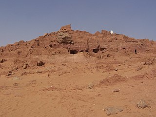
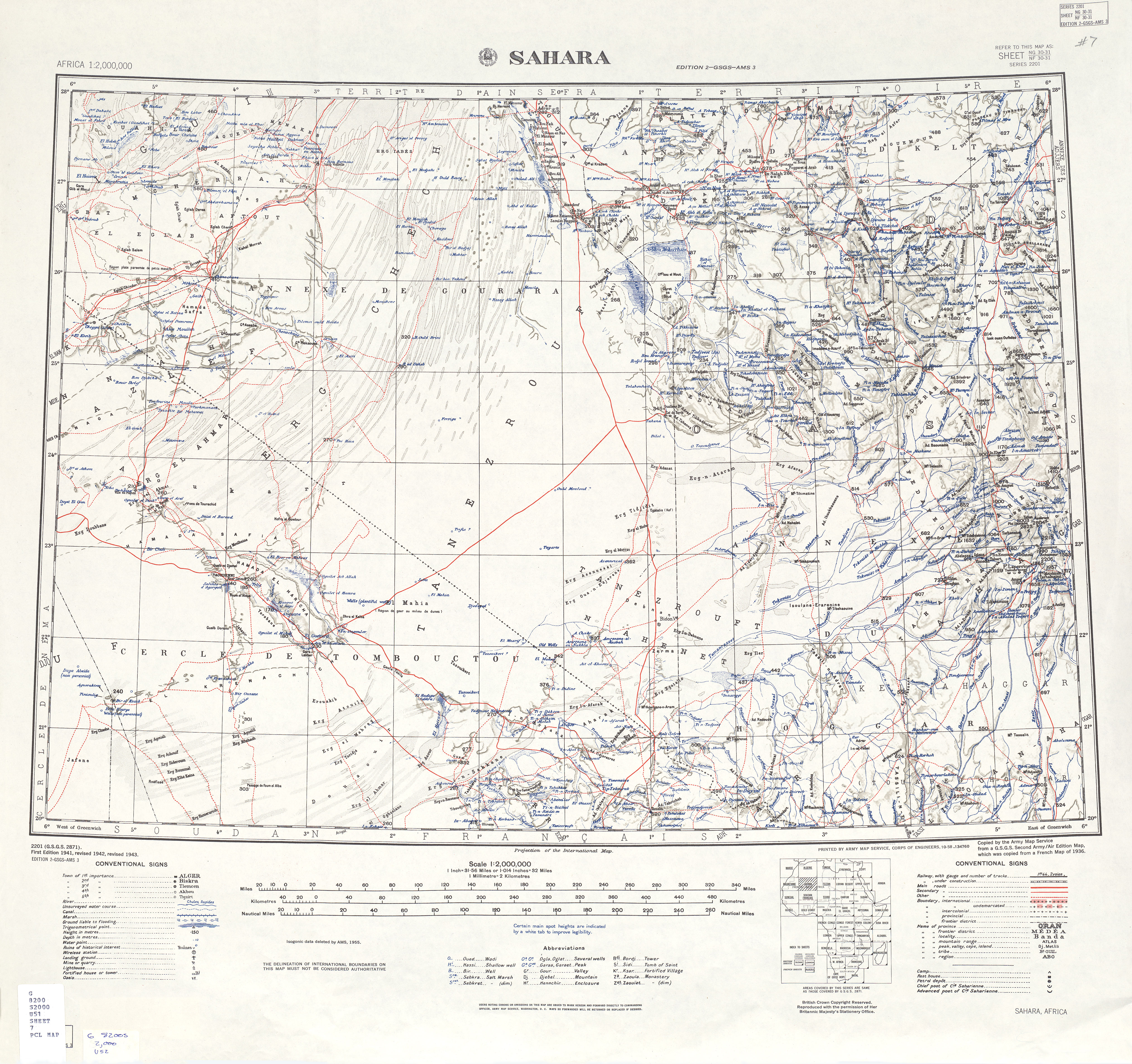
The Tin Hinan Tomb is a monumental tomb located at Abalessa in the Sahara, in the Hoggar Mountains of southern Algeria. The sepulchre was built for Tin Hinan, the Tuareg ancient Queen of the Hoggar (Ahaggar).

<span class="mw-page-title-main">El Ogla, El Oued</span> Commune and town in El Oued Province, Algeria

El Ogla is a town and commune in Robbah District, El Oued Province, Algeria. According to the 2008 census it has a population of 6,102, up from 4,715 in 1998, with an annual growth rate of 2.7%.

References

  1. 1 2 3 "Population: Wilaya de Tamanrasset" (PDF) (in French). Office National des Statistiques Algérie. Archived from the original (PDF) on 13 November 2011. Retrieved 30 May 2013.
  2. "Algeria Communes". Statoids. Retrieved 8 March 2013.
  3. Briggs, L. Cabot (February 1957). "A Review of the Physical Anthropology of the Sahara and Its Prehistoric Implications". Man. 56: 20–23. doi:10.2307/2793877. JSTOR   2793877.
  4. Henri Lhote. "Alla scoperta del Tassili" p. 180-183 ()
  5. "Africa AMS Topographic Maps - Sahara". University of Texal Libraries. Retrieved 31 May 2013.
  6. "Structure relative de la population résidente des ménages ordinaires et collectifs âgée de 6 ans et plus selon le niveau d'instruction et la commune de résidence" (PDF) (in French). Office National des Statistiques Algérie. Archived from the original (PDF) on 13 November 2011. Retrieved 30 May 2013.
  7. "Taux d'analphabétisme et taux d'alphabétisation de la population âgée de 15 ans et plus, selon le sexe et la commune de résidence " (PDF) (in French). Office National des Statistiques Algérie. Archived from the original (PDF) on 13 November 2011. Retrieved 30 May 2013.
  8. "Décret n° 84-365, fixant la composition, la consistance et les limites territoriale des communes. Wilaya de Tamanghasset" (PDF) (in French). Journal officiel de la République Algérienne. 19 December 1984. p. 1496. Archived from the original (PDF) on 5 May 2015. Retrieved 2 March 2013.
Neighbouring towns and cities