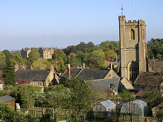
Montacute is a village and civil parish in Somerset, England, 4 miles (6.4 km) west of Yeovil. The village has a population of 831. The name Montacute is thought by some to derive from the Latin "Mons Acutus", referring to the conically acute St Michael's Hill dominating the village to the west. An alternative view is that it is named after Drogo de Montagu, whose family originated from Montaigu-les-Bois, in the arrondissement of Coutances. Mortain held Montacute after 1066, Drogo was a close associate.

Clifton Maybank is a hamlet and civil parish in the English county of Dorset. It is located about a mile southwest of the village of Bradford Abbas. It is known for Clifton Maybank House, a country house with surviving Tudor fabric. Dorset County Council estimate that the population of the parish in 2013 was 40.

Woodspring Priory is a former Augustinian priory. It is near the scenic limestone promontory of Sand Point and Middle Hope, owned by the National Trust, beside the Severn Estuary about 3 miles (5 km) north-east of Weston-super-Mare, within the English unitary authority of North Somerset. Many of the buildings are Grade I listed, and the whole site is scheduled as an ancient monument.
Preston Plucknett is a suburb of Yeovil in Somerset, England. It was once a small village, and a separate civil parish until 1930, when it was absorbed into the neighbouring parishes of Yeovil, Brympton and West Coker. It was listed in the Domesday Book of 1086 as "Preston" when its lord was Ansger of Montacute. In the 13th century, Alan de Plugenet was lord of the manor and added his surname to Preston. Following the 20th century expansion of Yeovil, Preston Plucknett became little more than a suburb of the town. Throughout the centuries the spelling and pronunciation of the name has changed and evolved until it became the present day "Preston Plucknett." The parish of Preston Plucknett was part of the Stone Hundred.

West Pennard is a village and civil parish east of Glastonbury, situated at the foot of Pennard Hill, in the Mendip district of Somerset, England. The parish includes the hamlets of Coxbridge and Woodlands.

South Petherton is a village and civil parish in the South Somerset district of Somerset, England, located 5 miles (8 km) east of Ilminster and 5 miles (8 km) north of Crewkerne. The parish had a population of 3,367 in 2011 and includes the smaller village of Over Stratton and the hamlets of Compton Durville, Drayton, Wigborough and Yeabridge. The River Parrett forms the eastern boundary of the parish. The village is approximately 2 miles (3 km) from East Lambrook, Martock and Lopen.

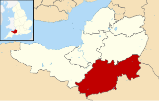
The Grade I listed buildings in Somerset, England, demonstrate the history and diversity of its architecture. The ceremonial county of Somerset consists of a non-metropolitan county, administered by Somerset County Council, which is divided into five districts, and two unitary authorities. The districts of Somerset are West Somerset, South Somerset, Taunton Deane, Mendip and Sedgemoor. The two administratively independent unitary authorities, which were established on 1 April 1996 following the breakup of the county of Avon, are North Somerset and Bath and North East Somerset. These unitary authorities include areas that were once part of Somerset before the creation of Avon in 1974.
South Somerset is a local government district in the English county of Somerset. The South Somerset district occupies an area of 370 square miles (958 km2), stretching from its borders with Devon and Dorset to the edge of the Somerset Levels. The district has a population of about 158,000, and has Yeovil as its administrative centre.

Cothelstone Manor in Cothelstone, Somerset, England was built in the mid-16th century, largely demolished by the parliamentary troops in 1646 and rebuilt by E.J. Esdaile in 1855–56.

The Manor Farmhouse in Meare, Somerset, England, was built in the 14th century as the summer residence of the Abbots from Glastonbury Abbey and is now a farmhouse. Along with its outbuildings the farmhouse has been designated as a Grade I listed building.

The Abbey Farm House in Yeovil, Somerset, England was built around 1420 and has been designated as a Grade I listed building.

Montacute Priory was a Cluniac priory of the Benedictine order in Montacute, Somerset, England.

Forde Abbey is a privately owned former Cistercian monastery in Dorset, England, with a postal address in Chard, Somerset. The house and gardens are run as a tourist attraction while the 1,600-acre (650 ha) estate is farmed to provide additional revenue. Forde Abbey is a Grade I listed building.

The Dovecot At Blackford Farm in Selworthy on Exmoor within the English county of Somerset was probably built in the 11th century. It is a Grade II* listed building, and scheduled monument.

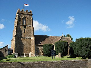
The Anglican Church of St Catherine at Montacute within the English county of Somerset was first built in the 12th century. It is a Grade II* listed building.

Lee Abbey, founded in 1946, is an ecumenical Christian community between Woody Bay and Lynmouth in Devon, England. It is a Grade II listed building.

