Related Research Articles

The River Afan is a river in Wales whose valley formed the territory of the medieval Lords of Afan. The Afan Valley encompasses the upper reaches of the river. The valley is traversed by the A4107 road. Settlements in the area include Cwmafan, Pontrhydyfen and Cymmer. The town of Aberavon, whose name in Welsh Aberafan means 'mouth of the Afan', grew up on the banks of the river and was later subsumed by the town of Port Talbot.

Neath Port Talbot is a county borough in the south-west of Wales. Its principal towns are Neath, Port Talbot, Briton Ferry and Pontardawe. The county borough borders Bridgend County Borough and Rhondda Cynon Taf to the east, Powys and Carmarthenshire to the north; and Swansea to the west.
The Afan Forest Park is a 48-square-mile (120 km2) forest park in Britain. It is set in the Afan Valley in Neath Port Talbot, in south Wales. It is well known for its mountain biking and hiking or hillwalking trails. It is situated seven miles (11 km) from Junction 40 of the M4.

The Maesteg Line is a commuter rail line in South Wales from Bridgend to Maesteg. Services usually operate from Maesteg to Cheltenham Spa and Cardiff Central via the South Wales Main Line and Gloucester to Newport Line.
Abercregan is a village in the community of Cymer and Glyncorrwg, in the Welsh county borough of Neath Port Talbot, Glamorgan. It is situated around 12 kilometres (7.5 mi) north-east of Port Talbot and just west of Cymmer, and is also close to the River Afan. Abercregan was once a thriving mining community but since the decline of the British coal industry, much of the housing has been demolished and most of its inhabitants have moved to neighbouring villages. The 1980s and 1990s saw the closure of the village school, the boys club, post office and the last remaining shop 1989. The local authority decided to turn the school into a Field Study Centre, which was later closed and relocated to Margam Park. The building was demolished following the closure.
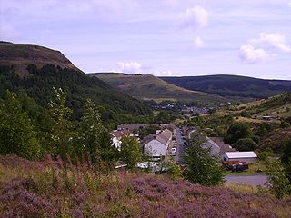
Blaengwynfi is a village in the Afan Valley, in the Rhondda Cynon Taf area of South Wales. It is in the community of Gwynfi and Croeserw,
Treherbert is a village and community situated at the head of the Rhondda Fawr valley in the county borough of Rhondda Cynon Taf, Wales. Historically part of Glamorgan, Treherbert is a former industrial coal mining village which was at its economic peak between 1850 and 1920. Treherbert is the upper most community of the Rhondda Fawr and encompasses the districts of Blaencwm, Blaenrhondda, Tynewydd and Pen-yr-englyn.

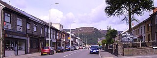
Cwmafan, also known as Cwmavon, is a large village and community in the Afan valley in Wales, lying within Neath Port Talbot County Borough. It had a population of 5,603 in 2001, increasing slightly to 5,615 at the 2011 Census. Cwmafan is known for having a high percentage of Welsh speakers. In many ways it is a suburb of the nearby town of Port Talbot which is less than 2 miles (3 km) to the south. The literal translation of Cwmafan from Welsh to English is complex, Cwm means valley with Afan as the name of the river flowing through, hence the village residing within the Afan Valley. It could be a version of Afon which means river, so literally the "River Valley", this is common in Wales and the UK with many rivers being called Afon or Avon. There is also a Saint Afan, which it is possible the river was named after. There have been other suggestions but none accepted locally.

Aberavon Beach, also known as Aberavon Sands, is a three-mile (5 km) stretch of sandy beach on the north-eastern edge of Swansea Bay in Port Talbot, Wales. With its high breaker waves, it is popular with surfers. Aberavon Beach was awarded Blue Flag status in December 2007 and features in the Good Beach Guide published by the Marine Conservation Society.
Cymmer is a small village in the community of Cymer and Glyncorrwg, in Neath Port Talbot in Wales, set on a hillside in the Afan Valley near the confluence of the River Afan and the River Corrwg. In 2001, Cymmer had a population of 2,883.

Glyncorrwg is a village in the Afan Valley, in southern Wales.
In 1861 the Llynvi Valley Railway was opened in Glamorganshire, Wales, to convey mineral products to the Bristol Channel at Porthcawl. It adopted an earlier tramroad, the Duffryn Llynvi and Porthcawl Railway. The Llynvi and Ogmore Railway was opened in 1865, and the two companies amalgamated to form the Llynvi and Ogmore Railway in 1866. At first Porthcawl harbour was an important destination for onward transport, but this soon declined.

The A4107 road is an A road in Neath Port Talbot County Borough, Wales. It begins in Port Talbot and heads up the Afan Valley in a north easterly direction. It then continues over the moors eastwards until it connects with the A4061 road south west of Treorchy in the Rhondda Valley.
The Rhondda and Swansea Bay Railway was a Welsh railway company formed to connect the upper end of the Rhondda Fawr with Swansea, with the chief objective of transporting coal and other minerals to Swansea docks. It was incorporated in 1882, but at first the connection to Swansea from Briton Ferry was refused.

Gwynfi is an electoral ward of Neath Port Talbot county borough, Wales.
Abergwynfi railway station served the villages of Abergwynfi and Blaengwynfi in Neath Port Talbot, Wales. The station was the terminus of the line from Bridgend via Maesteg.
Blaencwm is a village in the county borough of Rhondda Cynon Taf, Wales, lying at the head the Rhondda Fawr valley. Two collieries were opened here during the Industrial Revolution, the Dunraven Colliery in 1865 and the Glenrhondda Colliery in 1911. Both had closed by 1966 and the sites have since been landscaped, leaving little trace of their industrial past. It is in the historic county of Glamorgan.
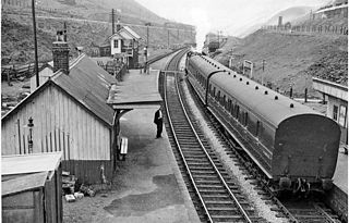
Blaengwynfi railway station served the village of Blaengwynfi, Neath Port Talbot, Wales, from 1890 to 1968 on the Rhondda and Swansea Bay Railway.
The Rhondda Tunnel is an abandoned railway tunnel that runs between the Rhondda and the Afan Valleys in South Wales. It is 3,443 yards (3,148 m) long, making it the third longest railway tunnel in Wales, and the seventeenth longest in the United Kingdom.
Gwynfi United F.C. is a Welsh football club from Blaengwynfi, a village in the Neath Port Talbot area of South Wales. They currently play in the Port Talbot Football League Premier Division. The club played in the Welsh Football League for eleven seasons from 1996–97 until 2006–07 when they resigned from the league and their results from the season were expunged.
References
- 1 2 "Community Profile - Abergwynfi and Blaengwynfi" (PDF).
- 1 2 "Afan Valley: Then And Now". www.digitaldesk.org. Retrieved 18 January 2024.