
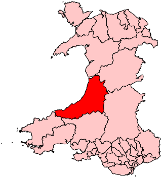
Ceredigion ( ), historically Cardiganshire, is a county in the west of Wales. It borders Gwynedd across the Dyfi estuary to the north, Powys to the east, Carmarthenshire and Pembrokeshire to the south, and the Irish Sea to the west. Aberystwyth is the largest settlement and, together with Aberaeron, is an administrative centre of Ceredigion County Council.

Until 1974, Montgomeryshire was an administrative county in mid Wales, later classed as one of the thirteen historic counties of Wales. It was named after its county town, Montgomery, which in turn was named after one of William the Conqueror's main counsellors, Roger de Montgomerie, who was the 1st Earl of Shrewsbury.

David Davies was a Welsh industrialist and Liberal politician who sat in the House of Commons between 1874 and 1886. Davies was often known as David Davies Llandinam. He is best remembered today for founding Barry Docks.
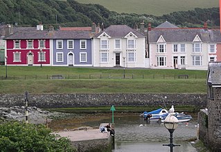
Aberaeron, previously anglicised as Aberayron, is a town, community and electoral ward in Ceredigion, Wales. Located on the coast between Aberystwyth and Cardigan, its resident population was 1,274 in the 2021 census.
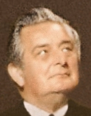
Geraint Wyn Howells, Baron Geraint was a Welsh politician of the Liberal Party and its successor, the Liberal Democrats. He was the Member of Parliament (MP) for Cardigan from 1974 to 1983 and Ceredigion and Pembroke North from 1983 to 1992.
Ceredigion was a parliamentary constituency represented in the House of Commons of the UK Parliament. Created in 1536, the franchise expanded in the late 19th century and on the enfranchisement of women. Its boundaries remained virtually unchanged until 1983. From 1536 until 1885 the area had two seats : a county constituency (Cardiganshire) comprising the rural areas, the other the borough constituency known as the Cardigan District of Boroughs comprising a few separate towns; in 1885 the latter was abolished, its towns and electors incorporated into the former, reduced to one MP. The towns which comprised the Boroughs varied slightly over this long period, but primarily consisted of Cardigan, Aberystwyth, Lampeter and Adpar, the latter now a suburb of Newcastle Emlyn across the Teifi, in Carmarthenshire.

The Local Government (Wales) Act 1994 is an Act of the Parliament of the United Kingdom which amended the Local Government Act 1972 to create the current local government structure in Wales of 22 unitary authority areas, referred to as principal areas in the Act, and abolished the previous two-tier structure of counties and districts. It came into effect on 1 April 1996.

Ceredigion County Council is the governing body for the county of Ceredigion, since 1996 one of the unitary authorities of Wales. The council's main offices are in Aberaeron.

Emrys George Bowen FRGS, FSA, also known as E. G. Bowen, was an internationally renowned geographer with a particular interest in the physical geography and social geography of his native Wales. A diminutive figure, Bowen was on the academic staff of the Department of Geography and Anthropology at the University College of Wales, Aberystwyth, from the 1920s and continued to write and lecture there until his death in 1983.

The United Theological College located in Aberystwyth, in the county of Ceredigion in mid Wales, is a Grade II listed building which was the ministerial training college of the Presbyterian Church of Wales from 1906 to 2003 and an associate college of the University of Wales.
Cardiganshire County Council was the local government authority for the county of Cardiganshire, Wales, between 1889 and 1974. It was superseded by Dyfed County Council.

Aberystwyth is a university and seaside town and a community in Ceredigion, Wales. It is the largest town in Ceredigion and 16 miles (26 km) from Aberaeron, the county's administrative centre. In 2021, the population of the town was 14,640.

Dyfed County Council was the county council of the non-metropolitan county of Dyfed in south west Wales. It operated between 1974 and 1996. The county council was based at County Hall, Carmarthen.
Llanfarian is a village, electoral ward and community in the district county of Ceredigion, Mid-Wales, south of the administrative centre Aberystwyth.

Ceredigion Museum is a museum in Aberystwyth, Ceredigion, Wales.
Ceredigion District Council was one of six district-level authorities in the county of Dyfed, Wales, from 1974 until 1996. The district had an identical area to the pre-1974 administrative county of Cardiganshire. From its creation in 1974 the district used the name "Ceredigion" rather than "Cardiganshire", which had been used for the former county council. Further local government reorganisation in 1996 saw Dyfed County Council abolished and Ceredigion become a unitary authority, with the district council taking over county-level services to become Ceredigion County Council.

Bronglais Hospital is an Acute District General Hospital in Aberystwyth, Wales. It is managed by Hywel Dda University Health Board. It is the only acute hospital within mid-Wales and is the main hospital for the students of Aberystwyth University.
Llandeilo Rural District Council was a local authority in east Carmarthenshire, Wales created in 1894. The first election to the authority was held in December 1894.
Carmarthen Rural District Council was a local authority in the central part of Carmarthenshire, Wales created in 1894. The first election to the authority was held in December 1894.

The flag of Ceredigion is the de facto flag of Ceredigion, Wales. The earliest source referring to the flag dates back to 1611. The flag enjoys widespread usage throughout the county.
