Flora
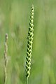
There are grasses such as great burnet, cock's-foot, creeping bent, meadow foxtail, Yorkshire fog and crested dog's tail. [1]
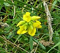
Flowering plants covering the flood meadow include meadow vetchling, ox eye daisy, common sorrel, red clover, creeping thistle, meadowsweet, ribwort plantain and meadow buttercup. There are "distinct stands throughout the grassland" of common bistort, and some areas which contain common meadow rue, and pepper saxifrage. [1]
Meadow vetchling at Acaster South Ings
Sorrel or dock at the site
Red clover at the site
Creeping thistle at the site
Meadowsweet at the site
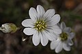
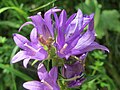
The site is protected, by earth dykes, from potential flooding from the adjacent River Ouse. These dykes provide plant habitat which is drier than the flood meadows. Some plants which prefer this drier habitat are meadow cranesbill, field mouse ear and clustered bellflower. Along the riverside are trees and shrubs such as osier and hawthorn, and plants taller than those in the meadows, including tansy, butterbur, common mugwort, reed canary grass and great willowherb. [1]
Looking north across Acaster South Ings: grassland (left), dyke (right), riverside shrubs (background)
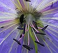
Meadow cranesbill at Acaster South Ings
Field mouse ear
Clustered bellflower
Tansy at the site
Osiers at the site


