Related Research Articles

Cadmore, also known as Cadmore End, is a village in the civil parish of Lane End in the English county of Buckinghamshire.
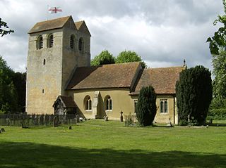
Fingest is a village in Buckinghamshire, England. It is in the Chiltern Hills near the border with Oxfordshire. It is about six miles WSW of High Wycombe. It lies in the civil parish of Hambleden.
Frieth is a village in the parish of Hambleden, in Buckinghamshire, England. It lies on the top of "Frieth Hill", which is part of the chalk escarpments of the Chiltern Hills.

Hambleden is a small village and civil parish in south-west Buckinghamshire, England. The village is around 4 miles (6.4 km) west of Marlow, and around 3 miles (4.8 km) north-east of Henley-on-Thames in Oxfordshire.
Lane End is a village and civil parish in Buckinghamshire, England. It is just south of the M40 from High Wycombe, about 2 miles (3.2 km) west of Booker. The village is twinned with Saint-Pierre-d'Oléron in France.

Lillingstone Lovell is a village and civil parish in north Buckinghamshire, England. It is located around 4 miles (6.4 km) north of Buckingham and 8 miles (13 km) west of Milton Keynes, and around 5 miles (8 km) south of Towcester in the neighbouring county of Northamptonshire. Silverstone Circuit is located just over 2 miles (3.2 km) north-west of Lillingstone Lovell.
Great Marlow is a civil parish within Wycombe district in the English county of Buckinghamshire, lying north of the town of Marlow and south of High Wycombe. The parish includes the hamlets of Bovingdon Green, Burroughs Grove, Chisbridge Cross and Marlow Common. Prior to November 2007 the major settlement in Great Marlow was Marlow Bottom which has now become a civil parish in its own right.
Wycombe is a constituency represented in the House of Commons of the UK Parliament since 2010 by Steve Baker, a Conservative.
Beaconsfield is a constituency in Buckinghamshire represented in the House of Commons of the UK Parliament since 2019 by Joy Morrissey of the Conservative Party. She succeeded Independent and former Conservative Dominic Grieve, whom she defeated following his suspension from the party. The constituency was established for the February 1974 general election.

Pishill is a hamlet in Pishill with Stonor civil parish about 5 miles (8 km) north of Henley-on-Thames in South Oxfordshire. It is in the Stonor valley in the Chiltern Hills about 430 feet (130 m) above sea level.
The Counties Act 1844, which came into effect on 20 October 1844, was an Act of Parliament of the United Kingdom which eliminated many outliers or exclaves of counties in England and Wales for civil purposes. The changes were based on recommendations by a boundary commission, headed by the surveyor Thomas Drummond and summarized in a schedule attached to the Parliamentary Boundaries Act 1832. This also listed a few examples of civil parishes divided by county boundaries, most of which were dealt with by later legislation.
Wheatfield is a civil parish and deserted medieval village about 4 miles (6.4 km) south of Thame in Oxfordshire. Wheatfield's toponym is derived from the Old English for "white field", referring to the ripe crops that the Anglo-Saxons grew on its fertile land. Few of Wheatfield's buildings remain today except the Church of England parish church of Saint Andrew, the former rectory and the former outbuildings of the no-longer-standing manor house.
Lewknor is a village and civil parish about 5 miles (8 km) south of Thame in Oxfordshire.The civil parish includes the villages of Postcombe and South Weston. The 2011 Census recorded the parish's population as 663.

Pyrton is a small village and large civil parish in Oxfordshire about 1 mile (1.6 km) north of the small town of Watlington and 5 miles (8 km) south of Thame. The 2011 Census recorded the parish's population as 227. The toponym is from the Old English meaning "pear-tree farm".

Widford is a deserted medieval village on the River Windrush about 1.5 miles (2.4 km) east of Burford in West Oxfordshire. The village was an exclave of Gloucestershire until 1844.
Marlow Urban District was a local government authority in the administrative county of Buckinghamshire, England, between 1896 and 1974.

Pishill with Stonor is a civil parish in the high Chilterns, South Oxfordshire. It includes the villages of Pishill and Stonor, and the hamlets of Maidensgrove and Russell's Water. Pishill with Stonor was formed by the merger of the separate civil parishes of Pishill and Stonor in 1922. In 2011 it had a human population of 304 across its 10.54 km².
References
- ↑ Oxlade Family History
- 1 2 A History of the County of Oxford: Volume 8: Lewknor and Pyrton hundreds
- ↑ The Townsend Papers
- ↑ Page, William, ed. (1925). Victoria County History of Buckinghamshire: Volume 3: Great Marlow. pp. 65–77.
- ↑ Vision of Britain website: Fingest and Lane End Archived 2011-06-28 at the Wayback Machine
- ↑ Frieth History website: Ackhampstead