Ackleton

Last updated

Ackleton
The Red Cow at Ackleton, closed for the afternoon - geograph.org.uk - 749533.jpg
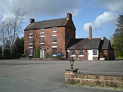
The Red Cow public house, Ackleton
Shropshire UK location map.svg
Red pog.svg
Ackleton
Location within Shropshire
OS grid reference SO769988
Civil parish
Unitary authority
Ceremonial county
Region
Country England
Sovereign state United Kingdom
Post town WOLVERHAMPTON
Postcode district WV6
Dialling code 01746
Police West Mercia
Fire Shropshire
Ambulance West Midlands
UK Parliament
List of places
UK
England
Shropshire
52°35′10″N2°20′24″W / 52.586°N 2.340°W / 52.586; -2.340

Ackleton is a village in the English county of Shropshire. It is in the civil parish of Worfield.

Contents

Situated some seven miles (11 kilometers) from the market town of Bridgnorth, this village is the home of the two pub and restaurants The Red Cow and The Folley. Convenient for both Wolverhampton and Telford, this rural retreat is surrounded by open fields and views. It also shares its territory with Badger Dingle, which is a forest area often visited by walkers and hikers. Ackleton is most situated by small quaint cottages. The open fields are great for walking or hiking. The area attracts many dog walkers.

The architecture for the housing in Ackleton dates back to Tudor times.

Ackleton is believed to have inspired the fictional village of Eckleton in writings of P. G. Wodehouse, whose parents lived in nearby Stableford. [1]

See also

Related Research Articles

<span class="mw-page-title-main">Church Stretton</span> Market town in Shropshire, England

Church Stretton is a market town and civil parish in Shropshire, England, 13 miles (21 km) south of Shrewsbury and 15 miles (24 km) north of Ludlow. The population in 2011 was 4,671.

<span class="mw-page-title-main">Clun</span> Human settlement in England

Clun is a town in south west Shropshire, England, and the Shropshire Hills Area of Outstanding Natural Beauty. The 2011 census recorded 680 people living in the town. Research by the Campaign for the Protection of Rural England suggests that Clun is one of the most tranquil locations in England.

<span class="mw-page-title-main">Donnington, Telford</span> Human settlement in England

Donnington is an area / housing estate located in the borough of Telford and Wrekin and ceremonial county of Shropshire, England. The population of Donnington Ward was 6,883 at the 2011 census.

<span class="mw-page-title-main">Ludlow (UK Parliament constituency)</span> Parliamentary constituency in the UK

Ludlow is a constituency in Shropshire represented in the House of Commons of the UK Parliament since 2005 by Philip Dunne, a member of the Conservative Party.

<span class="mw-page-title-main">Rodington</span> Human settlement in England

Rodington is a village in Shropshire, England. Situated between the towns of Wellington and Shrewsbury it lies on the relatively level Shropshire plain and just within the borough of Telford & Wrekin.

<span class="mw-page-title-main">Cosford, Shropshire</span> Village in Shropshire, England

Cosford is a village in Shropshire, England. It is located on the A41 road, which is itself just south of junction 3 on the M54 motorway. The village is very small and is mostly made up of dwellings that house Royal Air Force personnel who work at the adjacent RAF Cosford.

<span class="mw-page-title-main">Melverley</span> Human settlement in England

Melverley is a village in Shropshire, England, situated on the River Severn and the River Vyrnwy, near the Powys hills and the border with Wales. The population of the civil parish at the 2011 census was 156. The village, and the large rural area that surrounds it, was years ago famous for flooding from the nearby rivers but since the extensive defences being installed in Shrewsbury and improvements to the flood defences in and around the Melverley area flooding causes no problems for the majority of residents. It is a controlled flood area, meaning that water is allowed to flow across the open fields and held for a few hours until the river levels fall. Melverley Green is a small village to the north of Melverley.

<span class="mw-page-title-main">Badger, Shropshire</span> Human settlement in England

Badger is a village and civil parish in Shropshire, England, about six miles north-east of Bridgnorth. The parish had a population of 134 according to the 2001 census, falling to 126 at the 2011 census.

<span class="mw-page-title-main">Worfield</span> Human settlement in England

Worfield is a village and civil parish in Shropshire in the West Midlands, England. It is 120 miles (190 km) northwest of London and 10 miles (16 km) west of Wolverhampton. It is north of Bridgnorth and southeast of Telford. The parish, which includes the hamlet of Chesterton, is an extensive one which lies on the River Worfe. The name Worfield comes from its location on the river Worfe and the surrounding countryside (fields).

<span class="mw-page-title-main">Penygarreg Lane Halt railway station</span>

Penygarreg Lane is a halt on the Cambrian Heritage Railways' line in Shropshire. It is on the northern edge of the village of Pant, north of the disused Pant station. Prior to its construction, trains stopped here only to reverse back towards Llynclys and passengers could not board or alight here.

<span class="mw-page-title-main">Hilton, Shropshire</span> Human settlement in England

Hilton is a village in Shropshire, England.

<span class="mw-page-title-main">Wyken, Shropshire</span> Human settlement in England

Wyken is a hamlet in the English county of Shropshire.

<span class="mw-page-title-main">Allscott</span> Human settlement in England

Allscott is a small village 3 miles (4.8 km) north west of Wellington, Shropshire. The River Tern flows by. It falls within the parish of Wrockwardine and the borough of Telford and Wrekin. Nearby is the small village of Walcot.

<span class="mw-page-title-main">George Bromley (politician)</span> Member of the Parliament of England

George Bromley was an English lawyer, landowner, politician and judge of the Mid-Tudor and Elizabethan period, a member of an important Shropshire legal and landed gentry dynasty. Although his career was overshadowed by that of his brother Thomas Bromley, George Bromley was of considerable importance in the affairs of the Welsh marches and the Inner Temple. He was an MP for Liskeard 1563, Much Wenlock in 1558 and 1559 and Shropshire in 1571 and 1572.

Francis Bromley was an English politician. A member of an important legal and landowning dynasty of the Shropshire landed gentry, his career was cut short by an early death. He was a Member (MP) of the Parliament of England for Shropshire in 1584.

The Shropshire County Cricket League is a league cricket competition based in the county of Shropshire, England.

Worfield is a civil parish in Shropshire, England. It contains 77 listed buildings that are recorded in the National Heritage List for England. Of these, one is listed at Grade I, the highest of the three grades, four are at Grade II*, the middle grade, and the others are at Grade II, the lowest grade. The parish includes the village of Worfield, and other villages and smaller settlements, including Allscot, Ackleton, Chesterton, Hilton, Roughton, Stableford, Swancote, and Wyken, and is otherwise rural. Most of the listed buildings are houses, cottages, farmhouses and farm buildings, the earlier of which are timber framed, or have timber framed cores. The other listed buildings include a church, the churchyard wall and gate piers, a country house and associated dovecote, two bridges, a watermill, public houses, a school, a war memorial, and two telephone kiosks.

<span class="mw-page-title-main">Stockton, Worfield</span> Human settlement in England

Stockton is a village and civil parish 17 miles (27 km) south east of Shrewsbury, in the Shropshire district, in the county of Shropshire, England. The parish includes the village of Norton and the hamlet of Higford. In 2011, the parish had a population of 331. The parish touches Astley Abbotts, Badger, Barrow, Beckbury, Broseley, Sutton Maddock and Worfield.

<span class="mw-page-title-main">Davenport House, Worfield</span> Historic building in Worfield, Shropshire

Davenport House is an historic country house in the English village of Worfield, Shropshire. Located to the southwest of the village centre, it was built around 1727, and is now a Grade I listed building. Its grounds are listed at Grade II status.

<span class="mw-page-title-main">Rudge, Shropshire</span> Human settlement in England

Rudge is a settlement and civil parish about 6 miles east of Bridgnorth, in the Shropshire district, in the ceremonial county of Shropshire, England. In 2001 the parish had a population of 98. The parish touches those of Claverley and Worfield within Shropshire and Pattingham and Patshull and Trysull and Seisdon in Staffordshire. Rudge shares a parish council with Worfield.

References

  1. Dickins, Gordon (1987). An Illustrated Literary Guide to Shropshire. Shropshire Libraries, Shrewsbury. pp. 82–83. ISBN   0-903802-37-6.

Commons-logo.svg Media related to Ackleton at Wikimedia Commons