
Featherstone is a town and civil parish in the City of Wakefield, West Yorkshire, England, two miles south-west of Pontefract. Historically part of the West Riding of Yorkshire, in 2011 it had a population of 15,244. Featherstone railway station is on the Pontefract Line.
Aike is a hamlet and former civil parish, now in the parish of Lockington, in the East Riding of Yorkshire, England. The hamlet is centred around a single developed street, which lies to the east of the Yorkshire Wolds. Aike is approximately 4 miles (6 km) north of Beverley and approximately 0.4 miles (1 km) from the west bank of the River Hull. It is approached by a 2.5-mile (4 km) lane which is a no-through road that does not continue beyond the village, although a farm track continues as far as a bridge across the Beverley and Barmston Drain. In 1931 the parish had a population of 48.

Brigham is a small village and former civil parish, now in the parish of Foston on the Wolds, in the East Riding of Yorkshire, England. It is situated approximately 4 miles (6 km) south-east from Driffield, 15 miles (24 km) north of Hull city centre, and to the west of the B1249 road. In 1931 the parish had a population of 66. Brigham was formerly a township in the parish of Foston on the Wolds, from 1866 Brigham was a civil parish in its own right, on 1 April 1935 the parish was abolished to form Foston.

Gembling is a hamlet and former civil parish, now in the parish of Foston, in the East Riding of Yorkshire, England. It is situated approximately 8 miles (13 km) south-west from the coastal resort of Bridlington and 2.5 miles (4 km) north from the village of North Frodingham. In 1931 the parish had a population of 80.

Thurstonland is a village in the civil parish of Kirkburton, in Kirklees, West Yorkshire, England. It has a population of almost 400.

Knedlington is a small hamlet and former civil parish, now in the parish of Asselby, in the East Riding of Yorkshire, England. It is situated approximately 1 mile (1.6 km) west of the market town of Howden and lies to the west of the B1228 road. The M62 motorway is just over 1 mile to the south-east. Village landmarks include Knedlington Manor, Knedlington Hall, and woodland. Knedlington Hall was protected as a Grade II* listed building in 1966. In 1931 the parish had a population of 86.

South Dalton is a village and former civil parish, now in the parish of Dalton Holme, in the East Riding of Yorkshire, England. It is situated 6 miles (10 km) north-east of Market Weighton and 5 miles (8 km) north-west of Beverley. Etton lies 2 miles (3.2 km) to the south-east. North Dalton is 5 miles (8 km) north-west, with the villages of Middleton on the Wolds and Lund between. In 1931 the parish had a population of 233. On 1 April 1935 the parish was abolished and merged with Holme on the Wolds to form "Dalton Holme".
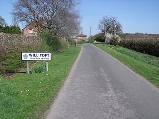
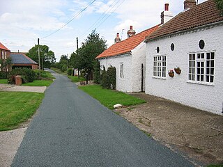
Willitoft is a hamlet and former civil parish, now in the parish of Bubwith, in the East Riding of Yorkshire, England. It is situated just south of the A163 road and west of the B1228 road. It is approximately 8 miles (13 km) east of Selby and 7 miles (11 km) north of Goole. In 1931 the parish had a population of 53.
Towthorpe is a hamlet and former civil parish, now in the parish of Fimber, in the East Riding of Yorkshire, England. It is situated in the Yorkshire Wolds just north of the B1248 road, approximately 8 miles (13 km) north-west of Driffield and 2 miles (3 km) south-west of Sledmere. In 1931 the parish had a population of 66. The deserted medieval village is a scheduled monument.

Thorpe le Street is a hamlet and former civil parish, now in the parish of Hayton, in the East Riding of Yorkshire, England. It is situated approximately 3.5 miles (5.6 km) south-east of the market town of Pocklington and 3 miles (4.8 km) north-west of the market town of Market Weighton. It lies to the south of the A1079 road. In 1931 the parish had a population of 28. Thorpe le Street was formerly a township in the parish of Nun-Burn-holme, in 1866 Thorpe le Street became a civil parish on 1 April 1935 the parish was abolished and merged with Hayton. The Roman Road known as Cade's Roadis thought likely to have passed through it, which would explain "-le-Street".

Thornholme is a hamlet and former civil parish, now in the parish of Burton Agnes, in the East Riding of Yorkshire, England. It is situated approximately 5 miles (8 km) south-west of the town of Bridlington and 1 mile (1.6 km) north-east of the village of Burton Agnes. It lies on the A614 road. In 1931 the parish had a population of 91.
Meaux is a hamlet and former civil parish, now in the parish of Wawne, in the East Riding of Yorkshire, England. It is about 6+1⁄2 miles (10 km) north of Hull city centre and 3+1⁄2 miles (6 km) east of Beverley. In 1931 the parish had a population of 73.

Great Kelk is a village and former civil parish, now in the parish of Kelk, in the East Riding of Yorkshire, England. It is situated approximately 7.5 miles (12.1 km) south-west of Bridlington. In 1931 the parish had a population of 117.

Laytham is a village and former civil parish, now in the parish of Foggathorpe, in the East Riding of Yorkshire, England. It is situated approximately 6 miles (9.7 km) north of Howden town centre and 3 miles (5 km) west of Holme-on-Spalding-Moor. In 1931 the parish had a population of 63.

Eastburn is a hamlet and former civil parish, now in the parish of Kirkburn, in the East Riding of Yorkshire, England. It is situated in the Yorkshire Wolds on the A164 road, approximately 2.5 miles (4 km) south-west of Driffield town centre and 3 miles (5 km) north-west of the village of Hutton Cranswick. In 1931 the parish had a population of 27.

Haisthorpe is a village and former civil parish, now in the parish of Carnaby, in the East Riding of Yorkshire, England. It is situated approximately 4 miles (6 km) south-west of Bridlington town centre. It lies on the A614. In 1931 the parish had a population of 127.

Gransmoor is a hamlet and former civil parish, now in the parish of Burton Agnes, in the East Riding of Yorkshire, England. It is situated approximately 6 miles (10 km) south-west of the town of Bridlington and 3 miles (5 km) south-east of the village of Burton Agnes. In 1931 the parish had a population of 83.

Bolton is a village and former civil parish, now in the parish of Fangfoss, in the East Riding of Yorkshire, England. It is situated approximately 10 miles (16 km) to the east of the city of York and 3 miles (5 km) north-west of the town of Pocklington. In 1931 the parish had a population of 130. Bolton was formerly a township in the parish of Bishop Wilton, from 1866 Bolton was a civil parish in its own right, on 1 April 1935 the parish was abolished and merged with Fangfoss, part also went to form Bishop Wilton.
Sutton is a small village and former civil parish, now in the parish of Norton, in the City of Doncaster in South Yorkshire, England. It lies at approximately 53° 36' 20" North, 1° 10' West, at an elevation of around 26 feet above sea level, west of Askern and south of Campsall. In 1931 the civil parish had a population of 156.

Hawksworth is a village 1 mile (1.6 km) west of the town of Guiseley in West Yorkshire, England. It is located to the south of Menston and north of Baildon.

