
The Via Egnatia was a road constructed by the Romans in the 2nd century BC. It crossed Illyricum, Macedonia, and Thracia, running through territory that is now part of modern Albania, North Macedonia, Greece, and European Turkey as a continuation of the Via Appia.

In ancient Rome, thermae and balneae were facilities for bathing. Thermae usually refers to the large imperial bath complexes, while balneae were smaller-scale facilities, public or private, that existed in great numbers throughout Rome.
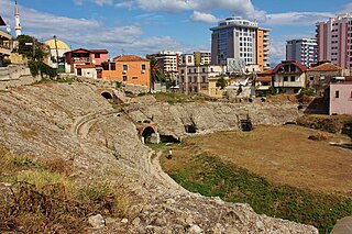
The city of Epidamnos, later the Roman Dyrrachium, was founded in 627 BC in Illyria by Greeks from Corinth and Corcyra.
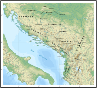
Taulantii or Taulantians were an Illyrian people that lived on the Adriatic coast of southern Illyria. They dominated at various times much of the plain between the rivers Drin (Drilon) and Vjosa (Aoös). Their central area was the hinterland of Epidamnos-Dyrrhachion, corresponding to present-day Tirana and the region between the valleys of Mat and Shkumbin (Genusus). The Taulantii are among the oldest attested Illyrian peoples, who established a powerful kingdom in southern Illyria. They are among the peoples who most marked Illyrian history, and thus found their place in the numerous works of historians in classical antiquity.

Apollonia was an Ancient Greek trade colony which developed into an independent polis, and later a Roman city, in southern Illyria. It was located on the right bank of the Aoös/Vjosë river, approximately 10 km from the eastern coast of the Adriatic Sea. Its ruins are situated in the county of Fier, close to the village of Pojan, in Albania.

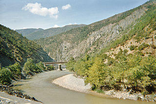
The Vjosa or Aoös is a river in northwestern Greece and southwestern Albania. Its total length is about 272 kilometres (169 mi), of which the first 80 kilometres (50 mi) are in Greece, and the remaining 192 kilometres (119 mi) in Albania. Its drainage basin is 6,706 km2 (2,589 sq mi) and its average discharge is 195 m3/s (6,900 cu ft/s). The main tributaries are Voidomatis, Sarantaporos, Drino and Shushicë.
The Shkumbin, also known as Shkembi, is a river in Southern Europe. It is 181.4 km (112.7 mi) long and its drainage basin is 2,444 km2 (944 sq mi). Its average discharge is 61.5 m3/s (2,170 cu ft/s).

Byllis or Bullis or Boullis (Βουλλίς) was an ancient city and the chief settlement of the Illyrian tribe of the Bylliones, traditionally located in southern Illyria. In Hellenistic times the city was either part of Illyria or Epirus. In Roman times it was included within Epirus Nova, in the province of Macedonia. The remains of Byllis are situated north-east of Vlorë, 25 kilometers from the sea in Hekal, Fier County, Albania. Byllis was designated as an archaeological park on 7 April 2003 by the government of Albania.

Amantia was an ancient city and the main settlement of the Amantes, traditionally located in southern Illyria in classical antiquity. In Hellenistic times the city was either part of Illyria or Epirus. In Roman times it was included within Epirus Nova, in the province of Macedonia. The site has been identified with the village of Ploçë, Vlorë County, Albania. Amantia was designated as an archaeological park on 7 April 2003 by the government of Albania.

The Suburban Baths are a building in Pompeii, Italy, a town in the Italian region of Campania that was buried by the eruption of Mount Vesuvius in 79 AD, which consequently preserved it.
The Parthini, Partini or Partheni were an Illyrian tribe that lived in the inlands of southern Illyria. They likely were located in the Shkumbin valley controlling the important route between the Adriatic Sea and Macedonia, which corresponded to the Via Egnatia of Roman times. Consequently, their neighbours to the west were the Taulantii and to the east the Dassaretii in the region of Lychnidus.

Oricum was a harbor on the Illyrian coast that developed in an Ancient Greek polis at the south end of the Bay of Vlorë on the southern Adriatic coast. It was located at the foot of the Akrokeraunian Mountains, the natural border between ancient Epirus and Illyria. Oricum later became an important Roman city between the provinces of Epirus Vetus and Epirus Nova in Macedonia. It is now an archaeological park of Albania, near modern Orikum, Vlorë County. Oricum holds such a strategic geographical position that the area has been in continuous usage as a naval base from antiquity to the present-days.
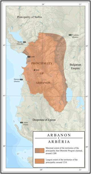
Arbanon was a medieval principality in present-day Albania, ruled by the native Progoni family, and the first Albanian state to emerge in recorded history. The principality was established in 1190 by the Albanian archon Progon in the region surrounding Kruja, to the east and northeast of Venetian territories. Progon was succeeded by his sons Gjin and then Demetrius (Dhimitër), who managed to retain a considerable degree of autonomy from the Byzantine Empire. In 1204, Arbanon attained full, though temporary, political independence, taking advantage of the weakening of Constantinople following its pillage during the Fourth Crusade. However, Arbanon lost its large autonomy ca. 1216, when the ruler of Epirus, Michael I Komnenos Doukas, started an invasion northward into Albania and Macedonia, taking Kruja and ending the independence of the principality. From this year, after the death of Demetrius, the last ruler of the Progoni family, Arbanon was successively controlled by the Despotate of Epirus, then by the Bulgarian Empire and, from 1235, by the Empire of Nicaea.
Bradashesh is a village and a former municipality in the Elbasan County, central Albania. At the 2015 local government reform it became a subdivision of the municipality Elbasan. The population at the 2011 census was 10,700. The municipal unit consists of the villages Bradashesh, Balez Lart, Balez Poshte, Kusarth, Kozan, Karakullak, Letan, Rrile, Shtemaj, Ulem, Katund i Ri, Fikas, Petresh, Shemhill, Shingjon, Recan and Gurabardhë.
The Dassaretii were an Illyrian people that lived in the inlands of southern Illyria, between present-day south-eastern Albania and south-western North Macedonia. Their territory included the entire region between the rivers Asamus and Eordaicus, the plateau of Korça locked by the fortress of Pelion and, towards the north it extended to Lake Lychnidus up to the Black Drin. They were directly in contact with the regions of Orestis and Lynkestis of Upper Macedonia. Their chief city was Lychnidos, located on the edge of the lake of the same name. One of the most important settlements in their territory was established at Selcë e Poshtme near the western shore of Lake Lychnidus, where the Illyrian Royal Tombs were built.
Pelion, also Pellion or Pelium was an ancient fortified settlement traditionally located in Illyria, near the Tsangon Pass, on the border with Macedonia. Pelion is generally placed in eastern Dassaretis very close to the historical border with Macedonia, however its precise location is uncertain and various theories have been proposed for the site of the settlement.
The Albanoi were an Illyrian tribe. They were possibly first mentioned by Hecataeus of Miletus under the name Abroi. Ptolemy is the first author who mentions them under the name Albanoi. Their central settlement was called Albanopolis (Ἀλβανόπολις) and was located roughly between the Mat and Shkumbin rivers, in central Albania. The archaeological site of Zgërdhesh has been identified as the likely location of Albanopolis. Stephanus of Byzantium who reproduced Hecataeus added an entry for another settlement named Arbon in Illyria whose inhabitants were called Arbonioi or Arbonites. Another Arbon was recorded by Polybius. John of Nikiû wrote in the 7th century CE about a people known as Arbanitai in the Greek translation of the manuscript.
Caenophrurium was a settlement in the Roman province of Europa, between Byzantium and Heraclea Perinthus. It appears in late Roman and early Byzantine accounts. Caenophrurium translates as the "stronghold of the Caeni", a Thracian tribe.

Polisi is a massif located in the municipality of Librazhd, in eastern Albania. Its highest peak, Maja e Polisit, reaches a height of 1,974 m (6,476 ft). The other important peak of the massif is Mali Plak, standing at 1,943 m (6,375 ft) above sea level.

The Stabian Baths are an ancient Roman bathing complex in Pompeii, Italy, the oldest and the largest of the 5 public baths in the city. Their original construction dates back to ca. 125 BC, making them one of the oldest bathing complexes known from the ancient world. They were remodelled and enlarged many times up to the eruption of Vesuvius in 79 AD.

 Entrance of the frigidarium
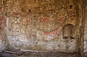 Rear wall of the apodyterium


