This article is about the central locality of Adelaide. For the greater metropolitan area, see Adelaide. For the local government area, see City of Adelaide.
Adelaide city centre (Kaurna: Tarndanya)[3] is the inner city locality of Greater Adelaide, the capital city of South Australia. It is known by locals simply as "the City" or "Town" to distinguish it from Greater Adelaide and from the City of Adelaide local government area (which also includes North Adelaide and from the Park Lands around the whole city centre). The residential population was 18,202 in the 2021 census, with a local worker population of 130,404.[4]
Adelaide city centre was planned in 1837 on a greenfield site following a grid layout, with streets running at right angles to each other. It covers an area of 4.33 square kilometres (1.67 square miles) and is surrounded by 6.68 square kilometres (2.58 square miles) of park lands.[5][note 1] Within the city are five parks: Victoria Square in the exact centre and four other, smaller parks.
Names for elements of the city centre are as follows:
The "city square mile" (in reality 1.67 square miles or 4.33 square kilometres) is the constructed area bordered by North, East, South and West Terraces.
The "central business district" (CBD) is an alternative term, but more accurately describes the intensively developed northern half of the city, which contains a multitude of commercial, cultural and entertainment premises, restaurants and high-rise apartments. The southern, lower-density half mainly contains small businesses, restaurants and, residentially, a mix of mansions, houses and conserved 19th century cottages, and (fewer) high-rise apartments.
Before the British colonisation of South Australia, the Adelaide Plains, on which Adelaide was built, were home to the Kaurna group of Aboriginal Australians. The colony of South Australia was established in 1836 at Glenelg, and the city itself established in 1837. The location and characteristic grid layout of the city and North Adelaide, as well as the surrounding parklands, were the result of the work of Colonel William Light (1786–1839), who was the first Surveyor General of South Australia. The area where the Adelaide city centre now exists was once known as "Tarndanya",[6] the Kaurna word for as "male red kangaroo rock", which was the name used for an area along the south bank of what is now known as the River Torrens (Karrawiri Pari), which flows through Adelaide.
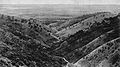
This view shows about 60per cent of the city centre, and the south-eastern suburbs and Adelaide Hills in 1935
Adelaide was not as badly affected by the 1860s economic depression in Australia as other gold rush cities like Sydney and Melbourne, allowing it to prosper. Historian F.W. Crowley noted that the city was full of elite upper-class citizens which provided a stark contrast to the grinding poverty of the labour areas and slums outside the inner city ring. Due to its historic wealth during the 20th century, the city retains a notable portion of Victorian architecture.[citation needed]
Adelaide is separated from its greater metropolitan area by a ring of public parklands on all sides. The so-called "square mile" within the park lands is defined by a small area of high rise office and apartment buildings in the centre north, around King William Street, which runs north-to-south through the centre. Surrounding this central business district are a large number of medium to low density apartments, townhouses and detached houses which make up the residential portion of the city centre.
Layout
The layout of Adelaide, sometimes referred to as "Light's Vision", features a cardinal directiongrid pattern of wide streets and terraces and five large public squares: Victoria Square in the centre of the city, and Hindmarsh, Light, Hurtle and Whitmore Squares in the centres of each of the four quadrants of the Adelaide city centre. These squares occupy 32 of the 700 numbered town acre allotments on Light's plan.[citation needed]
All east–west roads change their names as they cross King William Street, except for North and South terraces.[7] They also alternate between being wide and narrow, 99 and 66 feet (30 and 20m), except for the central Grote and Wakefield which are extra-wide, 132 feet (40m),[8] along with the surrounding four terraces.[9] In the south half of the city, in several places the Adelaide City Council has constructed wide footpaths and road markings to restrict traffic to a lesser number of lanes than the full width of the road could support.[citation needed]
The street pairs, design widths, and town acres in Light's Vision are illustrated in this diagram:
The streets and squares were named by a committee of a number of prominent settlers after themselves, after early directors of the South Australian Company, after Colonisation Commissioners of South Australia (appointed by the British government to oversee implementation of the acts that established the colony), and after various notables involved in the establishment of the colony.
All members of the committee (except Stephens) had one or more of the streets and squares in the Adelaide city centre and North Adelaide named after themselves. Brown Street, named for John Brown, was subsequently subsumed as a continuation of Morphett Street in 1967. In the same year, Hanson Street, named for Richard Hanson, was subsumed as a continuation of Pulteney Street.
The squares were named after:
Victoria – the regent, Princess Victoria, later Queen Victoria
The Adelaide City Council began the process of dual naming all of the city squares, each of the parks making up the parklands which surround the city centre and North Adelaide, and other sites of significance to the Kaurna people in 1997.[17] The naming process, which assigned an extra name in the Kaurna language to each place, was mostly completed in 2003,[18] and the renaming of 39 sites finalised and endorsed by the council in 2012.[19]
Victoria Square – Tarntanyangga ('red kangaroo dreaming')
The population was 18,202 in the 2021 census, 41 percent born in Australia.[24] The next most common countries of birth were China 15.7%, India 3.7%, England 3.6%, Malaysia 3.6%, and Hong Kong 2.7%. 49.1% of people spoke only English at home. Other languages spoken at home included Mandarin 17.8%, Cantonese 4.2%, Vietnamese 2%, Hindi 1.5%, and Korean 1.5%. The most common response for religion in Adelaide was "No Religion" at 52.9% of the population.[24]
Adelaide's cultural and entertainment precincts/venues are generally concentrated in the city centre, including the Convention Centre; the Adelaide Oval is just north of the Torrens within the parklands and easily accessible from the city. Most of the events relating to the Adelaide Festival and Adelaide Fringe are held within Adelaide's city centre and surrounding parklands during February and March. This time is known as "Mad March", due to the large number of other cultural festivities at the same time, including the Adelaide 500 and WOMADelaide.
Lonely Planet labelled Adelaide "Australia's live music city",[26] and the city was recognised as a "City of Music" by the UNESCO Creative Cities Network in 2015.[27] Although there were many pubs hosting live music in the CBD in past, the number has slowly diminished. Two remain very popular with musicians and patrons alike:
The Crown & Anchor was saved from demolition in 2024 after a vigorous campaign by the public as well as many musicians and politicians. New legislation passed on 11 September 2024 designates the entire Adelaide CBD as a "live music venue area", and gives protection to selected live music venues.[32]
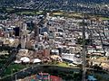
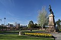
Gallery
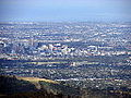
Aerial view of the Adelaide city centre looking south-east, 2005.
A statue of Queen Victoria has stood in the geometric centre of both Victoria Square and "the square mile" since 1894.
↑ The area of the park lands quoted is based, in the absence of an official boundary between the City and North Adelaide, on an east–west line past the front entrance of Adelaide Oval.
↑ Elgar, Frederic (1863). Handbook to the Colony of South Australia. London: "Australian and New Zealand Gazette" Office. p.3. Retrieved 8 December 2014. ... principal north and south streets (from 99 to 132 feet wide) being nearly one mile in length, and the east and west streets (from 66 to 132 feet wide) from a mile and a quarter to a mile and three-quarters.
↑ Margaret Anderson (31 December 2013). "Light's Plan of Adelaide 1837". adelaidia.sa.gov.au. History SA. Archived from the original on 18 August 2017. Retrieved 5 May 2018. The page contains a copy of one of the two surviving original plans drawn in 1837. Quote: "It is a watercolour and ink plan, drawn by 16-year-old draughtsman Robert George Thomas to instructions from Light. ... The streets were named by a Street Naming Committee that met on 23 May 1837, indicating that this plan must have been completed after that date."
Spence, Catherine Helen; Beams, Maryan (2006). Susan Magarey; Barbara Wall; Maryan Beams; Mary Lyons (eds.). Ever yours, C.H. Spence: Catherine Helen Spence's An autobiography (1825-1910), Diary (1894) and Some correspondence (1894-1910). Wakefield Press. ISBN978-1-86254-656-1.
This page is based on this Wikipedia article Text is available under the CC BY-SA 4.0 license; additional terms may apply. Images, videos and audio are available under their respective licenses.