Administrative divisions of Arkhangelsk Oblast

Last updated
Arkhangelsk Oblast, Russia Flag of Arkhangelsk Oblast.svg
Administrative center: Arkhangelsk
As of 2013: [1]
# of districts
(районы)
21
# of cities and towns
(города)
13
# of urban-type settlements
(посёлки городского типа)
14
# of selsovets
(сельсоветы)
239
As of 2002: [2]
# of rural localities
(сельские населённые пункты)
3,914
# of uninhabited rural localities
(сельские населённые пункты без населения)
547

Within the framework of administrative divisions, Arkhangelsk Oblast is divided into six cities and towns of oblast significance, twenty-one districts, and two island territories (Franz Joseph Land and Victoria Island). Besides, Mirny is a town under the federal government management.

Contents

In terms of the area, the biggest administrative districts are Novaya Zemlya (90,650 square kilometres (35,000 sq mi)) and Mezensky District (34,400 square kilometres (13,300 sq mi)). The smallest one is Solovetsky District.

In terms of the population, the biggest administrative district is Velsky District (61,819 in 2002), the smallest ones are Solovetsky District (968), Novaya Zemlya (2716), and Leshukonsky District (10,708). [3]

Administrative and municipal divisions

Administrative districts of Arkhangelsk Oblast. The numbers denote the following districts: 1- Onezhsky, 2 - Primorsky, 3 - Mezensky, 4 - Leshukonsky, 5 - Pinezhsky, 6 - Kholmogorsky, 7 - Plesetsky, 8 - Vinogradovsky, 9 - Verkhnetoyemsky, 10 - Kargopolsky, 11 - Nyandomsky, 12 - Shenkursky, 13 - Konoshsky, 14 - Velsky, 15 - Ustyansky, 16 - Krasnoborsky, 17 - Lensky, 18 - Kotlassky, 19 - Vilegodsky. Solovetsky District is shown as an unnumbered island. Novaya Zemlya District is not shown. Arh.location.map.numbered.png
Administrative districts of Arkhangelsk Oblast. The numbers denote the following districts: 1- Onezhsky, 2 - Primorsky, 3 - Mezensky, 4 - Leshukonsky, 5 - Pinezhsky, 6 - Kholmogorsky, 7 - Plesetsky, 8 - Vinogradovsky, 9 - Verkhnetoyemsky, 10 - Kargopolsky, 11 - Nyandomsky, 12 - Shenkursky, 13 - Konoshsky, 14 - Velsky, 15 - Ustyansky, 16 - Krasnoborsky, 17 - Lensky, 18 - Kotlassky, 19 - Vilegodsky. Solovetsky District is shown as an unnumbered island. Novaya Zemlya District is not shown.
DivisionStructure OKATO OKTMO Urban-type settlement/
island territory/district-level town*
Rural
(selsovet)
AdministrativeMunicipal
Mirny (Мирный)city (ZATO)urban okrug11 52511 725
Arkhangelsk (Архангельск)cityurban okrug11 40111 701
Isakogorsky (Исакогорский)(under Arkhangelsk )11 401
Lomonosovsky (Ломоносовский)(under Arkhangelsk )11 401
Maymaksansky (Маймаксанский)(under Arkhangelsk )11 401
Mayskaya Gorka (Майская Горка)(under Arkhangelsk )11 401
Oktyabrsky (Октябрьский)(under Arkhangelsk )11 401
Severny (Северный)(under Arkhangelsk )11 401
Solombalsky (Соломбальский)(under Arkhangelsk )11 401
Tsiglomensky (Цигломенский)(under Arkhangelsk )11 401
Varavino-Faktoriya (Варавино-Фактория)(under Arkhangelsk )11 401
Koryazhma (Коряжма)cityurban okrug11 40811 708
Kotlas (Котлас)cityurban okrug11 41011 710
Novodvinsk (Новодвинск)cityurban okrug11 41511 715
Onega (Онега)city(under Onezhsky )11 42011 646
Severodvinsk (Северодвинск)cityurban okrug11 43011 730
Kargopolsky (Каргопольский)district11 21811 61812
Kholmogorsky (Холмогорский)district11 25611 65618
Konoshsky (Коношский)district11 22211 62210
Kotlassky (Котласский)district11 22711 62712
Krasnoborsky (Красноборский)district11 23011 63010
Lensky (Ленский)district11 23511 6359
Leshukonsky (Лешуконский)district11 23811 6387
Mezensky (Мезенский)district11 24211 642
  • Mezen (Мезень) town*
12
Novaya Zemlya (Новая Земля)districturban okrug11 24311 712
Nyandomsky (Няндомский)district11 24411 6448
Onezhsky (Онежский)district11 24611 64613
Pinezhsky (Пинежский)district11 24811 64817
Plesetsky (Плесецкий)district11 25011 65011
Primorsky (Приморский)district11 25211 65217
Shenkursky (Шенкурский)district11 25811 65812
Solovetsky (Соловецкий)district(under Primorsky )11 25311 652
Ustyansky (Устьянский)district11 25411 65417
Velsky (Вельский)district11 20511 60520
Verkhnetoyemsky (Верхнетоемский)district11 20811 60814
Vilegodsky (Вилегодский)district11 21111 6116
Vinogradovsky (Виноградовский)district11 21411 61413
Nenets (Не́нецкий)autonomous okrug see list of divisions

Differences with municipal divisions

Most of the administrative districts of Arkhangelsk Oblast are municipally incorporated as municipal districts, and most of the cities and towns of oblast significance are municipally incorporated as urban okrugs. There are, however, several exceptions, [4]

History

December 29 [ O.S. December 18], 1708 Tsar Peter the Great issued an edict which established seven governorates. [5] [6] The description of the borders of the governorates was not given; instead, their area was defined as a set of towns and the lands adjacent to those towns. In the present area of Arkhangelsk oblast, two of the governorates—Archangelgorod Governorate and Ingermanland Governorate—were located. The governorates were subdivided into uyezds, and uyezds into volosts.

The centers of the following uyezds of Archangelgorod Governorate were located in the present-day area of Arkhangelsk Oblast,

Pustozyorsky Uyezd (with the center in Pustozerskoy) was located in what is now Nenets Autonomous Okrug.

On June 9 [ O.S. May 29], 1719, the governorate was divided into provinces: Archangelgorod, Vologda, Galich, and Ustyug. [6] Simultaneously, Yarensky Uyezd with the administrative center of Yarensk was moved from Siberia Governorate to Archangelgorod Governorate. [7] The uyezds were transformed into districts, however, in 1727 the districts were transformed back into uyezds. On February 5 [ O.S. January 25], 1780, Archangelgorod Governorate was transformed into Vologda Viceroyalty. [6] In 1796, the viceroyalty was split into Arkhangelsk and Vologda Governorates, the latter one including the areas currently in the south-east of the Oblast. In 1918, these areas were split off from the Vologda Governorate and moved to the newly established Northern Dvina Governorate. The administrative center of the governorate was Veliky Ustyug.

The southwestern part of Arkhangelsk Oblast in 1708 became Kargopolsky Uyezd of Ingermanland Governorate (from 1710, Saint Petersburg Governorate), with the seat in the town of Kargopol. In 1727, it moved to the newly established Novgorod Governorate. After a number of administrative reforms, in 1801 it ended up as one of the four uyezds of the newly established Olonets Governorate.

In 1924, the uyezds of Northern Dvina Governorate were abolished in favor of the new divisions, the districts (raions). Arkhangelsk and Olonets Governorates retained the uyezd division till 1929. On July 15, 1929 the uyezds in these two governorates were abolished, and all areas which currently belong to Arkhangelsk Oblast, together with other areas, merged into the Northern Krai. The krai consisted of the Komi-Zyryan Autonomous Oblast, a number of islands in the Arctic Ocean, as well as five administrative districts ( okrugs ), [8] [9]

All these okrugs (except for the Nenets Okrug) were divided into districts. In 1930, the okrugs were abolished, and the districts became directly subordinate to the Northern Krai. In 1936, according to the new Soviet Constitution, the Northern Krai was transformed into Northern Oblast. In 1937, Northern Oblast was split into Arkhangelsk Oblast and Vologda Oblast. In 1941, three districts of Arkhangelsk Oblast—Oparinsky, Lalsky, and Podosinovsky—were transferred to Kirov Oblast. During the attempted administrative reform in 1963, districts were subdivided into urban and rural districts. The reform was abandoned in 1965, and the division into districts was restored. On March 23, 1987, Solovetsky District was established, [8] and in 2001, Novaya Zemlya obtained the district status.

Abolished districts

After 1929 (with the exception of the aborted reform of 1963–1965) borders between the districts sometimes were modified, and as a result some of the districts in the area currently belonging to Arkhangelsk Oblast were abolished, [8]

Related Research Articles

<span class="mw-page-title-main">Pinega</span> Rural locality in Arkhangelsk Oblast, Russia

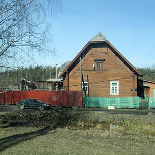
Pinega is a rural locality, formerly a town, in Pinezhsky District of Arkhangelsk Oblast, Russia, located on the right bank of the Pinega River. It serves as the administrative center of Pinezhsky Selsoviet, one of the seventeen selsoviets into which the district is administratively divided. Municipally, it is the administrative center of Pinezhskoye Rural Settlement, one of the fifteen rural settlements in the district. Population: 3,225 (2010 Census); 3,763 (2002 Census); 4,401 (1989 Census)..

Administratively, Vologda Oblast is divided into four cities and towns of oblast significance and twenty-six districts.

<span class="mw-page-title-main">Plesetsky District</span> District in Arkhangelsk Oblast, Russia

Plesetsky District is an administrative district (raion) one of the twenty-one in Arkhangelsk Oblast, Russia. As a municipal division, it is incorporated as Plesetsky Municipal District. It is located in the west of the oblast and borders with Primorsky District in the north, Kholmogorsky District in the northeast, the territories of the town of oblast significance of Mirny and Vinogradovsky District in the east, Shenkursky District in the southeast, Nyandomsky and Kargopolsky Districts in the south, Pudozhsky District of the Republic of Karelia in the west, and with Onezhsky District in the northwest. The area of the district is 27,500 square kilometers (10,600 sq mi). Its administrative center is the urban locality of Plesetsk. Population: 49,077 (2010 Census); 58,257 (2002 Census); 83,357 (1989 Census). The population of Plesetsk accounts for 22.5% of the district's total population.

<span class="mw-page-title-main">Kholmogorsky District</span> District in Arkhangelsk Oblast, Russia

Kholmogorsky District is an administrative district (raion), one of the twenty-one in Arkhangelsk Oblast, Russia. Municipally, it is incorporated as Kholmogorsky Municipal District. It is located in the center of the oblast and borders with Pinezhsky District in the east, Vinogradovsky District in the southeast, the territory of the town of oblast significance of Mirny in the south, Plesetsky District in the southwest, and with Primorsky District in the northwest. The area of the district is 16,827 square kilometers (6,497 sq mi). Its administrative center is the rural locality of Kholmogory. District's population: 25,061 (2010 Census); 30,797 (2002 Census); 35,891 (1989 Census). The population of Kholmogory accounts for 16.6% of the district's total population.

<span class="mw-page-title-main">Konoshsky District</span> District in Arkhangelsk Oblast, Russia

Konoshsky District is an administrative district (raion), one of the twenty-one in Arkhangelsk Oblast, Russia. As a municipal division, it is incorporated as Konoshsky Municipal District. It is located in the southwest of the oblast and borders with Nyandomsky District in the north, Velsky District in the east, Verkhovazhsky, Vozhegodsky, and Kirillovsky Districts of Vologda Oblast in the south, and with Kargopolsky District in the west. The area of the district is 8,500 square kilometers (3,300 sq mi). Its administrative center is the urban locality of Konosha. Population: 26,106 (2010 Census); 31,067 (2002 Census); 42,136 (1989 Census). The population of Konosha accounts for 47.6% of the district's total population.

<span class="mw-page-title-main">Lensky District, Arkhangelsk Oblast</span> District in Arkhangelsk Oblast, Russia

Lensky District is an administrative district (raion), one of the twenty-one in Arkhangelsk Oblast, Russia. As a municipal division, it is incorporated as Lensky Municipal District. It is located in the southeast of the oblast and borders with Udorsky District of the Komi Republic in the north, Syktyvdinsky, Ust-Vymsky, and Sysolsky Districts, also of the Komi Republic, in the east, Vilegodsky District in the south, and with Kotlassky and Krasnoborsky Districts in the west. The area of the district is 10,700 square kilometers (4,100 sq mi). Its administrative center is the rural locality of Yarensk. Population: 13,362 (2010 Census); 16,071 (2002 Census); 20,488 (1989 Census). The population of Yarensk accounts for 27.4% of the district's total population.

<span class="mw-page-title-main">Solovetsky District</span> District in Arkhangelsk Oblast, Russia

Solovetsky District is an administrative district (raion), one of the twenty-one in Arkhangelsk Oblast, Russia. It is located on the Solovetsky Islands archipelago in the White Sea. Its administrative center is the rural locality of Solovetsky. District's population: 861 (2010 Census); 968 (2002 Census); 1,317 (1989 Census).

<span class="mw-page-title-main">Leshukonsky District</span> District in Arkhangelsk Oblast, Russia

Leshukonsky District is an administrative district (raion), one of the twenty-one in Arkhangelsk Oblast, Russia. Municipally, it is incorporated as Leshukonsky Municipal District. It is located in the northeast of the oblast and borders with Mezensky District in the north, Ust-Tsilemsky District of the Komi Republic in the east, Udorsky District of the Komi Republic in the south, and with Pinezhsky District in the west. Its administrative center is the rural locality of Leshukonskoye. District's population: 7,979 (2010 Census); 10,708 (2002 Census); 15,488 (1989 Census). The population of Leshukonskoye accounts for 55.2% of the district's population.

<span class="mw-page-title-main">Ustyansky District</span> District in Arkhangelsk Oblast, Russia

Ustyansky District is an administrative district (raion), one of the twenty-one in Arkhangelsk Oblast, Russia. As a municipal division, it is incorporated as Ustyansky Municipal District. It is located in the south of the oblast and borders with Verkhnetoyemsky District in the northeast, Krasnoborsky and Kotlassky Districts in the east, Velikoustyugsky, Nyuksensky, Tarnogsky, and Verkhovazhsky Districts, all of Vologda Oblast, in the south, Velsky District in the west, and with Shenkursky District in the northwest. The area of the district is 10,700 square kilometers (4,100 sq mi). Its administrative center is the urban locality of Oktyabrsky. Population: 30,581 (2010 Census); 37,131 (2002 Census); 45,352 (1989 Census). The population of Oktyabrsky accounts for 30.4% of the district's total population.

<span class="mw-page-title-main">Krasnoborsky District</span> District in Arkhangelsk Oblast, Russia

Krasnoborsky District is an administrative district (raion), one of the twenty-one in Arkhangelsk Oblast, Russia. Municipally, it is incorporated as Krasnoborsky Municipal District. It is located in the southeast of the oblast and borders with Verkhnetoyemsky District in the north, Udorsky District of the Komi Republic in the northeast, Lensky District in the east, Kotlassky District in the south, and with Ustyansky District in the west. Its administrative center is the rural locality of Krasnoborsk. District's population: 13,815 (2010 Census); 17,144 (2002 Census); 20,491 (1989 Census). The population of Krasnoborsk accounts for 34.5% of the district's total population.

<span class="mw-page-title-main">Vilegodsky District</span> District in Arkhangelsk Oblast, Russia

Vilegodsky District is an administrative district (raion), one of the twenty-one in Arkhangelsk Oblast, Russia. Municipally, it is incorporated as Vilegodsky Municipal District. It is located in the southeast of the oblast and borders with Lensky District in the north, Sysolsky and Priluzsky Districts of the Komi Republic in the east, Luzsky District of Kirov Oblast in the south, and with Kotlassky District in the west. Its administrative center is the rural locality of Ilyinsko-Podomskoye. District's population: 11,158 (2010 Census); 13,241 (2002 Census); 16,616 (1989 Census). The population of Ilyinsko-Podomskoye accounts for 33.0% of the district's total population.

<span class="mw-page-title-main">Velsky District</span> District in Arkhangelsk Oblast, Russia

Velsky District is an administrative district (raion), one of the twenty-one in Arkhangelsk Oblast, Russia. As a municipal division, it is incorporated as Velsky Municipal District. It is located in the south of the oblast and borders with Shenkursky District in the north, Ustyansky District in the east, Verkhovazhsky District of Vologda Oblast in the south, Konoshsky District in the west, and with Nyandomsky District in the northwest. The area of the district is 10,060 square kilometers (3,880 sq mi). Its administrative center is the town of Velsk. Population: 54,792 (2010 Census); 61,819 (2002 Census); 71,474 (1989 Census). The population of Velsk accounts for 43.6% of the district's total population.

<span class="mw-page-title-main">Shenkursky District</span> District in Arkhangelsk Oblast, Russia

Shenkursky District is an administrative district (raion), one of the twenty-one in Arkhangelsk Oblast, Russia. As a municipal division, it is incorporated as Shenkursky Municipal District. It is located in the south of the oblast and borders with Vinogradovsky District in the north, Verkhnetoyemsky District in the east, Ustyansky District in the southeast, Velsky District in the south, Nyandomsky District in the west, and with Plesetsky District in the northwest. The area of the district is 11,298 square kilometers (4,362 sq mi). Its administrative center is the town of Shenkursk. Population: 15,196 (2010 Census); 18,680 (2002 Census); 22,597 (1989 Census). The population of Shenkursk accounts for 37.5% of the district's total population.

<span class="mw-page-title-main">Vinogradovsky District</span> District in Arkhangelsk Oblast, Russia

Vinogradovsky District is an administrative district (raion), one of the twenty-one in Arkhangelsk Oblast, Russia. As a municipal division, it is incorporated as Vinogradovsky Municipal District. It is located in the center of the oblast and borders with Pinezhsky District in the northeast, Verkhnetoyemsky District in the southeast, Shenkursky District in the south, Plesetsky District in the southwest, the town of oblast significance of Mirny in the west, and with Kholmogorsky District in the northwest. The area of the district is 12,600 square kilometers (4,900 sq mi). Its administrative center is the urban locality of Bereznik. Population: 16,753 (2010 Census); 20,862 (2002 Census); 24,834 (1989 Census). The population of Bereznik accounts for 35.9% of the district's total population.

<span class="mw-page-title-main">Pinezhsky District</span> District in Arkhangelsk Oblast, Russia

Pinezhsky District is an administrative district (raion), one of the twenty-one in Arkhangelsk Oblast, Russia. Municipally, it is incorporated as Pinezhsky Municipal District. It is located in the northeast of the oblast and borders with Mezensky District in the north, Leshukonsky District and Udorsky District of the Komi Republic in the east, Verkhnetoyemsky District in the south, Vinogradovsky District in the southwest, Kholmogorsky District in the west, and with Primorsky District in the northwest. Its administrative center is the rural locality of Karpogory. District's population: 26,978 (2010 Census); 33,516 (2002 Census); 40,486 (1989 Census). The population of Karpogory accounts for 16.5% of the district's total population.

<span class="mw-page-title-main">Mezensky District</span> District in Arkhangelsk Oblast, Russia

Mezensky District is an administrative district (raion), one of the twenty-one in Arkhangelsk Oblast, Russia. As a municipal division, it is incorporated as Mezensky Municipal District. It is located in the northeast of the oblast and borders with Nenets Autonomous Okrug in the northeast, Ust-Tsilemsky District of the Komi Republic in the east, Leshukonsky and Pinezhsky Districts in the south, and with Primorsky District in the southwest. From the north, the district borders the White Sea. The area of the district is 34,400 square kilometers (13,300 sq mi). Its administrative center is the town of Mezen. Population: 10,330 (2010 Census); 13,124 (2002 Census); 17,796 (1989 Census). The population of Mezen accounts for 34.6% of the total district's population.

<span class="mw-page-title-main">Leshukonskoye</span> Selo in Arkhangelsk Oblast, Russia

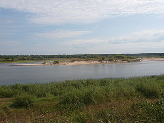
Leshukonskoye is a rural locality and the administrative center of Leshukonsky District of Arkhangelsk Oblast, Russia, located on the left bank of the Vashka River. It also serves as the administrative center of Leshukonsky Selsoviet, one of the seven selsoviets into which the district is administratively divided. Municipally, it is the administrative center of Leshukonskoye Rural Settlement. Population: 4,406 (2010 Census); 5,003 (2002 Census); 6,199 (1989 Census).

<span class="mw-page-title-main">Onezhsky District</span> District in Arkhangelsk Oblast, Russia

Onezhsky District is an administrative district (raion), one of the twenty-one in Arkhangelsk Oblast, Russia. As a municipal division, it is incorporated as Onezhsky Municipal District. It is located in the northwest of the oblast and borders with Primorsky District in the northeast, Plesetsky District in the southeast, Pudozhsky, Medvezhyegorsky, and Segezhsky Districts of the Republic of Karelia in the southwest, and with Belomorsky District of the Republic of Karelia in the west. In the north, the district is washed by the White Sea. The area of the district is 23,740 square kilometers (9,170 sq mi). Its administrative center is the town of Onega. Population: 14,017 (2010 Census); 16,791 (2002 Census); 22,269 (1989 Census).

<span class="mw-page-title-main">Primorsky District, Arkhangelsk Oblast</span> District in Arkhangelsk Oblast, Russia

Primorsky District is an administrative district (raion), one of the twenty-one in Arkhangelsk Oblast, Russia. As a municipal division, it is incorporated as Primorsky Municipal District, and also includes Solovetsky Islands in the White Sea and Franz Josef Land and Victoria Island in the Arctic Ocean. It is located in the north of the oblast and borders with Mezensky District in the northeast, Pinezhsky District in the east, Kholmogorsky District in the southeast, Plesetsky District in the south, and with Onezhsky District in the south. From the north, the district is washed by the White Sea. The area of the district is 46,100 square kilometers (17,800 sq mi). Its administrative center is the city of Arkhangelsk. Population: 25,466 (2010 Census); 29,365 (2002 Census); 31,813 (1989 Census).

References

Notes

  1. Государственный комитет Российской Федерации по статистике. Комитет Российской Федерации по стандартизации, метрологии и сертификации. №ОК 019-95 1 января 1997 г. «Общероссийский классификатор объектов административно-территориального деления. Код 11», в ред. изменения №278/2015 от 1 января 2016 г.. (State Statistics Committee of the Russian Federation. Committee of the Russian Federation on Standardization, Metrology, and Certification. #OK 019-95 January 1, 1997 Russian Classification of Objects of Administrative Division (OKATO). Code 11 , as amended by the Amendment #278/2015 of January 1, 2016. ).
  2. Results of the 2002 Russian Population CensusTerritory, number of districts, inhabited localities, and rural administrations of the Russian Federation by federal subject Archived September 28, 2011, at the Wayback Machine
  3. Russian Federal State Statistics Service (May 21, 2004). Численность населения России, субъектов Российской Федерации в составе федеральных округов, районов, городских поселений, сельских населённых пунктов – районных центров и сельских населённых пунктов с населением 3 тысячи и более человек [Population of Russia, Its Federal Districts, Federal Subjects, Districts, Urban Localities, Rural Localities—Administrative Centers, and Rural Localities with Population of Over 3,000](XLS). Всероссийская перепись населения 2002 года [All-Russia Population Census of 2002] (in Russian).
  4. Архангельское областное Собрание депутатов. Областной закон №258-внеоч.-ОЗ от 23 сентября 2004 г. «О статусе и границах территорий муниципальных образований в Архангельской области», в ред. Областного закона №224-13-ОЗ от 16 декабря 2014 г. «Об упразднении отдельных населённых пунктов Соловецкого района Архангельской области и о внесении изменения в статью 46 Областного закона "О статусе и границах территорий муниципальных образований в Архангельской области"». Вступил в силу со дня официального опубликования. Опубликован: "Волна", №38, 8 октября 2004 г. (Arkhangelsk Oblast Council of Deputies. Oblast Law #258-vneoch.-OZ of September 23, 2004 On the Status and Borders of the Territories of the Municipal Formations in Arkhangelsk Oblast, as amended by the Oblast Law #224-13-OZ of December 16, 2014 On Abolishing Several Inhabited Localities in Solovetsky District of Arkhangelsk Oblast and on Amending Article 46 of the Oblast Law "On the Status and Borders of the Territories of the Municipal Formations in Arkhangelsk Oblast". Effective as of the day of the official publication.).
  5. Указ об учреждении губерний и о росписании к ним городов (in Russian)
  6. 1 2 3 Архивный отдел Администрации Мурманской области. Государственный Архив Мурманской области. (1995). Административно-территориальное деление Мурманской области (1920-1993 гг.). Справочник. Мурманск: Мурманское издательско-полиграфическое предприятие "Север". pp. 19–20.
  7. Лукошников, В. А. (March 22, 2006). Яренский уезд. Маяк (in Russian) (22).
  8. 1 2 3 "Административно-территориальное деление Архангельской губернии в XVIII-XX вв" (in Russian). Архивы России. 2000. Archived from the original on July 24, 2011. Retrieved August 25, 2011.
  9. Постановление Президиума ВЦИК от 15 июля 1929 года о составе округов и районов Северного Края и их центрах (in Russian). consultant.ru. Archived from the original on January 4, 2016. Retrieved August 18, 2011.

Sources