Related Research Articles

The River Clwyd is a river in Wales that rises in the Clocaenog Forest 5 miles northwest of Corwen. Its total length is 35 miles.

The River Conwy is a river in north Wales. From its source to its discharge in Conwy Bay it is 55 kilometres (34 mi) long and drains an area of 678 square km. "Conwy" was formerly Anglicised as "Conway."

The River Towy is one of the longest rivers flowing entirely within Wales. Its total length is 120 km (75 mi). It is noted for its sea trout and salmon fishing.

The River Teifi in Wales forms the boundary for most of its length between the counties of Ceredigion and Carmarthenshire, and for the final 3 miles (4.8 km) of its total length of 76 miles (122 km), the boundary between Ceredigion and Pembrokeshire. Its estuary is northwest of Cardigan. Teifi has formerly been anglicised as "Tivy".
The Afon Ogwen is a river in north-west Wales draining from some of the greatest peaks in Snowdonia before discharging to the sea on the eastern side of Bangor, Gwynedd.

The River Dwyryd is a river in Gwynedd, Wales which flows principally westwards; draining to the sea into Tremadog Bay, south of Porthmadog.

Llyn Cwellyn is a reservoir in North Wales which supplies drinking water to parts of Gwynedd and Anglesey. It lies on the Afon Gwyrfai in Nant y Betws between Moel Eilio and Mynydd Mawr in the northern part of Snowdonia National Park. It has an area of 215 acres (0.87 km2), and is over 120 ft (37 m) deep. At the southern end is the small village of Rhyd Ddu.

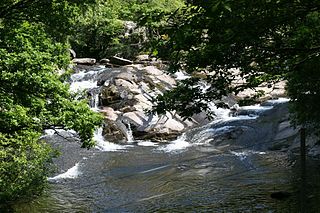
The Afon Glaslyn is a river in Gwynedd, north-west Wales. While not of great significance in terms of its length, it is one of Gwynedd's primary rivers, and has greatly influenced the landscape in which it flows.

The Black Mountain is a mountain range in South and West Wales, straddling the county boundary between Carmarthenshire and Brecknockshire and forming the westernmost range of the Brecon Beacons National Park. Its highest point is Fan Brycheiniog at 802 metres or 2,631 ft. The Black Mountain also forms a part of the Fforest Fawr Geopark.

The River Dysynni is a river in mid Wales. Its source is the Tal-y-llyn Lake just south of the Cadair Idris massif and its mouth is in the Cardigan Bay area of the Irish Sea to the north of Tywyn. It measures about 16 mi (26 km) in length.

The Afon Tarell is a river in Powys, Wales, which rises to the west of the Brecon Beacons in Brecon Beacons National Park and flows north, then north-east, for 12 miles (20 km) into the River Usk.

The Afon Sawdde is a river in the county of Carmarthenshire, Wales. For most of its course it flows through the Brecon Beacons National Park and Fforest Fawr Geopark.

Afon Braint is a small tidal river on Anglesey, North Wales. There is a series of stepping stones near to the village of Dwyran, and a Grade II bridge near Penmynydd. Until recently, there was an electoral ward named after the river.

The Afon Dulas is a river in Powys, Wales. It is a headwater tributary of the River Severn, which it joins at Llanidloes opposite the confluence with the Afon Clywedog. Its principal tributary is the Afon Brochan. The total length of the Dulas and Brochan is 19.6 km. Other tributaries include Nant Cydros, the Rhydyclwydau Brook and Nant Gynwydd.
The Afon Ysgethin is a short river in Gwynedd, Wales. Flowing entirely within Snowdonia National Park it rises beneath the peaks of Y Llethr and Diffwys within the Rhinogs mountain range and runs in a generally ESE direction towards Cardigan Bay. Headwater streams flow into Llyn Bodlyn reservoir and a small upper lake, Llyn Dulyn. The river emerging from the reservoir dam is crossed by an historic track at Pont Scethin. This old stone arch bridge was used historically by packhorses and drovers moving between Harlech and London. A further 3km downstream it enters a narrower wooded valley and is crossed by Pont Fadog. There are two further crossings at the village of Tal-y-bont; by the A496 road and by the Cambrian Coast railway. After another 1km it enters the sea.
The Afon Soch is a short river on the Llŷn peninsula, Gwynedd, Wales. It arises to the north of the village of Sarn Meyllteyrn, through which it then flows, turning southeast towards Botwnnog. Beyond Botwnnog it is joined by its main left-bank tributary, the Afon Horon, which rises to the east of Carn Fadryn. Their combined flow approaches the coast at Porth Neigwl but instead the river turns sharply northwards at Llanengan and curves around east to Abersoch where it enters the sea. A short section of the Soch valley is followed by the Wales Coast Path where it takes a route inland of Porth Neigwl. Both the Soch and the Horon are misfit streams within valleys that were formed by glacial meltwater. The river name is reckoned to be of Irish origin, the old Irish word 'socc' meaning a sow. There are a number of other Irish names in Llŷn.
The Afon Ffraw is a short river on the Isle of Anglesey, Wales. It arises at Llyn Coron and flows southwest for two miles along the northwestern margin of Twyn Aberffraw via the village of Aberffraw to Aberffraw Bay on the island's west coast. The river is tidal to a point just northeast of Aberffraw and is accompanied by the Wales Coast Path and Isle of Anglesey Coastal Path. Llyn Coron is fed by the Afon Gwna which rises near to Llangefni in the centre of Anglesey. The flow of the Ffraw is bolstered by the left-bank tributary, the Afon Frechwen and a larger, though unnamed right-bank tributary which rises near Gwalchmai. Pont Aberffraw is a bridge spanning the river constructed as a single stone arch in 1731. When the A4080 main coastal road was diverted onto a new line, the old bridge closed to traffic.
The Afon Erch is a short river on the Llŷn peninsula, Gwynedd, Wales. It arises near the village of Llanaelhaearn, flowing south and southwest towards the hamlet of Llwyndyrys where it turns abruptly eastwards and curves around to the south, passing to the east of Y Ffor at Rhyd-y-gwystl. It continues towarin a SSW direction towards Abererch where despite the village name, it does not enter the sea but flows west parallel to the coast for 1 mile to Pwllheli. The Afon Rhyd-hir joins the Afon Erch within the tidal basin of Pwllheli Harbour. Its headwaters gather to the south of Llithfaen and flow south past Llannor to approach Pwllheli from the west. It is joined by the Afon Penrhos immediately west of the town, having originated around the extensive bog of Cors Geirch, a national nature reserve. Parts of the courses of each of these rivers occupy valleys that were formed by glacial meltwater. The uppermost Penrhos is a misfit stream within its valley.
References
- ↑ 254 Lleyn Peninsula East[Pen Llyn Ardal Ddwyreiniol] (Map) (A2 ed.). 1:25,000. Explorer. Ordnance Survey. 2005. ISBN 0319236471.
- ↑ Owen, Hywel Wyn; Morgan, Richard (2007). Dictionary of the Place-names of Wales (First ed.). Llandyssul, Ceredigion: Gomer Press. p. 184. ISBN 9781843239017.
Coordinates: 53°06′24″N4°18′39″W / 53.10653°N 4.31088°W
| | This Gwynedd location article is a stub. You can help Wikipedia by expanding it. |