
Powys is a county and preserved county in Wales. It borders Gwynedd, Denbighshire, and Wrexham to the north; the English ceremonial counties of Shropshire and Herefordshire to the east; Monmouthshire, Blaenau Gwent, Merthyr Tydfil, Caerphilly, Rhondda Cynon Taf, and Neath Port Talbot to the south; and Carmarthenshire and Ceredigion to the west. The largest settlement is Newtown, and the administrative centre is Llandrindod Wells.
Llandrinio is a small village and community in Montgomeryshire, Powys, Wales, close to the Wales-England border. It is situated on the B4393 road which travels from the village of Ford, Shropshire to Lake Vyrnwy. The community, Llandrinio and Arddleen includes Arddlin and a small part of Four Crosses, Powys.

Lake Vyrnwy is a reservoir in Powys, Wales, built in the 1880s for Liverpool Corporation Waterworks to supply Liverpool with fresh water. It flooded the head of the Vyrnwy valley and submerged the village of Llanwddyn.

Afon Rheidol is a river in Ceredigion, Wales, 19 miles (31 km) in length. The source is Plynlimon. Receiving an average annual rainfall of 40 inches (1.02 m), Plynlimon is also the source of both the Wye and the Severn.
The River Rhaeadr is a river in Wales.

The River Vyrnwy flows through northern Powys, Wales, and Shropshire, England. The name derives from Severn, the river of which it is a tributary.

Sycharth was a motte and bailey castle near Llansilin, Powys, Wales. Until 1996 Sycharth was in the historic county of Denbighshire, but was then transferred to the Shire area of Montgomeryshire within Powys. Sycharth was the birthplace of Owain Glyndŵr.

Llangynog is a village and community at the confluence of the Afon Eirth and the Afon Tanat at the foot of the Berwyn range in north Powys, Wales.

The Afon Twymyn is a river in Powys, Mid Wales.

The River Carno is a river in Powys, mid Wales, and a tributary of the River Severn.

Mechain was a medieval cantref in the Kingdom of Powys. This cantref has also been referred to as Y Fyrnwy (Vyrnwy). Mechain may owe its name to the River Cain which flows through it on its way to join the River Vyrnwy; 'Me' or 'Mach' may signify meadows or plain, in which case Mechain would mean "Meadows of the Cain". It corresponds to the later hundred of Llanfyllin.

Cyrniau Nod is a mountain summit in north east Wales. It is a former Marilyn, the Marilyn summit now being the nearby Foel Cedig. Its summit has the Snowdonia National Park boundary running through it. A number of rivers and streams rise from near the mountain including Afon Tanat, Afon Cedig and Nant Ystrad-y-Groes.

The Afon Iwrch is a river near Llanrhaeadr-ym-Mochnant in Clwyd, Wales. It is a tributary of the River Tanat and is 8.9 miles (14.4 km) in length. Its headwaters lie on the eastern slopes of Cadair Berwyn, the highest peak of the Berwyn range, and the river flows broadly southeastwards to join the River Tanat, itself a tributary of the River Vyrnwy.
The River Ithon is a major left-bank tributary of the River Wye in Powys, mid Wales. It rises in the broad saddle between the western end of Kerry Hill and the hill of Glog to its west and flows initially southwards to Llanbadarn Fynydd. It then takes a twisting route south via the villages of Llanbister, Llanddewi Ystradenny and Penybont before turning southwest, then doubling back northwards towards Crossgates. From here it resumes a southwesterly course, flowing past Llandrindod Wells and the site of Cefnllys Castle to a confluence with the Wye, 1 mile to the south of Newbridge-on-Wye.
The Afon Llafar is a small river in North Wales which, rising on the eastern slopes of Arenig Fawr, flows south-east through the hamlet of Parc and into Bala Lake. It is within the Dee catchment.

Duhonw is a rural community in Powys, Wales, to the south of Builth Wells, in the historic county of Breconshire. Covering an area of 4,376 hectares (16.90 sq mi) and including scattered farms and dwellings, it is bounded to its north by the Afon Irfon, to its south by Mynydd Epynt and Banc y Celyn (472m) and to its east the rivers Duhonw and Wye. Llangammarch Wells' is to its west.

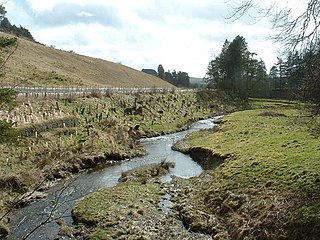
The River Banwy is a river about 19 miles (31 km) long in Powys, Wales. It is a tributary of the River Vyrnwy.

The River Cain is a river in north Powys which flows into the River Vyrnwy.

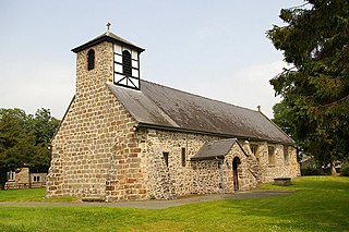
Pen-y-Bont-Fawr is a small village and community in Montgomeryshire, Powys, Wales located in the Tanat valley. In the 2011 UK Census it had a population of 440 with 58% born in England and 39% in Wales.

The Mule is a short river in Powys, mid Wales, and a tributary of the River Severn. It rises at Black Gate near the west end of Kerry Hill and is joined by a number of streams, principal amongst which is the Nant Meheli, east of Kerry. Initially flowing northeast it turns to flow east at Kerry and then northwest, entering a narrow section of valley near Llanmerewig before joining the Severn at Abermule.
