Brownfield refers to land that is abandoned or underutilized due to pollution from industrial use. The specific definition of brownfield land varies and is decided by policy makers and/or land developers within different countries. The main difference in definitions of whether a piece of land is considered a brownfield or not depends on the presence or absence of pollution. Overall, brownfield land is a site previously developed for industrial or commercial purposes and thus requires further development before reuse.

Munisport Landfill is a closed landfill located in North Miami, Florida adjacent to a low-income community, a regional campus of Florida International University, Oleta River State Park, and estuarine Biscayne Bay.
The 120-acre (0.49 km2) Pfohl Brothers Landfill was a privately owned and operated landfill in Cheektowaga, New York. The landfill accepted municipal and industrial wastes from 1932 until 1971. It is located 1/2 mile east of the Buffalo Niagara International Airport and sits on the north bank of Ellicott Creek. It lies west of Transit Road and south of the New York State Thruway near Thruway Exit 49. It is bisected by Aero Drive.
The Laurel Park, Inc. site, also known as Hunters Mountain Dump, or Murtha's Dump to locals, is a capped landfill that occupies approximately 20 acres (81,000 m2) of a 35-acre (140,000 m2) parcel of land in Naugatuck, Connecticut. The landfill has been in existence since the late 1940s, and several industries disposed of solvents, oils, hydrocarbons, chemical and liquid sludge, chemical solids, tires, and rubber products there. The facility continued to operate as a municipal landfill until 1987. It was owned and operated by Terrence and Howard Murtha.
The Edison Wetlands Association was founded by noted activist Robert Spiegel in 1989 as a nonprofit environmental organization devoted to the cleanup of hazardous waste sites and the preservation of open space in densely populated central New Jersey.
In 1990, the Allied Paper, Inc./Portage Creek/Kalamazoo River in southwestern Michigan was declared by the Environmental Protection Agency (EPA) to be a Superfund site – in other words, an abandoned industrial site containing significant amounts of toxic waste. The EPA and companies responsible for the waste in this area, which includes a three-mile section of Portage Creek as well as part of the Kalamazoo River, into which it flows, are currently involved in an effort to reduce the amount of toxic waste at the site, which is contaminated by PCBs from paper mills and other factories.
The Killing Ground is a 1979 American documentary film written by Brit Hume. It was nominated for an Academy Award for Best Documentary Feature.
The former Operating Industries Inc. Landfill is a Superfund site located in Monterey Park, California at 900 N Potrero Grande Drive. From 1948 to 1984, the landfill accepted 30 million tons of solid municipal waste and 300 million US gallons (1,100,000 m3) of liquid chemicals. Accumulating over time, the chemical waste polluted the air, leached into groundwater, and posed a fire hazard, spurring severely critical public health complaints. Recognizing OII Landfill's heavy pollution, EPA placed the financial responsibility of the dump's clean-up on the main waste-contributing companies, winning hundreds of millions of dollars in settlements for the protection of human health and the environment.
The Oakdale Dump is an Environmental Protection Agency Superfund site located in Oakdale, Minnesota, and comprises three non-contiguous properties that were used for dumping from the late 1940s until the 1950s by the 3M corporation. The properties are named the Abresch, Brockman, and Eberle sites for their respective property owners at the time of disposal activities. The Abresch site is the largest of the three properties at about 55 acres. The Brockman site is located immediately southwest of the Abresch site and encompasses 5 acres. The Eberle site is located roughly 2,500 feet north of the Abresch site and encompasses 2 acres.
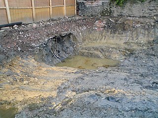
Shpack Landfill is a hazardous waste site in Norton, Massachusetts. After assessment by the United States Environmental Protection Agency (EPA) it was added to the National Priorities List in October 1986 for long-term remedial action. The site cleanup is directed by the federal Superfund program. The Superfund site covers 9.4 acres, mostly within Norton, with 3.4 acres in the adjoining city of Attleboro. The Norton site was operated as a landfill dump accepting domestic and industrial wastes, including low-level radioactive waste, between 1946 and 1965. The source of most of the radioactive waste, consisting of uranium and radium, was Metals and Controls Inc. which made enriched uranium fuel elements for the U.S. Navy under contract with the U.S. Atomic Energy Commission. Metals and Controls merged with Texas Instruments in 1959. The Shpack landfill operation was shut down by a court order in 1965.

The Koppers Co., Inc. (KCI) Superfund Site is one of three Superfund sites in Oroville, California, along with Louisiana Pacific Sawmill and Western Pacific Railyard. The KCI Superfund Site is a 200-acre site which served as a wood treatment plant for 50 years. Wood was treated with many chemicals to prevent wood deterioration. The accumulation of these chemicals from spills, fires, and uses has caused this site to be contaminated with the hazardous waste material. Due to soil and groundwater contamination, the site was placed on the National Priorities List in 1984 for remedial action plans to clean up the site to protect surrounding residential areas concerning environmental and human health risks.
The Casmalia Resources Hazardous Waste Landfill was a 252–acre disposal facility located in the hills near Casmalia, California. During its operation, 4.5 billion pounds of hazardous waste from up to 10,000 individuals, businesses and government agencies were dumped on site. The facility was closed in 1989, and is now a listed as a Superfund Site by the Environmental Protection Agency.

Moyer's Landfill was a privately owned landfill in Collegeville, Pennsylvania, United States. It was originally farmland outside the town. In the 1940s, the owner started accepting trash and municipal waste as a way to make additional money. The original landfill was 39 acres and did not have a liner to protect the land from contaminate. A liner was added to a new section in the late 1970s. Over time, the landfill accepted sewage, and industrial wastes which contained hazardous substances in addition to municipal waste. The site was closed by the EPA in 1981, and was one of the first "Superfund" sites added to the National Priorities List.
Emmell's Septic Landfill (ESL) is located at 128 Zurich Ave, Galloway Township, New Jersey and takes up about 38 acres of space. The landfill was in operation from 1967 until 1979. ESL disposed of liquid and solid waste including many chemicals such as volatile organic compounds (VOCs), Polychlorinated Biphenyls (PCBs), Trichloroethene and Vinyl chloride which all had their own effect on the environment and community. These chemicals affected the groundwater required millions of dollars to reconstruct the groundwater pathways and provide clean water to residents. The landfill holds a Hazardous Ranking Score of a 50/100, qualifying for the Superfund National Priority List. In August 1999, the state acknowledged the site's contamination and held town meetings and provided research upon the site such as groundwater samples. In July 1997, a sitewide investigation was called upon by the United States Environmental Protection Agency. In total the clean up was estimated to cost $5 million to fund this superfund site, and a grant of $3.9 million was given by the Federal Government under the Recovery Act Funding (Previti). Today, the project is still ongoing however, greatly improved since the landfill was discovered.
Bog Creek Farm, located in Howell Township, New Jersey, is a designated Environmental Protection Agency (EPA) Superfund site. Lying on 12 acres of land, Bog Creek Farm is home to several hazardous and life-threatening contamination beginning in 1973 and continuing for a year. Over a decade later, actions began to take place to clean and restore the contaminated soil and water. Bog Creek Farm is situated near several other farms that house horses, growing crops and flowers, and livestock. Less than a mile down the road lies Allaire State Park, a park used by golfers, hunters, and fisherman.
The Burnt Fly Bog Superfund Site is located in Marlboro Township in Monmouth County, New Jersey. Contamination began in the 1950s and 1960s. It was used as a dumping ground for hazardous chemicals and oils. This site was used to reprocess or recycle oil, and it was also used as a landfill during the 1950s. The contamination affected the surface water and soil. The EPA got involved in the 1980s and addressed the situation. Human health concerns were a main part of the EPA getting involved because residents lived only about 1,000 to 2,000 feet around the site. Major components of the remedy included excavation and off-site disposal of contaminated soil from Northerly Wetlands, Tar Patch Area. The back filling of the areas addressed, monitoring of the surface water and sediments, and biological sampling in the Westerly Wetlands. The current status of the site is complete. The remedial stages were completed in the late 1990s and a five-year monitoring of the surface water was completed around 2004.
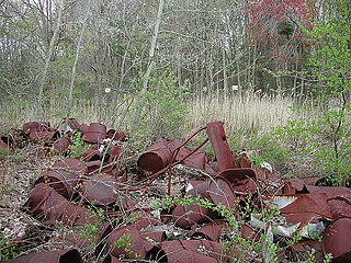
The G&H Industrial Landfill is a Superfund site located in Shelby Charter Township near Utica, Michigan. The 60-acre (24-hectare) landfill, with about 10 to 20 acres of adjacent property, operated as a waste oil recovery facility from 1955 to 1967. From 1955 to 1974 the site was used as an industrial and municipal landfill. Contaminated soil, surface water, and groundwater with hazardous chemicals have been left behind as a result of the disposal of waste solvents, waste oil and paint sludge. Operation and maintenance activities are ongoing following the cleanup.
Guam v. United States, 593 U.S. ___ (2021), was a U.S. Supreme Court case dealing with a dispute on fiscal responsibility for environmental and hazardous cleanup of the Ordot Dump created by the United States Navy on the island of Guam in the 1940s, which Guam then ran after becoming a territory in 1950 until the landfill's closure in 2011. The Supreme Court ruled unanimously that under the Comprehensive Environmental Response, Compensation, and Liability Act of 1980, Guam had filed its lawsuit to recover a portion of cleanup costs for the landfill from the United States government in a timely manner, allowing their case to proceed.

Ordot Dump, also known as Ordot Landfill, was a landfill on the western Pacific island of Guam that operated from the 1940s until 2011. Originally operated by the U.S. military, ownership was transferred to the Government of Guam in 1950, though it continued to receive all waste on the island, including from Naval Base Guam and Andersen Air Force Base, through the 1970s.
The Garfield Groundwater Contamination site is a Superfund site located in Garfield, New Jersey. The site was formally occupied by E.C Electroplating, an electroplating company that used chromic acid solution in their products. In 1983, a tank at the E.C Electroplating property malfunctioned and spilled chromic acid into the groundwater underneath the property that subsequently spread to the surrounding area. The contamination presented a health risk to Garfield residents in the area due to exposure to hexavalent chromium, a toxic form of chromium. The site was designated a Superfund site in 2011. Cleanup of the site is ongoing as of 2022.


