
Belize is a country on the north-eastern coast of Central America. It is bordered by Mexico to the north, the Caribbean Sea to the east, and Guatemala to the west and south. It also shares a maritime boundary with Honduras to the southeast. Belize is a member of the Caribbean Community (CARICOM), and is considered part of the Caribbean region and the historical British West Indies.

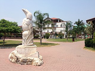
Orange Walk Town is the fourth largest town in Belize, with a population of about 13,400. It is the capital of the Orange Walk District. Orange Walk Town is located on the left bank of the New River, 53 miles (85 km) north of Belize City and 30 miles (48 km) south of Corozal Town. Despite the English name of the city, its residents are primarily Spanish-speaking mestizos.

Toledo District is the southernmost and least populated district in Belize. Punta Gorda is the District capital. According to the Human Development Index (HDI), it is the second most developed region in the country. The district has a diverse topography which features rainforests, extensive cave networks, coastal lowland plains, and offshore cays. Toledo is home to a wide range of cultures such as Mopan, Kekchi Maya, Creole, Garifuna, East Indians, Mennonites, Mestizos, and descendants of US Confederate settlers.
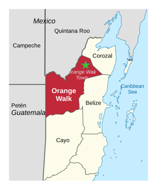
Orange Walk District is a district in the northwest of the nation of Belize, with its district capital in Orange Walk Town.
San Ignacio and Santa Elena are towns in western Belize. San Ignacio serves as the cultural-economic hub of Cayo District. It got its start from mahogany and chicle production during British colonisation. Over time it attracted people from the surrounding areas, which led to the diverse population of the town today. San Ignacio is the largest settlement in Cayo District and the second largest in the country, after Belize City.

Shipyard, also called Shipyard Colony, is a Mennonite settlement that is also an administrative village in the Orange Walk District of Belize.

Spanish Lookout is a settlement in the Cayo District of Belize in Central America. According to the 2010 census, Spanish Lookout had a population of 2,253 people in 482 households. Spanish Lookout is a community of Mennonites.
New Bothwell, originally called Kronsthal, is a local urban district in the Rural Municipality of Hanover, Manitoba, Canada. It is located approximately 15 kilometres northwest of Steinbach on Provincial Road 216, one kilometre south of Provincial Road 311 and six kilometres north of Highway 52. It has a population of approximately 500.

Mountain Pine Ridge Forest Reserve is a protected area in the Cayo District of southern central Belize. It was established in 1944 to protect and manage the native Belizean pine forests. Its boundaries are poorly defined, but it is estimated to cover an area of 106,352.5 acres (430 km2), although much of the reserve has been leased.

Tourism in Belize is a major industry in the country. The sector has grown in the 2020s, with international arrivals reportedly increasing 30% in 2024, the highest rate in the Caribbean. Former Prime Minister Dean Barrow stated his intention to use tourism to combat poverty throughout the country.
The Rio Bravo Conservation and Management Area is a nature reserve located in north-western Belize.

Mennonites in Belize form different religious bodies and come from different ethnic backgrounds. There are groups of Mennonites living in Belize who are quite traditional and conservative, while others have modernized to various degrees.

Blumenort is a local urban district in the Canadian province of Manitoba. It is located in the Rural Municipality of Hanover, 4.1 kilometres north of the city of Steinbach. It was founded in 1874 by Plautdietsch-speaking Mennonite farmers from the Russian Empire. Today, its economy is based on agriculture and the service industry.
Kleine Gemeinde is a Mennonite denomination founded in 1812 by Klaas Reimer in the Russian Empire. The current group primarily consists of Plautdietsch-speaking Russian Mennonites in Belize, Mexico and Bolivia, as well as a small presence in Canada and the United States. In 2015 it had some 5,400 baptized members. Most of its Canadian congregations diverged from the others over the latter half of the 20th century and are now called the Evangelical Mennonite Conference.
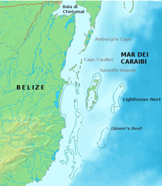
Glover's Reef is a partially submerged atoll located off the southern coast of Belize, approximately 45 km (28 mi) from the mainland. It forms part of the outermost boundary of the Belize Barrier Reef, and is one of its three atolls, besides Turneffe Atoll and Lighthouse Reef.
Upper Barton Creek is a mixed Mennonite settlement and expats in Cayo District in Belize in the area of the Barton Creek. The Mennonites in Upper Barton Creek are ethnic Mennonites of the Noah Hoover group.
Belizean Spanish is the dialect of Spanish spoken in Belize. It is similar to Caribbean Spanish, Andalusian Spanish, and Canarian Spanish. While English is the only official language of Belize, Spanish is the common language of majority (62.8%), wherein 174,000 speak some variety of Spanish as a native language. Belizeans of Guatemalan, Honduran, Mexican, Nicaraguan, Salvadoran, and even Cuban descent may speak different dialects of Spanish, but since they grow up in Belize, they adopt the local accent.

Shipstern Conservation and Management Area is a protected area located in the Corozal District of northeastern Belize.

Lighthouse Reef is an atoll in the Caribbean Sea, the easternmost part of the Belize Barrier Reef and one of its three atolls, the other two being Turneffe Atoll and Glover's Reef. Lighthouse Reef is located about 80 kilometres (50 mi) southeast of Belize City. The atoll is of oblong shape, approximately 35 kilometres (22 mi) long from north to south, and about 8 kilometres (5.0 mi) wide. It forms a shallow sandy lagoon with an area of 120 square kilometres (46 sq mi) and a depth between 2 and 6 metres deep.

