Ainring

Last updated
Ainring
Aussicht Ainring 02.JPG
Ainring
Wappen Ainring.svg
Location of Ainring within Berchtesgadener Land district
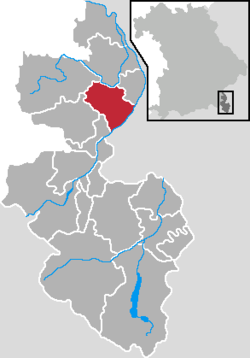
Ainring in BGL.png
Germany adm location map.svg
Red pog.svg
Ainring
Bavaria location map.svg
Red pog.svg
Ainring
Coordinates: 47°48′49″N12°56′34″E / 47.81361°N 12.94278°E / 47.81361; 12.94278 Coordinates: 47°48′49″N12°56′34″E / 47.81361°N 12.94278°E / 47.81361; 12.94278
Country Germany
State Bavaria
Admin. region Oberbayern
District Berchtesgadener Land
Government
   Mayor (202026) Martin Öttl [1]
Area
  Total32.97 km2 (12.73 sq mi)
Elevation
459 m (1,506 ft)
Population
 (2020-12-31) [2]
  Total9,847
  Density300/km2 (770/sq mi)
Time zone UTC+01:00 (CET)
  Summer (DST) UTC+02:00 (CEST)
Postal codes
83404
Dialling codes 08654 & 08656
Vehicle registration BGL
Website www.ainring.de

Ainring is a municipality in the district of Berchtesgadener Land, Upper Bavaria, Germany, near the border to Austria.

Contents

After World War II it was the site of a displaced persons camp. [3]

Church st laurentius ainring bavaria germany.jpg

Personalities

Sons and daughters Ainrings

Connected to Ainring

Related Research Articles

Oberaudorf Municipality in Bavaria, Germany

Oberaudorf is a municipality in the district of Rosenheim in Bavaria in Germany. It lies on the river Inn.

Piding Municipality in Bavaria, Germany

Piding is an approved climatic spa in Bavaria near to the border of Austria close to Bad Reichenhall and Freilassing.

Bad Wörishofen Town in Bavaria, Germany

Bad Wörishofen is a spa town in the district of Unterallgäu in Bavaria, Germany, known for the water-cure (hydrotherapy) developed by Sebastian Kneipp (1821–1897), a Catholic priest who lived there for 42 years. Many of the resort hotels and boarding-houses in Bad Wörishofen offer their guests treatment using Kneipp's methods.

Hersbruck Town in Bavaria, Germany

Hersbruck is a small town in Middle Franconia, Bavaria, Germany, belonging to the district Nürnberger Land. It is best known for the late-gothic artwork of the Hersbruck altar, the "Hirtenmuseum" and the landscape of Hersbruck Switzerland.

Waldkraiburg Town in Bavaria, Germany

Waldkraiburg is a town in the district of Mühldorf, in Bavaria, Germany with a population of about 24,000. It is the biggest town in the district of Mühldorf. It is located on the river Inn, approximately ten kilometers southwest of Mühldorf and sixty kilometers east of Munich. Waldkraiburg is one of the Bavarian displaced person cities. During World War II, an armour factory fabricated gunpowder in this area. The remaining bunkers were soon used as makeshift housing for displaced persons from Sudetenland and Bohemia.

Pocking Town in Bavaria, Germany

Pocking is a town in the district of Passau, in Lower Bavaria, Germany. It is situated about 30 km south-west of Passau, close to the Austrian border.

Röthenbach an der Pegnitz Town in Bavaria, Germany

Röthenbach an der Pegnitz is a town in the district of Nürnberger Land, in Bavaria, Germany. It is situated on the Pegnitz River, 4 km southwest of Lauf an der Pegnitz, and 12 km east of Nuremberg (centre).

Grünwald, Bavaria Municipality in Bavaria, Germany

Grünwald is a municipality in the district of Munich, in the state of Bavaria, Germany. It is located on the right bank of the Isar, 12 km southwest of Munich (centre). As of 31 December 2011 it had a population of 11,109.

Berching Town in Bavaria, Germany

Berching is a town in the district of Neumarkt in Bavaria, Germany.

Neunburg vorm Wald Town in Bavaria, Germany

Neunburg vorm Wald is a municipality in the district of Schwandorf, in Bavaria, Germany. It is situated 21 km east of Schwandorf on the river Schwarzach, a tributary of the Naab.

Scheinfeld Town in Bavaria, Germany

Scheinfeld is a town in the Neustadt (Aisch)-Bad Windsheim district, in Bavaria, Germany. It is situated 14 km northwest of Neustadt (Aisch), and 40 km east of Würzburg. Schloss Schwarzenberg is adjacent to the town. The town is home to an Adidas testing factory.

Schillingsfürst Town in Bavaria, Germany

Schillingsfürst is a municipality in the district of Ansbach, in Bavaria, Germany. It is situated 12 km southeast of Rothenburg ob der Tauber, and 23 km west of Ansbach.

Hahnbach Municipality in Bavaria, Germany

Hahnbach is a municipality in the district of Amberg-Sulzbach in Bavaria in Germany. There are living at the moment about 5000 people. The most important districts are: Fronbergsiedlung, Friedhofsiedlung, Süd 3, Markt. About 2000 of the 5000 people are not living in Hahnbach by itself, they are living in villages like Dürnsricht or Iber, which are in the area of Hahnbach. SSince 2014, the Mayor of Hahnbach is Bernhard Lindner (CSU). The CSU is the most popular party in Hahnbach, at the last election they got more than 75% of the votes, at place two was the SPD with at least 20% of the votes. The most important objects of interest are the Amberger Tor and the Fahrraddenkmal, which shows a biker holding his bike. The church in Hahnbach is called St. Jakobus Church. The sports team is called SV Hahnbach.

Bayerisch Gmain Municipality in Bavaria, Germany

Bayerisch Gmain is a municipality in the district of Berchtesgadener Land in Bavaria in Germany.

Teisendorf Municipality in Bavaria, Germany

Teisendorf is a municipality in the district of Berchtesgadener Land in Bavaria in Germany.

Lam, Bavaria Municipality in Bavaria, Germany

Lam is a municipality in the district of Cham in Bavaria in Germany. It lies within the scenic valley of the Lamer Winkel.

Seinsheim Municipality in Bavaria, Germany

Seinsheim is a municipality in the district of Kitzingen in Bavaria in Germany. It is best known for its connection with the comital Seinsheim family, which died out in 1958 with the exception of the princely House of Schwarzenberg branch of the family.

Mainleus Municipality in Bavaria, Germany

Mainleus is a municipality in the district of Kulmbach in Bavaria in Germany, the site of a post World War II American sector displaced person camp.

Eching am Ammersee Municipality in Bavaria, Germany

Eching am Ammersee is a municipality in the district of Landsberg in Bavaria in Germany. It has a size of 6.15km2.

Markt Wald Municipality in Bavaria, Germany

Markt Wald is a municipality in the district of Unterallgäu in Bavaria, Germany.

References

  1. Liste der ersten Bürgermeister/Oberbürgermeister in kreisangehörigen Gemeinden, Bayerisches Landesamt für Statistik, accessed 19 July 2021.
  2. "Tabellenblatt "Daten 2", Statistischer Bericht A1200C 202041 Einwohnerzahlen der Gemeinden, Kreise und Regierungsbezirke". Bayerisches Landesamt für Statistik (in German). June 2021.
  3. Wyman, Mark (1998). Dps: Europe's Displaced Persons, 1945-1951. Cornell paperbacks. p. 116. ISBN   9780801485428 . Retrieved December 27, 2012.